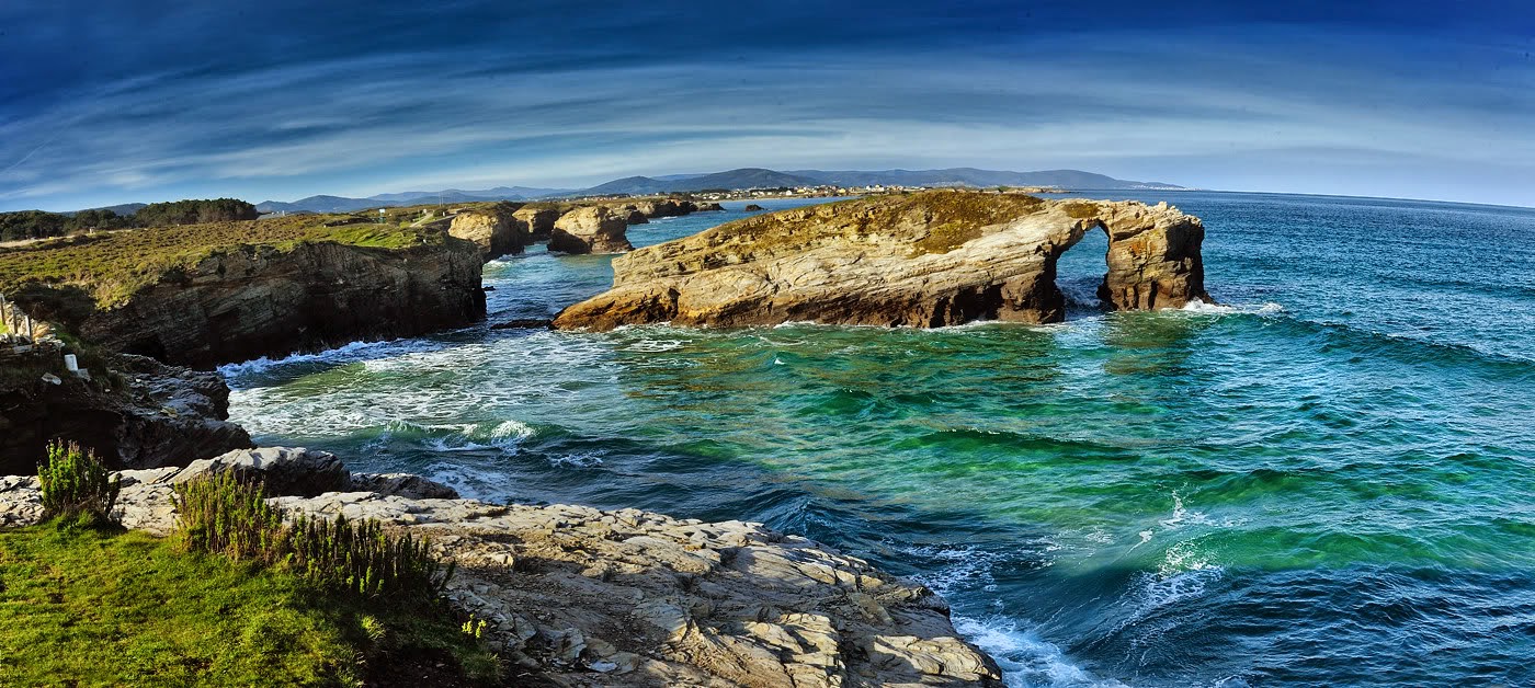
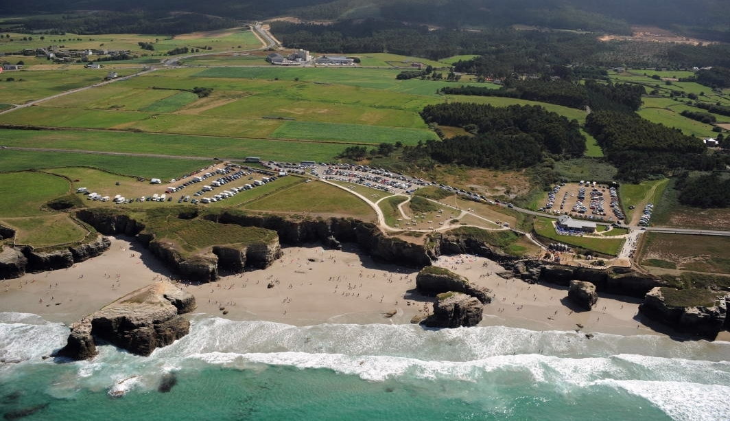
PLAYA DE LAS CATEDRALES
ESPAÑOL
La Playa de las Catedrales es el nombre turístico de la "Praia de Augas Santas", situada en el municipio de Ribadeo, en la costa de la provincia de Lugo (Galicia), sobre el mar Cantábrico, en la denominada Mariña Lucense, está declarada Monumento Natural por la Consejería de Medio Ambiente de la Xunta de Galicia.
¿POR QUÉ EL NOMBRE DE LAS CATEDRALES? Se debe a las bóvedas, arcos, galerías, cavernas que el agua y el viento han esculpido en las rocas simulando los arbotantes y contrafuertes de las maravillosas catedrales góticas, pero además los murmullos y los silbidos del viento al filtrarse entre los huecos y las chimeneas suenan como las notas de un órgano en plena actuación.
Durante la pleamar la playa es relativamente pequeña, de fina arena y que sigue siendo adecuada para el baño. Es interesante ver la playa, con la marea alta, recorriendo la parte superior de los acantilados en dirección Oeste-Este hacia la playa de Esteiro para admirar su belleza desde lo alto que dejará sorprendido a más de uno...
Con marea baja (bajamar) se podrá disfrutar de esta playa y de sus monumentos, descendiendo por las escaleras que nos dan acceso a un largo arenal de 1.328 metros de arena blanca, delimitado por una pared rocosa de pizarra y esquisto, erosionada en formas caprichosas: arcos de más de treinta metros de altura ,grutas de decenas de metros, pasillos de arena entre bloques de roca y apreciar la magnitud de los acantilados y la evolución de las distintas furnas o cuevas marinas en su formación desde pequeñas grietas hasta cuevas en las que acaba colapsando el techo por la acción erosiva del oleaje y el agua del mar.
Con las "mareas vivas" en las que las mareas bajan más y suben más que las mareas normales incluso se puede acceder a las playas vecinas por la arena, aunque eso sí se debe tener precaución y volver antes de que comience a subir la marea ya que el nivel del mar sube rápidamente puesto que se trata de un tramo de costa prácticamente horizontal perteneciente a la Rasa Cantábrica.
Al final de la playa es donde encontraremos el paisaje más espectacular, la típica imagen de los arcos en fila, unos detrás de otros.
Antes de visitar la playa, sería bueno consultar las mareas, os dejamos un enlace donde podeis hacerlo
Tabla de Mareas
ZONA LITORAL
La zona litoral o costera es la parte de la plataforma continental más cercana a tierra firme. Representa la interfase de los 3 grandes medios del planeta (Atmósfera, Hidrósfera y Litósfera) por lo que presenta características muy peculiares, como por ejemplo, los cambios del nivel del mar o mareas y la erosión, que depende entre otros factores de la dirección del viento, de los materiales geológicos que forman la costa, de la intensidad de las mareas y corrientes, de la orientación de la propia costa, etc. Todos estos factores hace que cada zona costera presente características muy particulares.. De las razones que inciden en el considerable dinamismo del litoral destacan los procesos geomorfológicos dominantes, que diferencian dos tipos de costa, de erosión (acantilados) y de sedimentación (playas, arenales y humedales costeros).
TIPOS DE COSTA
Aunque no hay dos trozos de costa exactamente iguales, se pueden hacer generalizaciones que nos permitan utilizar características fácilmente apreciables para definir modelos elementales del perfil litoral como:
*Según el tipo de erosión.
*Según los movimientos epirogénicos.
*Según el sustrato dominante.
*SEGÚN EL GRADO DE EXPOSICIÓN AL VIENTO Y A LAS OLAS:
El agente que actúa es el agua marina y la energía de las olas del mar procede de las mareas y del viento.
Los procesos que se llevan a cabo son: erosión, transporte y sedimentación.
El tamaño y la fuerza de las olas que golpean contra la línea costera tienen su efecto en el grado de erosión. Bajo condiciones normales, las olas pueden erosionar la línea de la costa a un promedio de 1 a 1.5 metros por año. Durante las tormentas la acción de las olas puede aumentar. Olas enormes golpean con mayor fuerza. El nivel de erosión de la línea costera puede aumentar a 25 metros en un día.
Según el tipo de roca que compone la línea costera le afecta el grado de erosión. Algunas rocas no se erosionan tan rápido como otras.
La fuerza de las olas adquiere intensidades según la potencia del viento, la profundidad y características del fondo. Esta fuerza puede ser de 30 toneladas por metro cuadrado. Se ha calculado que a 70 metros de profundidad las olas ejercen todavía una acción .
Los cambios en el perfil de las costas ocurren como consecuencia del golpe directo de las olas, que ejercen una fuerza muy grande, especialmente durante los fuertes temporales. A esta fuerza se suma la presión generada por el aire comprimido que va por delante de la ola.
Los fragmentos que las olas van arrancando a las rocas o los que ya existían en el fondo del mar, son lanzados por las olas una y otra vez, contribuyendo enérgicamente al modelado de la costa.
Entre las corrientes que intervienen en la configuración de la costa destacan, a saber, las originadas por el ir y venir de las olas, que genera las corrientes de incidencia y de resaca, las cuales desgastan las rocas y transportan los materiales resultantes de este desgaste; en otro caso sobresalen las de marea, que pueden alcanzar fuerza cuando se desplazan por lugares estrechos, adquiriendo mayor velocidad.
El viento es uno de los factores que ha hecho cambiar más la fisonomía de las costas. Así, al soplar desde mar adentro hacia tierra, y a la inversa, provoca alteraciones en el nivel del agua.
El principal proceso químico que se observa en las costas es el de disolución, o sea, el agua del mar es capaz en este caso de disolver las rocas, provocándoles oquedades o aislando fragmentos y confiriéndoles estructuras peculiares.
Los agentes internos corresponden a las características propias de la estructura de las rocas de la costa, como la naturaleza y grado de dureza de las mismas, la abundancia y tamaño de los materiales sueltos, la profundidad del mar en las proximidades de la orilla.
La erosión de las costas rocosas provocada por las olas sucede lentamente, aun en los lugares donde las rocas son relativamente blandas. Los índices de erosión por año en los acantilados son de un metro, y representa aproximadamente el 5 por ciento del material de erosión que llega a las playas del mundo.
Como resultado de la erosión y de la acumulación, los litorales van adquiriendo una topografía muy peculiar.
ELEMENTOS DEL LITORAL
Destacan las siguientes formas de erosión por la acción del mar:
ACANTILADOS, PLATAFORMA DE ABRASIÓN, LOS ARCOS NATURALES, ISLOTES, FARALLONES Y CUEVAS:
Es muy importante el tipo de roca que exista, pues en función de su naturaleza y del tipo de pendiente al mar, actuará de diferente manera la erosión ambiental con lo que se verá condicionado el hábitat y, por lo tanto, la vida que allí se desarrolle. La roca formada por materiales más o menos blandos, suelen cobijar un número más abundante de seres vivos que la roca dura tipo granito.
Viento, exposición al sol, salinidad, son factores que influyen en gran medida en las zonaciones de estos acantilados.
La erosión de las olas forma accidentes geográficos en la línea costera.
Esta erosión puede producir paredones verticales rocosos llamados acantilados marinos, donde la erosión es más intensa en su base debido a que la fuerza del oleaje y el impacto de los fragmentos rocosos son mayores. Así, la roca queda desnuda, vulnerable a la formación de entrantes, cuevas o galerías que, cuando alcanzan determinado tamaño causan el hundimiento o desplome —según los distintos tipos de roca de la parte superior. De esta manera el acantilado retrocede ante la socavación de su base.
La forma, altura y demás caracteres del acantilado varían de acuerdo en el tipo de roca. En las rocas compactas, como las calizas, cuarcitas y basaltos, el acantilado se forma alto y vertical, mientras que en las más blandas, como las mangas y arcillas, la pendiente se hace más tenue por los deslizamientos. En ello también influye la disposición de las rocas. Cuando los estratos son horizontales, verticales o de inclinación opuesta al mar, se favorece la formación de cantiles abruptos; por el contrario, cuando las capas están inclinadas hacia el mar, producen pendientes más suaves, en favor de los planos de estratificación.
En las costas con material compacto, la formación de los acantilados es más o menos uniforme, dando una costa casi recta donde los tramos más resistentes constituyen las salientes o promontorios.
Si los promontorios siguen siendo golpeados por el oleaje suelen formarse cuevas en ambos lados. Dichas cuevas pueden ser tan profundas que llegan a comunicarse entre sí produciendo arcos o puentes naturales Estos arcos pueden derrumbarse y dar origen a un islote costero separado de la línea de la costa llamados farallones.
La acción desgastadora del mar sobre el acantilado produce pequeñas grietas que, al aumentar de tamaño, se convierten en cuevas marinas. Cuando el agua entra a presión por la cueva, el aire de ésta se comprime y tiende a salir violentamente por la parte superior, acompañado de agua pulverizada, produciendo una especie de rugido. A este tipo de formación costera se le ha llamado hoyo soplador o bufones.
El perfil y evolución de los acantilados va a depender de la disposición que presentan los materiales frente a la línea de costa y a las características de los mismos (las arenas compactadas también dan origen a acantilados).
Por su posición respecto a la línea de costa y por cómo se ven afectados por la dinámica marina litoral, se distinguen, de manera general, dos tipos de acantilados:
*Acantilados activos: Son acantilados sobre aguas profundas, su base está batida por el oleaje y los materiales erosionados no se depositan en su base, sino que son trasladados por las corrientes marinas.
*Acantilados inactivos: Son acantilados sobre plataformas arenosas, se sitúan fuera del alcance del oleaje y están retirados respecto a la línea de costa.
Los acantilados son en sí mismos ambientes poco acogedores para la vegetación, que sólo puede desarrollarse en pequeñas grietas y rellanos. Además, la vegetación de acantilado muestra un grado alto de especialización, al estar sometida a condiciones ambientales rigurosas: exposición al viento, salinidad, escaso desarrollo edáfico y escasa disponibilidad hídrica.
La vegetación ofrece una distribución zonal. En la zona de impacto del oleaje tan sólo viven algunos líquenes especializados, por encima se desarrolla una vegetación halófita que va variando su disposición según su grado de tolerancia a la salinidad. Su importancia e interés para la conservación radica en la presencia de numerosos endemismos, muchos de ellos a nivel local.
En cuanto a la fauna, los acantilados son colonizados por numerosas aves marinas, ya que ofrecen lugares de nidificación y posadero.
Los acantilados, como medio terrestre abrupto que se introduce en el mar, junto con su papel como mirador u observatorio, son uno de los puntos de mayor atracción visual y paisajística del litoral.
CACHÉ
Para logear este caché como encontrado deberás enviarnos un e-mail con las respuestas correctas:
1) ¿Qué procesos se llevan a cabo para que la costa de Ribadeo sea un acantilado? ¿Cuáles son los agentes que lo producen?
2) ¿Qué tipo de rocas dan lugar a que un acantilado sea alto y vertical?.
3) En dirección Este coge el sendero y párate delante del farallón con arco, a tus píes hay un mojón en el sendero, anota las iniciales que aparecen en él.
4) Opcional: Publicar una foto vuestra en esta marávillosa playa.
ENGLISH
The Beach of the Cathedrals is the tourist name of "Holy Augas ", located in the municipality of Ribadeo, on the coast of the province of Lugo (Galicia), on the Bay of Biscay, in the so-called Lugo Coast, is declared Natural Monument by the Ministry of Environment of the Government of Galicia.
WHY THE NAME OF THE CATHEDRALS? Is due to the vaults, arches, galleries, caves that water and wind have carved the rocks simulating the flying buttresses and buttresses of Gothic cathedrals wonderful, but also murmurs and wind whistles to seep between the gaps and fireplaces sound like the notes of an organ in full action.
During high tide the beach is relatively small, with fine sand and that is still suitable for swimming. It is interesting to see the beach at high tide, covering the top of the cliffs in west-east direction towards Esteiro beach to admire its beauty from above that will surprise more than one...
Low tide (low tide) you can enjoy this beach and its monuments, descending the stairs that give us access to a long beach of white sand 1328 meters, bounded by a wall of slate and shale rock, eroded into strange shapes : arches over thirty meters high, ten meters caves, sandy corridors between blocks of rock and appreciate the magnitude of the cliffs and the evolution of different furnas or sea caves in its formation from small cracks to caves in the collapsing the roof just by the erosive action of the waves and the sea water.
</ p> With the "tides" in which the tides rise and fall more than normal tides can even access to nearby beaches with sand, but yes you should be cautious and get back before the tide begins to rise and that the sea level rises quickly since it is a substantially horizontal stretch of coastline belonging to the Cantabrian Rasa.
At the end of the beach is where we will find the most spectacular scenery, the typical image of the arcs in a row, one behind the other..
Before visiting the beach, it would be good to check the tides, you leave a link where you can do it
Tide table
COAST LINE
Littoral or coastline area is the part of the continental shelf closer to shore. Represents the interface of the Big 3 means the planet (Atmosphere, Hydrosphere and Lithosphere) and thus has very peculiar characteristics, such as changes in sea level and tides and erosion, which depends among other factors on the direction of wind, geologic materials that make up the coast, the intensity of tides and currents, the orientation of the coast itself, etc.. All these factors makes each coastal zone present very specific characteristics .. Of the reasons that affect the coastal strong performance highlights dominant geomorphological processes that differentiate two types of coast erosion (cliffs) and sedimentation (beaches, beaches and coastal wetlands).
TYPES OF COASTLINE
Although no two pieces are exactly alike coast, generalizations can be made that allow us to use features readily apparent to define elementary coastal profile models such as:
*Depending on the type of erosion.
* According epirogénicos movements.
* According to the dominant substrate.
* BY DEGREE OF EXPOSURE TO WIND AND WAVES:
The agent acting is seawater and the energy of ocean waves comes from the tides and wind.
The processes carried out are: erosion, transport and deposition.
The size and strength of the waves crashing against the shoreline have their effect on the degree of erosion. Under normal conditions, waves can erode the coastline at an average of 1 to 1.5 meters per year. During storms the wave action may increase. Huge waves strike hardest. The level of erosion of the coastline can be increased to 25 meters in a day.
Depending on the type of rock that makes up the coastline will affect the degree of erosion. Some rocks do not erode as fast as others.
The force of the waves becomes intensities as wind power, depth and bottom features. This force can be 30 tons per square meter. It has been estimated that 70 meters deep waves still exert an action.
The changes in the profile of the costs occur as a result of direct hit from the waves, which have a very large force, especially during heavy storms. To this is added the pressure force generated by the compressed air that is ahead of the wave.
Fragments waves are starting to rocks or already exist in the deep sea, are thrown by the waves over and over again, contributing strongly to the modeling of the coast.
Streams that are involved in the configuration of the coast include, namely, those caused by the ebb and flow of waves, currents generated by incidence and hangover, which wear down the rocks and transport the materials related to this wear , otherwise excel tide, which can reach force when moving through narrow places, gathering momentum.
Wind is one of the factors that has changed over the face of the coast. So, blowing from sea to land, and conversely, causes changes in the water level.
The primary chemical process is observed in the costs is the dissolution, namely the sea water in this case is capable of dissolving the rock, causing voids or isolating fragments and conferring unique structures.
Internal agents correspond to the characteristics of the structure of the rocks of the coast, as the nature and degree of hardness of them, the abundance and size of loose materials, the depth of the sea in the vicinity of the shore.
The rocky shoreline erosion caused by waves happens slowly, even in places where the rocks are relatively soft. Rates of erosion per year in the cliffs are a meter, and represents approximately 5 percent of erosion material that reaches the beaches of the world.
As a result of erosion and accumulation, coastlines are acquiring peculiar topography.
ELEMENTS OF THE COAST
These include the following forms of erosion by wave action:
CLIFFS, ABRASION PLATFORM, NATURAL ARCHES, ISLANDS,FARALLONES AND CAVES:
It is very important rock type exists, then depending on their nature and the type of slope to the sea, act differently environmental erosion thus be conditioned habitat and, therefore, that there is life develop. The rock formed by more or less soft materials, often harboring most abundant numbers of living beings that granite-hard rock.
Wind, sun exposure, salinity, are factors that greatly influence the zonation of these cliffs.
Wave erosion landforms form at the coastline.
This erosion can produce vertical walls rocky sea cliffs called, where erosion is most intense at the base because the force of the waves and the impact of rock fragments are greater. Thus, the rock is naked, vulnerable to the formation of starters, caves or galleries when they reach a certain size cause subsidence or collapse, according to the different types of rock on top. Thus the cliff back to the undermining of the base.
Shape, height and other characters of the cliff vary in the type of rock. In compact rocks, such as limestone, quartzite and basalt, the cliff top and vertical form, while the softer clays like sleeves and, the slope becomes more tenuous by landslides. It also affects the arrangement of the rocks. When the layers are horizontal, vertical or sea opposite inclination, favors the formation of steep cliffs on the contrary, when the layers are inclined towards the ocean, produce more gentle slopes, towards bedding planes.
On the coasts with compact material, the formation of the cliffs is more or less uniform, giving an almost straight coastline where are the toughest sections projections or headlands.
If the headlands are still beaten by waves caves usually form on both sides. These caves can be so deep that come to communicate with each other producing bows. These arches or natural bridges may collapse and give rise to a island separated from the coastal shoreline cliffs called .
Desgastadora action of the sea on the cliff produces small cracks, the increase in size, become sea caves. When pressurized water enters the cave, the air is compressed and tends it out violently at the top, accompanied by water spray, producing a roar. This type of training has been called coastal blowhole or jesters.
The profile and evolution of the cliffs will depend on the provision that the materials presented in front of the waterfront and the characteristics thereof (compacted sands also give rise to cliffs).
By its position on the waterfront and how they are affected by coastal marine dynamics are distinguished, in general, two types of cliffs
* Cliffs assets: cliffs are deep, its base is whipped by waves and eroded materials are not deposited at the base, but are transported by ocean currents.
* Cliffs inactive: platforms are sandy cliffs, fall outside the scope of the waves and are removed from the line of coast.
The cliffs themselves are unwelcoming environments for vegetation, which can only develop in small cracks and landings. Furthermore, cliff vegetation shows a high degree of specialization, to be subjected to harsh environmental conditions: wind exposure, salinity, poor development and poor edaphic water availability.
The vegetation offers a zonal distribution. In the wave impact zone live only some specialized lichens, above develops halophyte vegetation available that varies according to the degree of tolerance to salinity. Its importance and conservation concern is the presence of numerous endemic species, many of them locally.
In terms of fauna, the cliffs are colonized by numerous seabirds, as they provide nesting sites and innkeeper.
cliffs as abrupt terrestrial environment is introduced into the sea, along with its role as a lookout or observatory, are one of the most attractive visual and scenic coastline.
CACHÉ
For this cache as found logear must send an e-mail with the correct answers:
1) What processes are carried out for the coast Ribadeo is a cliff? What are the agents that produce?
2) What type of rocks leading to a cliff is high and vertical?.
3) take the path heading east and stand in front of the bluff bow at your feet is a milestone in the path, note the initials that appear in it.
4) Optional: Post one photo of you in this wonderful beach