Powell Point on Table Cliff Plateau offers unique Wasatch Limestone Formation soils that provide habitat for rare plant species that are locally endemic to southern Utah. The ancient bristlecone pines at Powell Point have weathered millenia in this unique cushion plant community surrounded by steep cliffs, open escarpments and spectacular views.
The walk from the parking area on Table Cliff Plateau out to Powell Point is approximately 1 mile and goes through high elevation stands of Engelmann Spruce and Subalpine Fir.
keep in mind that there is only one established trail in this viewing site. The soils (white Wasatch Limestone) in the area are highly erosive and littered with talus. Steep and unstable escarpments are home to several of the unique plants in the area. Adequate footwear for this kind of terrain is recommended. These loose unstable talus slopes and cliffs are very dangerous and great care should be taken when walking on the unstable slopes and escarpments. The drop from the point to the bottom is about 1000 feet down.
Lightning
When visiting in the summer, be mindful that the Table Cliff Plateau attracts massive thunderstorms that display their fury with spectacular lightning shows.
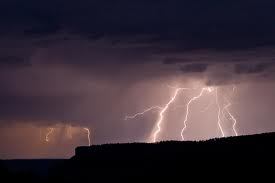
When these storms appear, it is recommended that you seek shelter immediately. Also, please be mindful that the elevation at Powell Point is 10,188 feet, so altitude and extreme weather is always a factor at any time of year. Powell Point is practically a lightening rod and is struck frequently and often. As you walk up the trail look at the trees and note how many have taken lightning strikes. The morning before hiking out to Powell Point, I was in the valley when storm clouds rolled in and I watched the plateau get struck multiple times over the course of an hour in various locations. I read a great blog about some mountain bikers that had an experience with lightning at Powell Point. Click here to read: Riding with Thor
Grand Escalante Staircase
At the point there is a panoramic view of the Grand Escalante Staircase. You can see multiple plateaus of the staircase. Canyons are a little harder to see, but they are visible. 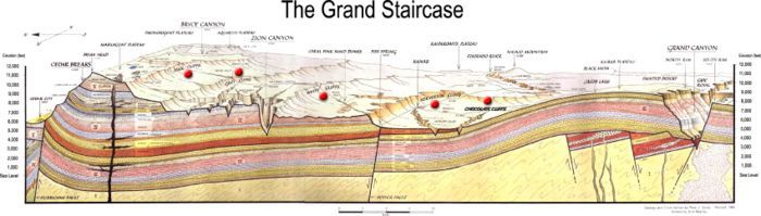
Some examples of identifiable features are:
Navajo Peak
Bryce Canyon
Markagaunt Plateau
50 Mile Bench
High Geologic Features of Lake Powell
Paunsaugunt Plateau
The Monument stretches from the towns of Big Water, Glendale and Kanab, Utah on the southwest, to the towns of Escalante and Boulder on the northeast. Encompassing 1.9 million acres, the monument is slightly larger in area than the state of Delaware. The western part of the Monument is dominated by the Paunsaugunt Plateau and the Paria River, and is adjacent to Bryce Canyon National Park. This section shows the geologic progression of the Grand Staircase. The center section is dominated by a single long ridge, called Kaiparowits Plateau from the west, and called Fifty-Mile Mountain when viewed from the east. Fifty-Mile Mountain stretches southeast from the town of Escalante to the Colorado River in Glen Canyon. The eastern face of the mountain is a steep, 2200 foot (650 m) escarpment. The western side (the Kaiparowits Plateau) is a shallow slope descending to the south and west. East of Fifty-Mile Mountain are the Canyons of the Escalante. The Monument is bound by Glen Canyon National Recreation Area on the east and south. The popular hiking, backpacking and canyoneering areas include the Canyons of the Escalante, shared with Glen Canyon National Recreation Area and Skutumpah and Cottonwood Roads. Highlights include the slot canyons of Peekaboo, Spooky and Brimstone Canyons, Bull Valley Gorge, Willis Creek, Lick Wash and the backpacking areas of lower Coyote Gulch and of Harris Wash. The Hole-in-the-Rock Road extends southeast from the town of Escalante, along the base of Fifty-Mile Mountain. It is important in the history of The Church of Jesus Christ of Latter-day Saints and the settlements of southeast Utah, including Bluff, as well as providing access to the Canyons of the Escalante, and to the flat desert at the base of Fifty Mile Mountain that is used for grazing cattle.
Logging Requirements:
1. According to the information sign, what are the two former names of Powell Point and how does that differ from the rocks at your feet?
2. In your opinion, from the patterns of erosion you see, what type of formation will this become in the future? Why did you come to this conclusion?
3. Examine the layer of limestone (thickness, color) in the top layer where you are standing then look in the distance. Do you see another formation in the distance with the same limestone type?
4. Take a photo of yourself at Powell Point. If you do not post a photo, your log will NOT be deleted, however I will secretly believe that you were never there and armchair logged this cache. After all, who comes out to this beautiful place and doesn't bring a camera? If you do post a photo, I will be very lenient on your answers...if you don't post a photo, be prepared to answer a follow up question via email.