This cache is located along the Redbird Creek Trail. The trail is a 3.1 mile loop trail that begins near the parking lot for the day use area of the park. The trail is flat but there are some roots to negotiate typical of a wooded trail. It is clearly marked and easy to follow. The cache is located within 50 feet of the trail and there is no need to bush whack. There is no need to go off trail until you are no more than 50 feet from the cache. Please be respectful of the animal and plant life and be sure to Leave No Trace behind except for your footsteps and take nothing but memories. So grab a park map and just follow your GPS receiver!
A Salt Marsh is an area of low, flat, poorly drained ground that is subject to daily or occasional flooding by salt water or brackish water and is covered with a thick mat of grasses. Salt marshes are common along low seacoasts, inside barrier bars and beaches, in estuaries, and on deltas and are also extensive in deserts and other arid regions that are subject to occasional overflow by water containing a high content of salts. Maritime salt marshes often extend many miles inland and are variably subject to tidal action.
Salt marshes are coastal wetlands that are flooded and drained by salt water brought in by the tides. They are marshy because the soil may be composed of deep mud and peat. Peat is made of decomposing plant matter that is often several feet thick. Peat is waterlogged, root-filled, and very spongy. Because salt marshes are frequently submerged by the tides and contain a lot of decomposing plant material, oxygen levels in the peat can be extremely low—a condition called hypoxia. Hypoxia is caused by the growth of bacteria which produce the sulfurous rotten-egg smell that is often associated with marshes and mud flats.
The Georgia salt marshes exist in a band approximately four to eight miles wide between the main coastline and the barrier islands. Acreage estimates are inexact, but some put the area at over 400,000 square miles.
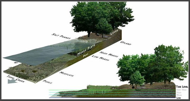
Originating from Pleistocene glacial melting, the marshes are categorized into zones, which rise gradually in elevation from the ocean toward the main coastline. The creek bank is the lowest elevation of the zones. From this low point, the land rises gradually through low marsh, high marsh, salt pan, marsh hammock, and marsh border community. The lowest elevations are flooded twice daily by incoming tides, giving the marshes a high salt content. Salt marshes occur along coastal estuaries where land meets sea and fresh water meets salt water. Marshes are semi-enclosed areas that have an opening to the sea. They are fed by incoming tides or by drainage from rivers and streams flowing into the sea, depositing sediments rich in nutrients and capable of supporting an abundance of plant and animal life.
Georgia salt marshes act as buffers against offshore storms. Without their dissipating effect, hurricanes and northeasters on the Atlantic coast would do much more damage. The destructive fury of large storm waves and tides is greatly reduced by their passage across the marsh. The grass absorbs most of the wave and current energy, which lessens the damage that can be done. Salt marshes also protect shorelines from erosion by buffering wave action and trapping sediments. They reduce flooding by slowing and absorbing rainwater and protect water quality by filtering runoff, and by metabolizing excess nutrients.
Tidal flats gain elevation relative to sea level by sediment accretion, and subsequently the rate and duration of tidal flooding decreases so that vegetation can colonize on the exposed surface. The arrival of propagules of pioneer species such as seeds or rhizome portions is combined with the development of suitable conditions for their germination and establishment in the process of colonization. When rivers and streams arrive at the low gradient of the tidal flats, the discharge rate reduces and suspended sediment settles onto the tidal flat surface, helped by the backwater effect of the rising tide. Mats of filamentous blue-green algae can fix silt and clay sized sediment particles to their sticky sheaths on contact which can also increase the erosion resistance of the sediments. This assists the process of sediment accretion to allow colonizing species to grow. These species retain sediment washed in from the rising tide around their stems and leaves and form low muddy mounds which eventually coalesce to form depositional terraces, whose upward growth is aided by a sub-surface root network which binds the sediment. Once vegetation is established on depositional terraces further sediment trapping and accretion can allow rapid upward growth of the marsh surface such that there is an associated rapid decrease in the depth and duration of tidal flooding. As a result, competitive species that prefer higher elevations relative to sea level can inhabit the area and often a succession of plant communities develops.
Salt marshes are located among different landforms based on their physical and geomorphologic settings. Such marsh landforms include deltaic marshes, estuarine, back-barrier, open coast, embayment’s and drowned-valley marshes. Deltaic marshes are associated with large rivers. Estuary marshes occur at the head of estuaries in areas where there is little wave action and high sedimentation. Back-barrier marshes are sensitive to the reshaping of barriers in the landward side of which they have been formed. They are common along much of the eastern coast of the United States.
In order to log this Earth Cache please answer the questions below. The answers can be found in the text above and at ground zero.
1. How do salt marshes protect shorelines?
2. How do tidal flats gain elevation relative to sea level?
3. Based on your observation at the posted coordinates do you believe the marsh is fed by incoming tides or by drainage from Redbird Creek? What evidence do you see to support your theory?
4. Based on your observation what type of marsh is located at the posted coordinates? Deltaic, Estuary or Back Barrier?
The next two questions can be answered from the signage at the posted coordinates:
5. “_______ affect the water levels of the salt marsh and also act to ______ _______ the system.”
6. “This important plant provides cover for animals, holds together the _____ _____ _____ _____ ” (four words)
BONUS: Any posted pictures would be greatly appreciated and will earn you extra credit!
Remember to Get Out, Get Dirty, Get Fit and enjoy the park!
Hours and fee information:
Park Hours: 7AM-10PM
Office and Museum Hours: 8AM-5PM
$5 parking. Annual passes available.
Permission for placement of this cache was granted by the Park Manager.
Remember, it is all about the miles and the smiles!