Introdução / Introduction
As rochas que compõe o Pão de Açúcar e os morros vizinhos formaram-se a cerca de 560 milhões de anos a partir de transformações (metamorfose) das rochas locais a 25 quilômetros no interior da crosta terrestre. Devido a movimentos da crosta terrestre, grandes bolsões de magna provenientes de camadas inferiores do manto terrestre, se infiltraram por entre camadas de rochas sedimentares já existentes e durante milhões de anos esfriaram transformando-se em granito. Este novo conjunto local de rochas – os novos granitos e as já existentes rochas sedimentares – foram então lentamente transformadas (metamorfoseadas), sob pressões de pelo menos 7.000 vezes a pressão atmosférica e a temperaturas acima de 600 graus centígrados, em um novo conjunto de rochas metamórficas conhecidas como gnaisses.
Gnaisse é um tipo comum e amplamente distribuído de rocha, formada por processos metamórficos regionais de alto grau a partir de formações pre-existentes que foram originalmente rochas ígneas ou sedimentares. É uma rocha metamórfica caracterizada por faixas (foliação) causadas pela separação de diferentes tipos de minerais, tipicamente silicatos claros e escuros. Ao invés de significar sua composição mineral, o termos gnaisse é mais uma indicação de textura. A “textura gnaisse” se refere a separação de minerais claros e escuros em faixas.
Veja no link abaixo uma animação mostrando a transformação de uma rocha Ígnea em metamórfica (diorito em gnaisse) e a criação das faixas características ou “textura gnaisse”
The Sugarloaf and the surrounding hills in Rio de Janeiro were formed around 560 million years ago by transformations (metamorphosis) of the local rocks 25 kilometers inside the earth’s crust. Due to Earth’s crust movements, huge magma pockets coming up from the mantle infiltrated between layers of already existing sedimentary rock and slowly cooled down to form granite. This new set of local rocks – the new granites and the previously existing sedimentary rocks – were slowly changed (metamorphosed), under pressure of at least 7,000 times the atmospheric pressure and temperatures above 600 degrees centigrade, into a new set of metamorphic rocks known as gneisses.
Gneiss is a common and widely distributed type of rock formed by high-grade regional metamorphic processes from pre-existing formations that were originally either igneous or sedimentary rocks. It is a metamorphic rock characterized by banding (foliation) caused by segregation of different types of rock, typically light and dark silicates. Rather than an indication of specific mineral composition, the term gneiss is an indication of texture. The "gneissic texture" refers to the segregation of light and dark minerals.
Check on the link below an animation showing the transformation of an igneous rock into metamorphic (diorite into gneiss) and the creation of the characteristic banding or “gneiss texture”.
http://www.classzone.com/books/earth_science/terc/content/visualizations/es0607/es0607page01.cfm?chapter_no=visualization
Pão de Açúcar Gnaisse / Sugarloaf Gneiss
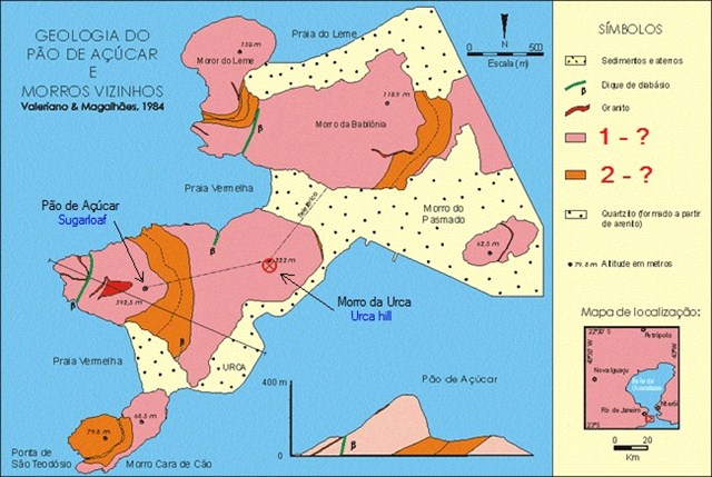
Na área da cidade do Rio de Janeiro encontram-se quatro tipos principais de gnaisses. São chamados pelos geólogos de gnaisse kinzigítico, gnaisse facoidal, gnaisse leptinítico e gnaisse archer. No complexo do morro da Urca e Pão de Açúcar encontramos 2 dos 4 tipos de gnaisse.
Gnaisse facoidal (Augen gnaisse): O Gnaisse Facoidal recebe este nome devido aos grandes cristais elípticos de feldspato, com a aparência de olhos. É uma rocha metamórfica, cuja composição química e mineralógica é notavelmente homogênea originada pelo metamorfismo de rochas ígneas graníticas. Sua composição mineralógica aproximada é : feldspato potássico ±75%, quartzo ± 20%, mica biotita ±5%. Contém ainda pequenos teores de magnetita. Gnaisse facoidal ou gnaisse augen, é um gnaisse de granulometria grosseira, com feldspatos elípticos de tamanho centimétrico orientados na mesma direção. Os outros minerais constituintes da rocha, no geral quartzo, biotita e magnetita, se agrupam em faixas que contornam os feldspatos. O termo facoidal vem do grego, phakoeidés = lenticular, em referência ao formato elíptico ou lenticular dos feldspatos. Da mesma forma o termo augen vem do alemão e significa "olhos", em referência ao formato elíptico dos feldspatos. Este tipo de gnaisse é o que compõem os morros da Urca e to Pão de Açúcar.

Four main kinds of gneisses can be found in the Rio de Janeiro city area. They are called by the geologist kinzigitic gneiss, augen (facoidal) gneiss, leptinitic gneiss and archer gneiss. In the Urca and Sugarloaf hill complex we can find 2 of these 4 gneisses.
Augen Gneiss (Facoidal gneiss): The Augen gneiss receives this name due to the big elliptical feldspar crystals, resembling eyes. It is a metamorphic rock which chemical and mineralogical composition is notably homogeneous originated by metamorphism of igneous granitic rocks. Its approximate mineralogical composition is: potassium feldspar ±75%, quartz ± 20%, mica biotite ±5%. It also contains small parts of magnetite. The Augen gneiss is a gneiss composed of coarse grains with elliptical feldspar groups on the centimeter size oriented in the same direction. The other rock minerals, in general quartz, biotite and magnetite are grouped in bands around the feldspar. The term augen comes from German meaning “eyes”, referring to the feldspar elliptic format. The same way the term facoidal gneiss, comes from the Greek phakoeidés = in the shape of lenses, also referring to the feldspar elliptic format. The Urca and Sugarloaf hills are made of this kind of gneiss.
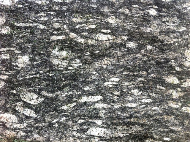
Gnaisse facoidal (Augen gneiss)
Gnaisse kinzigito: É uma rocha de cor escura interpretada como gnaisse que se origina do metamorfismo de antigas sequências sedimentares (gnaisse metasedimentar) com elevado teor de argila, o que levaria à formação de granada, biotita, cordierita e sillimanita. É um gnaisse de grau metamórfico elevado. Os minerais presentes são: granada, biotita, podendo ocorrer teores variáveis de k-feldspato, quartzo, muscovita, cordierita e sillimanita. Este tipo de gnaisse é encontrado nos terrenos que ligam o morro da Urca ao Pão de Açúcar.
Kinzigito gneiss: It is a dark rock interpreted as gneiss originated by metamorphosis of old sedimentary sequences (metasedimentar gneiss) with an elevated clay content which would lead to the formation of garnet, biotite, cordierite and sillimanite. It is a gneiss of elevated metamorphic grade. Its main minerals are garnet and biotite with variable levels of k-feldspar, quartz, muscovite, cordierite and sillimanite. This gneiss kind is found in the terrains that connect the Urca hill to the Sugarloaf.

Gnaisse kinzigito (Kingizito gneiss) – Credits: caminhosgeologicos.rj.gov.br
Fontes / Sources:
caminhosgeologicos.rj.gov.br
CPRM – Serviço Geológico do Brasil
Localização / Location:
P1: Entrada ao bondinho / Tramway entrance: S22° 57.306'S, W43° 10.017'
GZ: Topo do Morro da Urca / Urca Hill top: S22° 57.057 W43° 09.808
P2: Trilha do Morro da Urca - topo / Urca Hill trailhend - top: S22° 57.111', W43° 09.865'
P3: Rocha exposta / Rock outcrop: S22° 57.068', W43° 09.790'
P4: Trilha do Morro da Urca - base / Urca Hill trailhead - base: S22° 57.156', W43° 09.654'
Este Earthcache está localizado em local público no alto do morro da Urca. O Acesso ao topo do morro pode ser feito através do bondinho (pago) que sai da estação da Praia Vermelha (P1) diariamente de 8 às 19:30, ou através da trilha (de graça) que leva ao topo to morro da Urca. Esta trilha fica aberta entre 7 e 18 horas e o acesso se dá através da Pista Cláudio Coutinho (P4). Esta trilha tem uma duração média (ida) de 40 minutos com uma subida acentuada, muitas vezes com degraus úmidos.
This Earthcache is located in a public area atop the Urca hill. The access to the top of the hill can be made through the tramway (paid) that leaves the Praia Vermelha station (P1) daily from 8am to 7:30pm, or walking the trail (free) that takes to the top of the Urca Hill. This trail is open from 7am to 6pm and can be accessed through the Pista Cláudio Coutinho pathway (P4). This trail has an average duration (one way) of 40 minutes with a reasonable climbing ascent degree, many times with humid stair steps.
Perguntas:
Para logar esse EarthCache, envie as respostas às perguntas abaixo através de email usando o meu perfil no geocaching.com. Coloque o texto "GC4KZEY – Pão de Açúcar" na primeira linha do email. Os cachers que não enviarem as respostas em no máximo 2 semanas terão suas entradas removidas.
1 – Mande um email (não publique). Identifique o tipo de rochas metamórficas que podem ser encontradas no grupo de morros da Urca e Pão de Açúcar.
Rocha tipo 1: ?
Rocha tipo 2: ?
2 - Mande um email (não publique). Em P2, vá na trilha que leva para a floresta e siga até a rocha exposta em P3. Toque a rocha e sinta a gnaisse com seus dedos. Chegue perto e examine os minerais com seus olhos. Responda as seguintes perguntas:
a) É possível identificar padrões na rocha, tais como as faixas e os agregados elípticos dos feldspatos? Descreva o que vê.
b) Quantos minerais diferentes é possível identificar na rocha. Identifique suas cores, estime os seus tamanhos e o percentual que cada um ocupa na rocha.
3 – Tire uma foto sua com o seu GPS em mãos nas coordenadas do Earthcache (GZ) e com o Pão de Açúcar ao fundo e coloque no seu log. (opcional)
Questions:
To log this Earthcache, cachers are asked to e-mail the answers to the following questions to me through my geocaching.com profile. Add the text "GC4KZEY – Pão de Açúcar" to the first line of the email. Cache loggers that do not send me answers within 2 weeks will have their logs deleted.
1 – Send an email (do not post). Identify the type of metamorphic rocks we can find on the Urca/Sugarloaf hills group. (use the image in question 1 above in Portuguese)
Rock type 1: ?
Rock type 2: ?
2 - Send an email (do not post). At P2, go in the trail and follow it until you find the rock outcrop in P3. Walk up and feel the gneiss with your fingers. Get close and inspect the minerals with your eyes. Answer the following questions:
a) Can you identify patterns on the rock, like banding or the elliptical feldspar aggregations? Describe what you see.
b) How many different minerals can you identify on the rock. Provide their colors, size and estimate the percentage they occupy on the rock.
3 – Take a picture of yourself with your GPS in hands at the Earthcache coordinates (GZ) with the Sugarloaf in the background and add it to your log. (optional)

 Congratulations KiwifruitsNZ on First to Find!.