
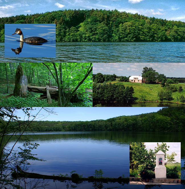
Zapraszamy Was na rowerową wycieczkę. Jej celem będzie keszobranie wzdłuż przyrodniczej ścieżki dydaktycznej prowadzącej do rezerwatu leśnego „Retno".
Długość naszej trasy wynosi ok. 10 km. Wycieczkę rozpoczniemy przy siedzibie Brodnickiego Parku Krajobrazowego w Grzmięcy a następnie zagłębimy się w południowo-wschodnie rubieże BPK. Jak wygląda ten rowerowy trail? Na początku, lecz nie po raz ostatni, przekroczymy most na Skarlance. Mijając nieco później pole biwakowe warto zwrócić uwagę na pomniki przyrody, dęby „Adama i Ewy". Za nimi skręcimy w prawo, by po raz kolejny przekroczyć Skarlankę i jej kolejny most. Skręcając za mostem w prawo ruszymy w kierunku osady Strzemiuszczek. Leży ona przy północnym brzegu jeziora florystycznego tej samej nazwie. Nasza ścieżka biegnie tu brzegiem lasu, co rusz prezentując piękne panoramy płytkiego jeziora Strzemiuszczek i wyrastającego za nim, częściowo zalesionego wzgórza (po zachodniej stronie jeziora).
Ok 2 km dalej skierujemy się drogą leśną na północny-wschód, wzdłuż malowniczego głębokiego jaru. Utworzył go ciek wodny wpływający do jeziora Strzemiuszczek. Przy leśniczówce Tęgowiec, jaką miniemy niebawem, warto odwiedzić oswojonego dzika.
Kierując się w prawo na południe do jeziora Retno dotrzemy jednocześnie do rezerwatu o tej samej nazwie. Rezerwat utworzony został w 1981 roku i ma powierzchnię 33,6 ha. Ochroną rezerwatową objęto las grądowy porastający zbocze przy zachodnim brzegu jeziora. Jest to najwyższe na Pojezierzu Brodnickim wzniesienie o wysokości względnej wynoszącej 40 m.
Nasza droga powrotna prowadzi nas w kierunku Grzmięcy. We wsi Gaj-Grzmięca warto rzucić okiem na niewielkie polodowcowe oczko wytopiskowe, powstałe z bryły martwego lodu.
Okolicę, przez którą przejeżdżamy, stanowi mozaika pól i lasów, wśród których rozciągają się jeziora rynnowe, charakterystyczne dla krajobrazu polodowcowego.
On the Retno-Trail / Photos BPK

We would like to invite you to a cycling tour along an educational trail leading to the Retno forest reserve. During the trip you will have the opportunity to both hunt for some geocaches and explore beautiful landscapes.
The trail is about 10 km long. Our trip begins near the Brodnica Landscape Park headquarters at Grzmięca; later we are going to head towards the south-eastern part of the Park. What is the trail like? At the beginning we are going to cross (for the first, but not the last time) a bridge over the Skarlanka River. Not much further there is a camping site with two nature monuments which are definitely worth seeing – Adam & Eve’s Oaks. After we are going to turn right and cross another bridge over Skarlanka, turn right one more time and head towards a settlement called Strzemiuszczek. It is located on the northern shore of a floristic lake also called Strzemiuszczek. From here we are going to follow a path leading along the edge of the forest; we will get many opportunities to admire the beautiful views of this shallow lake and of a partially forested hill in the west.
About 2 km further we are going to follow a forest road heading north-east, parallel to a picturesque, deep ravine. The ravine was formed by a watercourse which feeds into the Strzemiuszczek Lake. At the Tęgowiec forester’s lodge you can see a domesticated boar. Heading right, to the south from the Retno Lake, we will reach the Retno Nature Reserve. Its area is about 33.6 ha. It was created in 1981 in order to protect the oak-hornbeam forest (Carpinion betuli) which can be seen on the slope on the western shore. This is the highest elevation point (40 m) in the Brodnica Lake District. On our way back we are going to head towards Grzmięca. Near the village of Gaj-Grzmięca there is a small kettle lake, formed during the process of thawing of the dead ice – it is also a place worth visiting.
The mosaic of fields, forests and the so-called ribbon lakes which you can see around is a typical postglacial landscape.

Wir laden euch zu einem Fahrradausflug ein. Unser Ziel ist das Cachen entlang des didaktischen Wanderweges, der zum Landschaftsschutzgebiet „Retno“ führt.
Die Route ist ca. 10 km lang. Wir fangen am Sitz des Landschaftsschutzgebietes Brodnicki Park Krajobrazowy und tauchen direkt in den südöstlichen Teil des geschützten Gebietes ein. Wie wird die Rad-Route aussehen? Zuerst geht es über die Brücke auf Skarlanka. Danach fahren wir an einem Campingplatz vorbei, hinter dem es sich lohnt, die beiden Eichen, Naturdenkmäler „Adam & Eva“, in Augenschein zu nehmen. Gleich hinter den Bäumen biegen wir rechts ab, um wieder einmal Skarlanka über eine Brücke zu überqueren. Es geht direkt nach rechts, Richtung Ortschaft Strzemiuszczek. Diese liegt am Ufer eines Sees, der denselben Namen trägt.
Wir fahren entlang des Waldes, immer wieder eine wunderschöne Panorama des Sees Strzemiuszczek ergatternd und des dahinterliegenden Hügels (westlicher Seerand).
Zirka 2 km weiter werden wir Richtung Nord-Osten fahren, entlang eines trichterförmigen Tals, das das in den See abfließende Wasser formte.
Beim Forsthaus Tęgowiec lohnt es sich, das neben dem Haus wohnende und an Menschen gewohnte Wildschwein zu besuchen.
Wir biegen rechts ab und steuern auf den See Retno hin. Damit erreichen wir auch das Naturschutzgebiet „Retno“. Es existiert seit 1981, seine Fläche beträgt 33,6 ha – hier wird überwiegend der Heinbuchenwald geschützt, der die westlichen Seeufer bedeckt. Gleichzeitig ist es die höchste Erhebung der Brodnicki Seeplatte, knapp 40 m hoch.
Wir kehren zurück und fahren Richtung Ortschaft Grzmięca. In Gaj-Grzmięca lohnt es sich den Toteissee zu besuchen, eine der vielen Hinterlassenschaften der letzten Eiszeit. Das landschaftliche Mosaik bilden Felder und Wald und vor allem die typischen postglazialen Seen, die das skandinavische Eisschild hinterließ.
