This area was once the bottom of a shallow sea. This allowed the formation of sedimentary rock. Over time the gradual flow of water and heavy rain brought sediments to the bottom of this sea. The sediments became compressed and changed into sedimentary rock.
The material making up the sediments determine the type of sedimentary rock formed.
Types of sedimentary rock
1. Sandstone- made of small grains of the minerals quartz and feldspar.
2. Limestone- made from calcite deposited from the shells of sea animals.
3. Shale- made from clay sediments.
4. Conglomerate- made from large sediments like sand and pebbles cemented together by other dissolved minerals.
5. Gypsum- made up of sulfate material.
Types of erosion
Water Erosion
Water is the most important erosional agent and erodes most commonly as running water in streams. However, water in all its forms is erosional. Raindrops (especially in dry environments) create splash erosion that moves tiny particles of soil. Water collecting on the surface of the soil collects as it moves toward tiny rivulets and streams and creates sheet erosion.
Wind Erosion
Erosion by wind is known as aeolian (or eolian) erosion (named after Aeolus, the Greek god of winds) and occurs almost always in deserts. Aeolian erosion of sand in the desert is partially responsible for the formation of sand dunes. The power of the wind erodes rock and sand.
Ice Erosion
The erosive power of moving ice is actually a bit greater than the power of water but since water is much more common, it is responsible for a greater amount of erosion on the earth's surface.
Wave Erosion
Waves in oceans and other large bodies of water produce coastal erosion. The power of oceanic waves is awesome, large storm waves can produce 2000 pounds of pressure per square foot. The pure energy of waves along with the chemical content of the water is what erodes the rock.
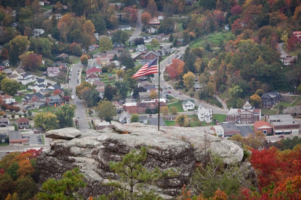
The Flag Rock Recreation Area is also known as “Norton’s Mountain Masterpiece”. It boasts 25 developed acres, which includes our Flag Rock Overlook. Aptly named after German immigrant Karl Matuszczyk, planted an American Flag on this large outcropping rock in the 1920’s. Flag Rock was dedicated in 1974 and opened on June 12 1976. It’s now off limits for climbing and can be safely viewed from the well maintained trail that goes to Flag Rock Overlook.
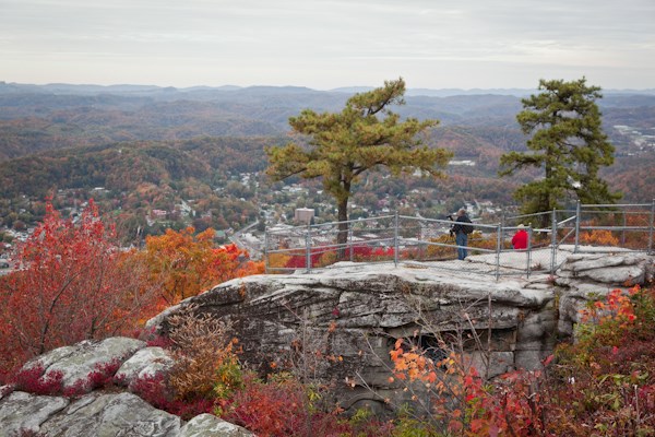
The view from the Flag Rock overlook affords a panoramic view of downtown Norton and the surrounding area. Numerous picnic tables are scattered throughout the park as well as two rental shelters that have large covered grill areas, fireplaces, electric and water. Restroom facilities are walking distance of the two covered rental shelters.
Also located at the two rental shelters are playground equipment as well as a field for other recreational activities, Rates for each of these covered shelters are $50.00 per day. Camping facilities are available in both upper and lower campgrounds. Both campgrounds have bathhouses with hot showers. With a breathtaking view of the mountains, these campsites are available on a first come first serve basis for only $15.00 per night.
The Flag Rock Recreation area is located on Rt. 619, Three miles above the City of Norton. For the avid walker, a hiking trail runs from the upper campground to the Norton Reservoir, which is seasonally stocked with rainbow trout. A trail to Legion Park is accessible from the upper restroom.
To get credit for the find, please email me the answers to the following questions.
1. What type of sedimentary rock is Flag Rock and the observation area on which you are standing and why do you think that?
2. Are the bedding planes(the surface that separates one layer rock from another) horizontal or do they appear to dip and if so, in which direction?
3. Have a look at the area, what erosion process do you believe formed Flag Rock and why do you think?
You are welcome to post photos of your visit to the site, but this is optional and not part of the logging requirements.
Thanks and enjoy!
FTF HONORS GO TO sewwatt, xenolith999
| I have earned GSA's highest level: |
 |