IMPORTANT: you will need a measuring tape and a calculator and you need to visit the site at low tide (see below for further information)
TO LOG YOUR VISIT:
Email us through our profile (Email, NOT message centre, thanks) the answers to the following questions:
1.At the given co-ords.
How many sea caves can you see infront of you from this loacation?
2.Go to cave furthest on the right hand side..
Using a tape measure, obtain the volume of the sea cave. Round your answer to the nearest cubic metre.
(Volume = Height x Width x Depth)
When taking the measurements, measure the widest points.
3.Go to the cave furthest on the left hand side.
What feature resulting from erosion and cave formation can you see in here? Include a description with your answer.
The following is optional and NOT a requirement to log your visit - photos from your visit are very welcome with your log. Feel free to upload photos if you like.
Do not wait to log your find. As soon as you have emailed the answers via our profile, please log the cache as found. Note: You will be contacted if no answers are received or if there are any issues with your answers.
Getting to Balscadden Bay
Howth is served well by both the DART and bus (31/a, 31b, 31n)
Access to Balscadden Bay is by means of a public footpath and steps, which lead down to a stoney beach.
As the geological interest is along the waterline, this earthcache can only be completed at low tide. You will need a measuring tape at GZ and a calculator later on. Click here for tide times:
To access the caves, you need to traverse the rocky shore line including some rock pools. Mind your step on slippy rocks. Sturdy footwear advised. See photo of terrain below.
Parking
There is room for a couple of cars to park opposite the access point to the beach (waypoint provided).
Introduction
Balscadden Bay is a small area of coastal cliffs with sea caves. The beach is of shingle, stone and sand and extends in length to approx. 150 metres. The remains of a small concrete jetty and boat winch (from a former water skiing club) and an extensive concrete platform/walkway with the remains of an old boat / storage shed and shelter area is still evident there.
Geology
The exposed coastal area along Balscadden Bay shows a faulted contact between the sedimentary rock type, limestone, and a mixture of metamorphic rocks. The contact between the two rock formations is a large fault zone. This contact can be seen as fault breccia (a type of altered and fractured rock that is produced along a fault line).
Sea Caves
Sea caves can form in a variety of rock types from igneous, sedimentary to metamorphic.
Igneous (from the Latin "ignis" - fire) Igneous rocks originates from molten matter deep inside the earth. Hot magma (liquid rock) comes up through cracks in the earth’s surface and fills other cracks or forms a layer on the surface. It then cools forming a very hard igneous rock.
Sedimentary (from the latin word meaning to settle) Sedimentary rock is formed from broken bits and pieces of different rocks. The three most common forms of sedimentary rock are limestone, sandstone and shale. Sedimentary rocks are very important as three quarters of the mass of the continents are covered with a thin layer of them, and concentrated within them are important resources such as coal, oil, groundwater and iron ore.
Metamorphic (from two greek words meaning change and form) Metamorphic rocks formed from igneous or sedimentary rocks that have been changed into a new rock. They form as a result of high pressures or temperatures. Sandstone gets changed into quartzite and limestone gets changed into marble. These new rocks are not as hard as igneous rock but can be very heavy. Slate, schist, gneiss and quartzite are other examples.
The three rock types are transformed into one another by processes of weathering and erosion, melting and exposure to heat and pressure.
Sea Cave Formation
A sea cave is a type of cave that is formed primarily from the wave action of the sea on the coastal cliff.
- For a sea cave to form, there must first be a weak spot in the cliff. In metamorphic or igneous rock, this is typically either a fault or dike. In sedimentary rocks, this may be a bedding-plane parting or a contact between layers of different hardness.
- Erosion occurs anywhere the waves crash against the cliffs. Where the cliffs contain areas of weakness, rock is eroded at a greater rate. As the sea reaches into the fissures(cracks) that develop, they begin to get wider and deeper due to the force exerted within the small space.
- As well as the power of the waves to carve out caves, there is the abrasive action of the sand and loose rock against the cliff when the tide is in.
- Rainwater also influences sea-cave formation. Acids in the soil above the cliffs leach from the soil and assist in weakening the rock within fissures.
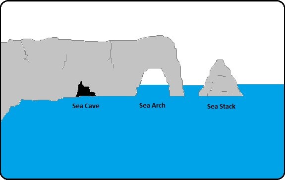
- Were the land juts out towards the sea and a sea cave has formed, the cave s continually eroded until a hole is cut throught to the other side and an arch is formed.
- Further erosion of the arch as it gows bigger causes it to collapse resulting in a stack which is left standing in the sea.
See diagram below which shows the stages of coastal erosion from sea cave formation to arch to stack.
 HAPPY EARTHCACHING!
| I am a proud |
 |
