During the last stage of the last Ice Age, called the Wisconsin glaciation, all but the extreme southwest corner of southwest Minnesota was covered by the Des Moines lobe of the Laurentide Ice Sheet. When the ice sheet melted around 12,000–14,000 years ago, it left behind a layer of loess (finely pulverized rock particles), windblown clay, and fine silt on top of the older sediments laid down by previous glaciations.
When glaciers retreat, they tend to leave piles of debris called moraines behind, which form when ice either plows glacial till to either side or the ends of the ice sheet, or simply drop material as the ice melts. Just west of Worthington is the long Bemis end moraine where a higher ridge was formed at the western edge of the Des Moines lobe. The slopes of that moraine are very gentle, but you can see where it is by all the wind turbines on it due to the higher wind speeds at the top of the moraine (locally, the moraine is called the Buffalo Ridge). The area of the two Okabena lakes and the town area is the Bemis ground moraine since the till was deposited under the ice and is characterized by the rolling hills and plains that stretch from the Iowa border northwest to Pipestone, MN.
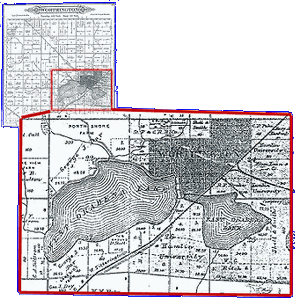
The Bemis ground moraine has pockets of thicker, denser water-impermeable clay in spots, and these pockets formed the many small lakes in the area. The lakes tend to be flat-bottomed because of the silty bottoms, and very shallow. A few are spring-fed from underneath, but most require surface runoff to remain full. At some point, two lakes formed in the area of Worthington, MN. They came to be known as West and East Okabena Lakes. The word “Okabena” is from the Santee Sioux language and means “home of the heron.” The lake is first noted on the map made by Joseph Nicollet in 1841, but curiously he did not mention the existence of two lakes.
In 1868, survey crews from the state came through the area looking for a route for the railroad and clearly plotted two distinct lakes on their map, separated by a small waterway or stream. The town of Worthington was founded in 1870 as a water stop on the Chicago, St. Paul, Minneapolis, and Omaha Railway.

A geological survey in 1882 again shows East Okabena, but there seems to now be an outlet on the south side of the lake that doesn’t appear in the 1868 map.
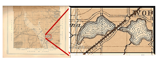
The last know mapping of the east lake came on an 1888 plat map of the Worthington area. The southern drainage is also shown on this map. It’s possible that this overflow channel may have been dug or widened after the 1868 map was made, starting the drainage of the lake.
In 1889-1890, the Burlington Railroad (later called the Rock Island Railroad) was built across dry lakebed on the north side of East Okabena. Starting in late 1899, a second drainage ditch was constructed to drain East Okabena to the east end of Lake Ocheda. This appears to be the end of the lake as a large body of water. A 1914 plat map of the area refers to the "formerly East Okabena lake" and notes that it is "Now dry, having been drained".
In 1940, Highways 59 and 60 were rerouted to go around the city, through the former lake area. It has since been reconstructed to be a four lane highway in just the last few years.
Signs of the former lake are still visible in the area and even from the air. An interactive map can be found here. Dry lakebeds are usually very flat, and major tree growth is confined to the original shorelines. You are now standing near the old shoreline near Buss Field park and soccer complex. The second waypoint brings you to a monument on a nearby part of the lakeshore, on East Lake Boulevard.
To receive credit for this EarthCache, please email me (through the link in my profile) the answers to the following questions. Please include the name of the cache in your email.
- Looking to the east, describe what you see starting at your feet and going to the playground. Are you standing on the former beach or the lake bottom, and how do you know?
- Now look to the south, across the soccer fields toward the Highway 59/60 grade. Describe what you see. Can you pick out the southern shore beyond the highway grade? Why do you think it is the old shoreline?
- Move to the second waypoint and the monument. How does the area just behind the monument resemble that described in question 1? Once again, are you on the shore or bottom?
The hours of Buss Field are listed as “sunrise to sunset” so please respect them. Parking is available on the street outside the park and along East Lake Boulevard by the monument, so no park entry is required to answer the questions.
Sources:
Roadside Geology of Minnesota, Richard W. Ojakangas, Mountain Press Publishing, 2009.
Lake Okabena History