The Susquehanna River is located in the northeastern United States. At 464 miles it is the longest river on the east coast that drains into the Atlantic Ocean. And with its watershed it is the 16th largest river in the United States. And the longest river in the continental United States without commercial boat traffic. It flows through three states: New York, Pennsylvania & Maryland. It forms from two main branches with the “North Branch”,which rises in upstate New York, near Cooperstown is about 100 ft wide from bank to bank, at a elevation of 479 ft above sea level, & regarded by federal mapmakers as the main branch. The West Branch of the Susquehanna rises from a spring near Carrolltown, PA with a elevation of 609 ft above sea level, it then passes through Lock Haven and Williamsport before turning south to join the main stream near Northumberland in Central Pennsylvania it is 1500 ft across & a elevation of 450ft above Sea level. The river drains 27,500 square miles, including nearly half of the land area of Pennsylvania. The drainage basin (watershed) includes portions of the Allegheny Plateau region of the Appalachian Mountains cutting through five water gaps in the lateral mountain ridges north of Harrisburg in a broad zigzag course to flow across the rural heartland of southeastern Pennsylvania and northeastern Maryland. The river empties into the northern end of the Chesapeake Bay providing half of the Bay's freshwater inflow. Before the end of the last ice age, the Susquehanna was a much longer river. The Chesapeake Bay constituted its lower valley before it was flooded by rising waters at the conclusion of the Pleistocene, a formation known as a ria.
To Claim This Cache As A Find, Please E-mail me the answers to the following questions: Please be sure to include the name of the earthcache in your email.
1.The Susquehanna is the most flood prone river in the U.S. with major floods occurring every 20 years. What effects would this flooding produce on marine life in the Chesapeake Bay? Why?
2.What two sources of energy are dominant on this part of the Susquehanna?
3.What is the approximate distance to the West Bank of the Susquehanna River from the posted coordinates?
4.OPTIONAL: Please take a picture and post it of you/your group & GPS with the river in the background.
Log the cache, I will only respond if you have incomplete logging requirements.
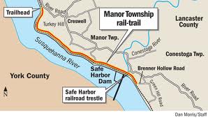
Enjoy sweeping views of the Susquehanna River along this 5.25 mile trail which begins at the base of Turkey Hill Point and ends near the Safe Harbor Dam. The trail is 12 feet wide compressed stone with elevated observation decks, natural waterfalls, a restored caboose, picnic tables, benches and restrooms along the way. This section follows an abandoned right of way of the Enola Low Grade Railroad, one of several branch lines of the Pennsylvania Railroad.

Caches along this section of the trail have been hidden by members of the LOST group. LOST is the Lancaster Organization for Seeking Tupperware.
Visit our website lostcachers.com or our profile L.O.S.T. for more information on our group.