
 Overnight trips to Mosquito Lakes require a permit from the Mineral King ranger station. Reservations are recommended. The lakes are close to 10,000 feet high, so be prepared. The trail to the lakes end at the first lake and cross-country travel is needed to reach the higher lakes.
Mosquito Lakes are a series of lakes in a glacially cut valley of the Southern Sierra Nevada Mountains. This area is near the southern limits of the recent glaciations. Glaciers filled the valley during the Tioga (14-25 thousand years ago) and Younger Tahoe (42-50 thousand years ago) glaciations, and at least one pre-Tahoe glaciation. During those periods, glaciers carved out the glacial landforms in the local granite.
While the glacier flowed down through the valley, it picked up pieces of rock and incorporated them into ice. Likely these pieces of rock came from the excavation of the cirques (See Mosquito Lakes – A series of Cirques) that now form the lakes. Some of these rocks were were large enough to form these features, chatter marks (USGS Glacier Terminology). While others were tiny to powder, forming glacial polish (see Mosquito Lakes – Glacial Polish)
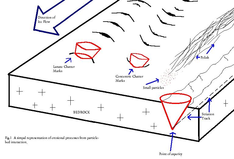 Chatter marks are formed by a slight bouncing of a larger rock against the bedrock. This slight bouncing gouges out series of small crescents in the bedrock. USGS Glacier Terminology. There are typically a series of chatter marks in a row and the direction of travel can be determined by drawing a line through the crescents. Chatter marks can be either concentric or lunate. Concentric chatter marks have the open part of the crescent upstream; while the lunate marks have the open part downstream.
Logging requirements:
Send me a note with :
- The text "GC4QPX2 Mosquito Lakes – Chatter Marks" on the first line.
- The number of people in your group (put in the log as well).
- Are there enough chatter marks here to determine a direction? If so, what direction was the glacier flowing, assuming downhill has not changed?
- What kind of chatter marks are present, concentric or lunate?
The above information was compiled from the following sources:
- http://libwiki.mcmaster.ca/clip/index.php/Main/Chattermarks
- Thomas Juon and Dak Helentjaris, Last modified May 17, 1999, http://gemini.oscs.montana.edu/~geol445/hyperglac/eroproc1/
Trial listing approved by
Yosemite National Park