The Missouri Department of Conservation is not liable for your safety.
Follow all posted signs within the park, and cross NO property lines.
Missouri Conservation areas are closed from 10PM till 4AM.
Landscape changer – Woods fork creek in Busiek state forest and wildlife area
This earthcache is designed for you to immerse yourself in nature  , while learning about geology. You will probably get wet and you will probably be doing some bushwhacking, depending on the time of your visit.
This creek can at times be really moving, and at others be completely dry.
If you feel unsafe crossing the creek - Don't - come back a different day to complete this earthcache.

Source: personal photo
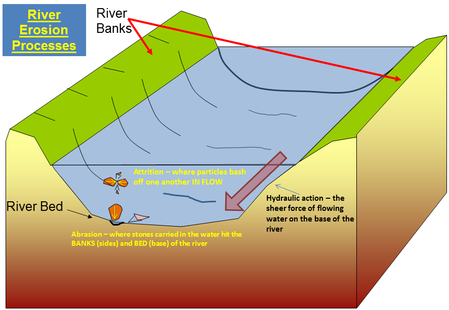
Erosion
Rivers and streams are moving bodies of draining water, which have a tremendous amount of force. Because of their strength, streams and rivers can cause great amounts of erosion.
Dirt and dust are carried away in the water of the river, leaving only pebbles and rocks. The rocks are constantly smacking into one another, as the force of the river moves them about. This causes them to be continually breaking into smaller and smaller pieces.
Rivers have been known to carve deep canyons in the bedrock in only a few hundred thousand years.

Source: http://library.thinkquest.org/C0110238/erosion.gif
Source: http://www.coolgeography.co.uk/GCSE/AQA/Water%20on%20the%20Land/Processes/Erosion%20Processes.png
Deposits
As rivers carry dust, pebbles, and rocks downstream, this material is eventually deposited at some locations further down. These deposits form at bends in a river, as well as in locations where rivers dump water into lakes.

Source: http://www.berkeley.edu/news/media/releases/2009/10/images/invitro1_h.jpg
Fossils
This is the Missouri State fossil Delocrinus missouriensis

Source: personal photo
This is not the Missouri State fossil, it is Brachiopods

Source: http://www.onegeology.org/extra/kids/images/fossils/Brachiopod2.jpg
There are other kinds of fossils, but these are the most common found in Missouri
**Logging requirements**
DO NOT POST ANSWERS IN YOUR LOG.
Send the following answers to me via email.
While at “erosion observation” answer the following questions
- What is the number one erosional feature happening here? (It’s a no brainer)
- What is the current force/rate of erosion? Take a leaf and place it 10 feet up stream, count the seconds it takes to travel 10 feet.
- Find a small rock, one of which you can pick up, take your knife or keys and try to scratch the surface. If the rock scratches what color is the scratch? (i.e. White, red, black) I really tried to get the needed permission to allow you the opportunity to perform a chemical test. So this is the only way for you to tell that you have a limestone rock in your hands. If the rock did scratch it’s about a 99% chance that it’s limestone.
- Find a fossil; there are lots of rocks with fossils in them, in the stream. What kind of fossil did you find?
- What is the dimensions of your fossil, size, (not = circle, square, ect) (i.e. 10’X2”X4”)
- Standing at “erosion observation” what is the elevation here?
Cross the creek and start the climb up the hill towards waypoint “Top”. As you climb the hill make observations of the rocks you are climbing.
- Are there differences between the rocks as you progress up the hill? (i.e. = is the rock “cliffy” at certain areas versus other elevations? Is the rock different in color at different elevations? What about the texture of the rock, is it smooth closer to the top and jagged at the bottom, or vise versa? ECT) (note, I do expect your observations in your email to me)
- Based on your observations you have made while climbing up the hill what other erosional force (other than water) is at play here? (i.e. gravity, wind, abrasion, ect)
- What is the elevation at waypoint “top”?
- What is the difference between the two elevation readings you have done AND how many years do you think erosion toke to create this difference?
| I have earned GSA's highest level: |
 |
The above information was compiled from the following sources: