HISTORY
Remnant shoreline of Lake Iroquois
Glacial Lake Iroquois existed at the end of the last ice age approximately 13,000 years ago. It was essentially an enlargement of the present Lake Ontario. It was approximately 30m (~100ft) above the present level of Lake Ontario. The lake created a ridge that runs just above and parallel to Davenport Road. This ridge, about 2 km inland from the shore, is known as the Iroquois Shoreline.
Davenport Road
All of Toronto below Davenport Road was once under water. First Nations peoples beat a path at the base of the escarpment of the old shoreline to use as an overland route between the Humber and Don Rivers; (a portion of the route connecting Montreal to Niagara). This trail was the longest First Nations trail to exist in Ontario and had several earlier names, including "Plank Road," "Bull Road," and "the new road to Niagara."
Davenport Road continued to be an important passageway, for French fur traders in the 1600's, and for the early European settlers who arrived in this area in the 1790's. After the founding of York in 1793, the trail began to appear on maps of the area. The first house to be built on top of the ridge was built by the European settler Ensign John McGill in 1797, a home which he named ‘Davenport,’ (near today’s Earlscourt Park). This was named after Major Davenport, another local officer, and is the origin of the area's name (the name Davenport is of Norman French origin: Dauen-port, meaning "the town on the trickling stream").
The major streams flowing over the Iroquois shore between the Humber and Don Rivers were, from west to east, Garrison Creek, Taddle Creek, Castle Frank Creek, and Silver Creek. Today they are nearly all confined to underground sewers, but in the past they were a source of water and fish for those who first lived here. Small waterfalls occurred as the creeks tumbled over the Iroquois bluff and at places the creeks broadened to form small ponds. The only pond left, a remnant of Taddle Creek, is in Wychwood Park.
The Davenport trail was paved in 1833, and was converted into a roadway by a private company that built and maintained the road with the improvements to be paid for by tolls that all users of this roadway were required to pay. Tollkeeper's cottages were constructed every few kilometres. There were five tollgates built between the Humber and Don Rivers. Formerly known as Tollgate #3, the Tollkeeper’s Cottage at Bathurst and Davenport is believed to be the only early tollhouse still surviving anywhere in Canada.
The area was primarily a farming community until 1861, when the Northern Railway opened a line just south of here, at Dupont St. The Railway built a station just north of Davenport Road on the west side of Caledonia Park Road, which was demolished and replaced with the St. Clair West Station in the 1930s. The Railway attracted industry to this area, and a small village named ‘Davenport’ emerged. In 1909, Davenport was annexed by the City of Toronto and residential development began shortly thereafter.
Davenport Road is unique in that it does not follow Toronto's standard street grid pattern. It currently runs from Yonge Street to Old Weston Road. Bathurst Street and Davenport Road, looking southeast – 16 January 1914.
Check out this website for more interesting old photographs of Davenport Road: http://www.blogto.com/city/2013/09/what_davenport_road_used_to_look_like_in_toronto/
Staircases
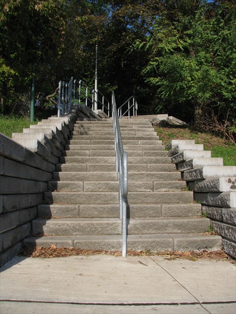
Over the years, several sets of stairs have been built to assist residents with getting up and down the hill that is the former edge of Lake Iroquois, which is 15-23m high (50 to 75ft). These stairs mark the ancient shoreline and follow the escarpment’s contours. They begin at Davenport Road, and take pedestrians up to the residential neighbourhoods adjacent to St. Clair Avenue. There are 7 sets of stairs located at Earlscourt Park, Via Italia, Glenholme, Hillcrest Park, and Spadina. Looking south from the top of each staircase takes the eye not only down towards Davenport Road, but across the whole downtown and city skyline. When you’re at the top of the stairs, imagine yourself at the top of the escarpment, looking down at the ancient lake.
CACHE JOURNEY
This multi-cache will take you to the 7 staircases that originate on Davenport Road in five unique locations. Each waypoint will take you to either the bottom or top of a staircase and your job will be to count the steps! Record the number of steps in each staircase as you will need these in order to calculate the coordinates to the final. A calculator might be handy! The entire journey (from the first to the last waypoint) is approximately 3.5km and took me about 50 minutes to walk. The starting point is at the corner of Caledonia Park Rd and Davenport Rd. (N 43° 40.275 W 079° 27.071) You will travel west to east along the north side of Davenport, until reaching the final waypoint at Spadina Rd. and Davenport Rd. near Casa Loma.
As you walk along Davenport Rd., you will pass by many other interesting places, including Regal Road Public School, Alcoa Bakery, the Davenport Library, Wychwood Park, The Tollkeeper's Cottage, the TTC’s Hillcrest Yards, George Brown College, and Casa Loma. There is a dedicated bike lane that runs along Davenport throughout the entire route.
If you wish to include photos in your log, please do so! You may take photos of the staircases, from the top or bottom, and any other interesting things you find along the route.
Please note that there is no winter maintenance of the first set of stairs at Earlscourt Park and snow cover may make it difficult to count the steps. All of the other sets of stairs are generally well-maintained during winter.
Enjoy the walk, and don’t forget to look down and admire the views once you reach the top of each staircase. Happy counting! 
STAGES/WAYPOINTS
STAGE 1 (a & b) - Earlscourt Park Stairs
Earlscourt Park is 12.6 hectares and is attached to one of the largest community centres in Toronto, Joseph J. Piccininni. This community centre has an outdoor and indoor swimming pool as well as many other programs. The park consists of a soccer field, a multi-purpose sports field and track, a baseball diamond, an outdoor rink, four tennis courts, a basketball court, a volleyball court, an off-leash dog park, a children's playground, a wading pool, a gazebo and many walking paths. It is also home to many outdoor festivals that occur throughout the summer months.
At Caledonia Park Rd., the ancient Lake Iroquois shoreline swung north along the edge of Earlscourt Park to Hwy. 401 as it skirted around the flooded Humber River valley. There are two sets of stairs going up to the park, both starting at Davenport Rd. 1a will take you to the first set of steps to climb, and 1b will take you to the top of the second set of stairs you will climb down. Record the number of steps in each set of stairs separately!
STAGE 2 - Via Italia Stairs
Via Italia is a street in the heart of Corso Italia, considered Toronto's second Italian neighbourhood, after Little Italy on College Street. There is also a significant Latin American and Portuguese community in the area. Corso Italia developed in the 1950s as Italian immigrants, and people from College St.’s Little Italy started to move up to St. Clair. The neighbourhood includes numerous cafés, clothing shops, shoe stores, restaurants, food markets, gelaterias, and bakeries. Another interesting feature is the abundance of corner stores buried in these residential streets, a diminishing thing in Toronto. Corso Italia hosts several annual festivals, including the Corso Italia Toronto Fiesta in July.
The Via Italia Stairs links this community to Davenport Rd. It is the least known about and visited of the staircases on Davenport Rd. The coordinates will bring you to the bottom of these stairs.
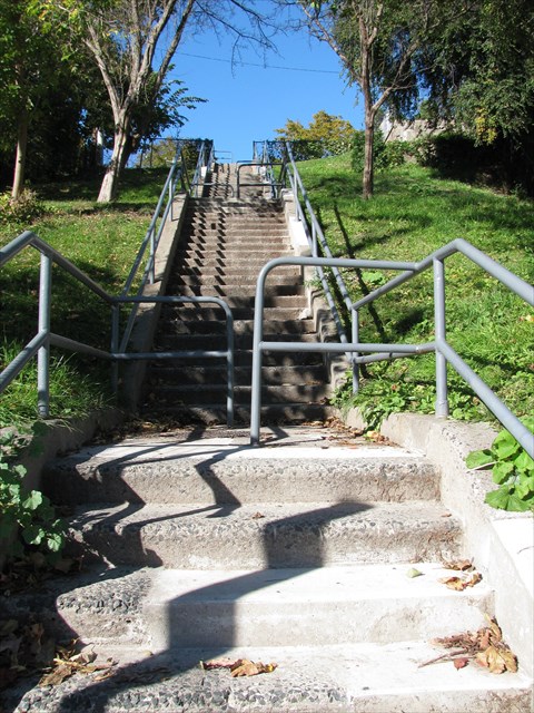
STAGE 3 – Glenholme Steps
These coordinates will take you from the bottom of Glenholme Steps to the intersection of Regal Road and Glenholme Avenue. Regal Heights neighbourhood has many distinguishing characteristics including large and beautifully crafted homes, winding tree-lined streets, and an elevation that offers many home owners amazing views of the Toronto skyline. The soil in Regal Heights is largely made up of heavy clay and before farmers tilled the land, strands of white oak and pine covered the landscape. A handful of century old white oak trees can still be found in the neighbourhood, including one near the top of the steps that is about 150-200 years old. Towering Norway maple trees, planted by the city in the 1920s, shade the front yards of many homes. During the term of Toronto Mayor George Geary (1910-1912), streets were laid out and construction started on two schools that still exist today; Regal Road Public School and Oakwood Collegiate Institute.
Garrison Creek also helped shape the local landscape. Springmount, Alberta and Mount Royal Avenues were built on top of or close to the actual creek bed. Garrison Creek had two branches which met just north of Davenport Rd. and crossed the trail at Mount Royal Ave., cutting a deep ravine to the south. Garrison Creek was treated as a garbage dump in the 19th century and to protect public health, it was put in an underground sewer pipe between 1880 and 1914. “Garrison Creek” has been engraved on the sidewalks in certain places in the neighbourhood to indicate where the creek used to flow. You will pass by one at Davenport Rd. and Mount Royal Ave.
These steps are large and wide with railings on both sides and are generally well maintained in winter. Davenport Road was subject of a 2009 photo essay; the staircase is mentioned in a plaque at the St. Clair streetcar’s Glenholme Ave. stop.
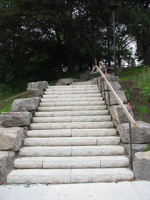
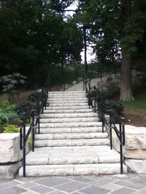
STAGE 4 (a & b) - Hillcrest Park Stairs
Hillcrest Park, as the name suggests, is a park on a hill. This 2.1-hectare park includes a children’s playground, a wading pool, a baseball diamond, a basketball court, four lighted tennis courts shared by the Wychwood Tennis Club, an off-leash dog park, a drinking fountain, a dog dish fountain and a community garden.
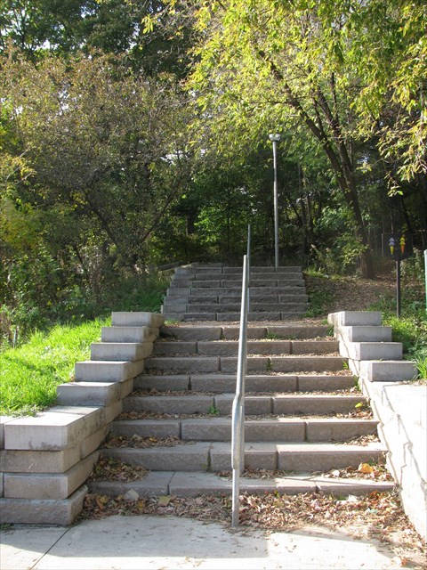
There are two sets of stone steps beginning at Davenport Road that lead to the top of the escarpment. These steps were recently constructed to replace the single wooden staircase that weaved its way among the trees to the top of the escarpment. These new steps are wide. well-defined, well-lit and they offer a quicker way of getting to the top of the park from Davenport Road. Among the trees, you can still see parts of the old wooden staircase that remained. The first set of coordinates (4a) will bring you to the bottom of the first set of stairs to go up and 4b will take you to the top of the second set that you will go down, ending up at the corner of Davenport Rd. and Christie St. Again, record the number of steps in each set of stairs separately!
STAGE 5 – Spadina/Casa Loma Stairs or Baldwin Steps
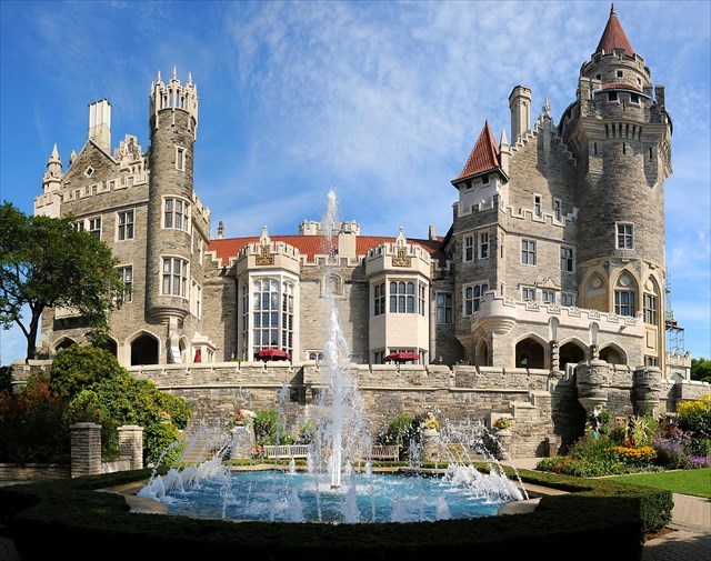 Casa Loma (Spanish for Hill House) is a Gothic Revival style house and gardens that is now a museum and landmark. Sir Henry Mill Pellatt (born to British parents in Kingston, Ontario on January 6, 1859) commissioned Canadian architect E.J. Lennox to design his lifelong dream of a medieval castle on the brow of a hill overlooking Toronto. Begun in 1911, it took 300 men nearly three years to complete and cost $3.5 million at that time.
At 98 rooms, it was the largest private residence in Canada. Notable amenities included soaring battlements, an elevator, an oven large enough to cook an ox, two vertical passages for pipe organs, a central vacuum, two secret passageways in Sir Henry's ground-floor office and three bowling alleys (never completed). An underground tunnel connects Casa Loma to the Hunting Lodge and to the stables (garage, potting shed, stalls, carriage room and tack rooms) just a few hundred feet north of the main building. Casa Loma has five acres of gardens.
Sir Henry Pellatt enjoyed Casa Loma for less than ten years before financial misfortune forced him to abandon his home in 1923. The city seized Casa Loma in 1933 for $27,303 in back taxes. The castle was extremely run down and the city was motioning for the castle to be demolished. In 1937, however, it was leased by the Kiwanis Club of Toronto (currently known as the Kiwanis Club of Casa Loma) and opened to the public for the first time as a tourist attraction. Today, Casa Loma is undergoing a 15 year exterior restoration. It is one of Toronto's most popular tourist attractions and hospitality venues.
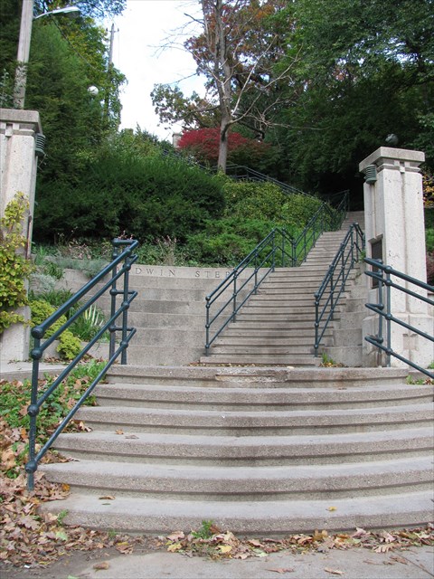
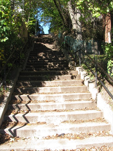
At 23 meters high (75ft), this is the steepest part of the old escarpment. A set of wooden steps were built to allow people to move through the area; these steps were later replaced with a more permanent set of steps in 1913. In 1987, the City of Toronto rebuilt the steps to those present today. They follow the original zigzag path up the escarpment. At this time, the steps were given the name “Baldwin Steps” to commemorate Robert Baldwin, a former premier of Ontario, whose family were the first landowners of the area. The Baldwins named their land ‘Spadina,’ after their house on the ridge. The name is a contraction of Ishapahdenah, an Indian word meaning “a rise in the land.” The steps are also famous for appearing in the Scott Pilgrim graphic novels and their film adaptation, Scott Pilgrim vs. the World. The coordinates will bring you to the bottom of these steps. Once you reach the top, you will be able to calculate the coordinates to the final as you admire the spectacular view. Hope you enjoyed the journey!
How to Calculate Coordinates for the Final
You should have 7 numbers; each is the total number of steps for each staircase.
The coordinates to the final are: N 43° AB.CDE W 079° FG.HIJ
North
- Stage 3 minus Stage 2, and then multiply by 10. This number is AB.
- Add Stage 1a and Stage 1b. Subtract 26. This number is CD.
- Stage 4b minus Stage 4a, and then add 1. This number is E.
West
- Add ALL 7 numbers (stages) together. Subtract 26. Then, turn the number backwards. This number is FGH.
- Take the first two digits in the number for Stage 5. This number is IJ.
That’s it! It should be a short (approximately 10 minute walk) to the final. Good luck!
Other Caches Directly Along the Route:
References
http://en.wikipedia.org/wiki/Glacial_Lake_Iroquois http://torontoist.com/2012/03/prehistoric-toronto-glacial-lake-iroquois/ http://www.janeswalk.net/index.php/walks/canada/toronto/stairs-lake-iroquois/ http://abitmoredetail.wordpress.com/tag/glacial-lake-iroquois/ http://www.torontoplaques.com/Pages_DEF/Escarpment.html http://www.sidespacegallery.com/TorontoUpstairs.htmlhttp://whaton.uwaterloo.ca/waton/s992.html http://www.torontoplaques.com/Pages_ABC/Baldwin_Steps.html http://www.torontoplaques.com/Pages_DEF/Davenport_Road.html http://www.yelp.ca/biz/hillcrest-park-toronto#query:parks%20with%20stairs http://www.yelp.ca/biz/earlscourt-park-toronto http://www.toronto.ca/parks/prd/facilities/complex/514/ http://en.wikipedia.org/wiki/Davenport_Road http://en.wikipedia.org/wiki/Davenport,_Toronto http://www.torontoneighbourhoods.net/neighbourhoods/midtown/davenport/history http://www.blogto.com/city/2013/09/what_davenport_road_used_to_look_like_in_toronto/ http://en.wikipedia.org/wiki/History_of_Toronto http://neighbourhoodwalks.wordpress.com/2011/09/21/corso-italia/ http://en.wikipedia.org/wiki/Corso_Italia_(Toronto) http://www.toronto.ca/parks/prd/facilities/complex/79/ http://www.toronto.ca/parks/prd/facilities/complex/79/ http://wikimapia.org/674657/Hillcrest-Park http://en.wikipedia.org/wiki/Baldwin_Steps http://www.casaloma.org/about.history.gk http://en.wikipedia.org/wiki/Casa_Loma http://www.49st.com/venue/casa-loma-1#info http://en.wikipedia.org/wiki/Regal_Heights