Vernon Springs is a scenic area located in Northeast Iowa, just south of Cresco. The Prairie's Edge Nature Center is located in Vernon Springs Park and has snowshoes and cross-country skis available during the winter months. The Prairie Springs Nature Trail, a 2.5 mile trail for hikers and bikers, runs from Cresco to Vernon Springs. In the winter, there are designated trails in the park groomed for snowshoes and cross-country skis. The park also is home to the Turkey River Campground, a modern camping facility, located up a winding road in the woods a little further from the Turkey River. The Vernon Springs Mill Pond is a popular place for fishing, swimming, boating, and even water skiing. There are also snowmobile trails in the park.
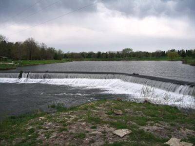
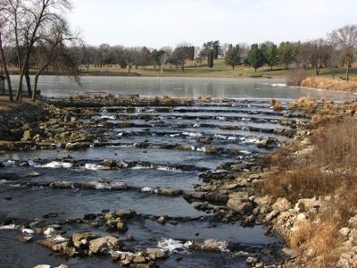
Vernon Springs is also the site of Iowa's first Rock Arch Rapids, built in 2010. The low head dam here was converted to a rapids resulting in the reconnection of the Turkey River to the lake upstream and the river’s two main tributaries in Howard County. Aquatic species including Small-mouth Bass, Walleye and Northern Pike can now travel the entire length of the river. This connection allows access to deeper water in the mill pond for winter survival and access to feeder streams for spawning.
The new structure eliminates the recirculating currents often found at low head dams that can cause drownings, while maintaining water elevation for a popular lake. This structure also provides needed stabilization for the dam that was in a dilapidated condition following many years of flood damage. The rock arch rapids was created using large limestone blocks and smaller fill limestone to form a 350 foot long slope from the bridge to the top of the low head dam. Each rock was GPS’d in place for best fit and efficiency! The dam is actually still there though only the top cap is readily visible. This project represents the first major dam mitigation in the state of Iowa.
Below is a photo of the original Vernon Springs Dam and the Rock Arch Rapids built in 2010.

You can validate your puzzle solution with certitude.