ENGLISH
GENERAL FOR THE MOUNT AIGALEO
The mountain Egaleo is in Attica and is the natural boundary of Athens , Piraeus and Western Attica.The maximum altitude is 468m.
It has smooth peaks, were in-between there are created small plateaus and valleys which are crossed by numerous dirt roads.
The peaks are: in the North "Kukos" 468m, in Southeast "Kokkinovrachos" 268m, and in the west "Mountain Scaramanga" 359m
The mountain Egaleo was covered entirely by dense pine forest that has been harvested by local residents during the 2nd World War in order to survive. Today, only the North - NorthWest side of the forest is preserved.
The visitor can observe pines, olive trees, holly, wild thyme, as well as foxes, turtles, hedgehogs, too many partridges, small hawks, etc.
The majority of the dirt roads of mountain Egaleo can be driven by mountain bike, motorbike on/off, and 4X4 vehicles throughout the year.
On the north side of the mountain a paved road leads to the top of the mountain.
From the top of the mountain (37° 59.683' N 23° 37.481' Ε) you can drive the dirt roads with a courtesy car, however I do not recommend it due to my love to "natural scrolling."
The CACHE
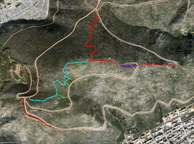
The cache is located on a plateau on top of the "kokkinovrachos" of Mount Egaleo.
With view at the bay of New Iconium, the peaks of "Xerxes" and in the background the Bay of Scaramanga.
My cyclists friends jokingly have named the hill Fere (from feregios) due to the creation and maintenance of a network of bike and hiking trails in specific hill. (see pic2)
So when you reach the end of the dirt road to reach the cache, follow the path "High Voltage"! You will understand from far away why we call it so :-)
The container is a middle-sized cylindrical tube initially contains logbook, geocaching decalration in Greek and English and some small items for trade.
Access to the hill
A) From the top (37° 59.683' N 23° 37.481' Ε) as described above
B ) On the east side, as described in the cache Mt.Egaleo - The Snail Rock.
C ) From the cemetery Keratsiniou and after walking through paths and dirt roads.Park your car at 37° 58.933' N 23° 36.321' E and use the "secret exit" at 37° 58.889' N 23° 36.440' E
If you select this option, ask at your entrance what time the main entrance is closing.
Trails and dirty roads near the cache from the openstreetmap HERE.
ΕΛΛΗΝΙΚΑ
ΓΕΝΙΚΑ ΓΙΑ ΤΟ ΟΡΟΣ ΑΙΓΑΛΕΩ
Το όρος Αιγάλεω βρίσκεται στην Αττική και αποτελεί το φυσικό σύνορο Αθηνών, Πειραιώς και Δυτικής Αττικής. Το μέγιστο υψόμετρο είναι 468μ. 'Εχει ομαλές κορυφές που ανάμεσά τους δημιουργούνται μικρά οροπέδια και λαγκάδια τα οποία διασχίζονται από πλήθος χωματόδρομων.
Οι κορυφές του είναι : Βόρεια ο "Κούκος" 468μ. , Νοτιο-Ανατολικά ο "Κοκκινόβραχος" 268μ και Δυτικά "Βουνό Σκαραμαγκά" 359μ.
Το όρος Αιγάλεω ήταν καλυμμένο εξ ολοκλήρου με πυκνό πευκοδάσος το οποίο υλοτομήθηκε από τους κατοίκους της περιοχής κατά τον 2ο Παγκόσμιο Πόλεμο για τις ανάγκες τις επιβίωσής τους. Σήμερα σώζεται δασωμένη μόνο η Βόρεια - Βορειοδυτική του πλευρά.
Ο επισκέπτης μπορεί να παρατηρήσει πεύκα, αγριελιές, πουρνάρια, άγρια θυμάρια, όπως επίσης αλεπούδες, χελώνες, σκαντζόχοιρους, πάρα πολλές πέρδικες , μικρά γεράκια κ.α.
Το πλήθος των δασικών του όρους Αιγάλεω είναι προσβάσιμοι με Ποδήλατο Βουνού, μηχανή on/off (το παπάκι μου), και οχήματα 4Χ4 όλη την διάρκεια του έτους.
Από την βορεινή πλευρά του βουνού ανεβαίνει ασφαλτοστρωμένος δρόμος μέχρι την κορυφή.
Από εκεί (37° 59.683' N 23° 37.481' Ε) μπορείτε και με ένα επιβατικό όχημα να μπείτε στους δασικούς. Δεν το προτείνω λόγω της αγάπης μου στην "φυσική μετακίνηση"
Η ΚΡΥΠΤΗ
Η κρύπτη είναι τοποθετημένη σε ένα πλάτωμα της κορυφής του "Κοκκινόβραχου" στο όρος Αιγάλεω.
Με θέα τον κόλπο του Νέου Ικονίου, τις κορυφές του "Ξέρξη", και στο βάθος τον κόλπο του Σκαραμαγκά.
Αστειευόμενοι οι φίλοι μου ποδηλάτες έχουν ονομάσει τον λόφο Φερέ (από το feregios) λόγω της δημιουργίας και συντήρησης από εμένα ενός δικτύου ποδηλατικών και πεζοπορικών μονοπατιών στον συγκεκριμένο λόφο.(δες φωτο2)
Έτσι όταν φτάσετε στο τέλος του δασικού για να φτάσετε στην κρύπτη, ακολουθήστε το μονοπάτι "High Voltage"! Θα καταλάβετε από μακρυά γιατί το ονομάζουμε έτσι. :-)
Η κρύπτη είναι ένας μεσαίου μεγέθους κυλινδρικός σωλήνας που αρχικά περιέχει logbook , geocaching decalration στα ελληνικά και στα Αγγλικά και μερικά μικρά αντικείμενα για ανταλλαγή.
Πρόσβαση στον λόφο
Α) Από την κορυφή (37° 59.683' N 23° 37.481' Ε) όπως περιγράφεται πιο πάνω
Β) Από την ανατολική πλευρά , όπως περιγράφεται και στην κρύπτη Mt.Egaleo - The Snail Rock.
Γ) Από το νεκροταφείο του Κερατσινίου και μετά περπάτημα μέσω μονοπατιών και δασικών. Παρκάρετε το αυτοκίνητό σας στο 37° 58.933' N 23° 36.321' E και χρησιμοποιήστε την "μυστική έξοδο" στο 37° 58.889' N 23° 36.440' E
Εάν διαλέξετε αυτή την λύση ρωτήστε στην είσοδο την ώρα που κλείνει η κεντρική είσοδος.
Μονοπάτια και δασικοί δρόμοι κοντά στην κρύπτη από το openstreemap ΕΔΩ.
 !!! ΧΡΗΣΙΜΑ ΚΑΙ ΕΛΛΗΝΙΚΑ !!!