Waypoint 1 is an exposed piece of the rock at the top of the hill; notice the weathering and the exposure of minerals. Examples of minerals that are found in this area are plagioclase which has a white to translucent crystal appearance and biotite which is a mica that is black or dark green.
At the Waypoint 2 coordinates, along the hillside you just walked above, a thick layer of crinkle-folded, yellow-weathering gneiss overlies a layer of quartzite and amphibolite. At the contact between the quartzite and the gneiss, a large piece of the quartzite has fallen out creating a small cave. Look for the tiny lavender garnets in the quartzite; they will not look like the stones used for jewelry, instead they are deformed due to metamorphosis.
So how was this formed? Here is some geological history:
The State of Delaware is located within two major geologic provinces, the Atlantic Coastal Plain and the Piedmont. Most of the state lies within the Coastal Plain; it is only the hills of northern New Castle County that lie within the Piedmont. Piedmont means foothills. Delaware's rolling hills, which rise to over 400 feet above sea level, are a part of the foothills of the Appalachian Mountains.
The rocks at the surface in the Piedmont today are old, deformed, metamorphic rocks that were once buried in the core of an ancient mountain range. This range formed early in a series of tectonic events that built the Appalachians between about 543 and 250 million years ago. During an early event, called the Taconic orogeny, an offshore chain of volcanoes collided with the ancient North American continental margin to push up a gigantic mountain range that was as tall as the Alps or the Rockies of today. Geologists date the Taconic orogeny between 470 and 440 million years ago.
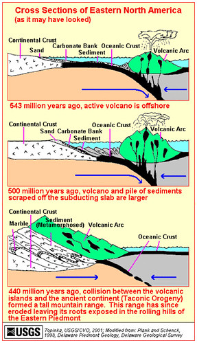
The Taconic orogeny is important to our understanding of the geology of Delaware, because during this event, the rocks of Delaware's Piedmont were deeply buried under miles of overlying rock and metamorphosed by heat from the underlying mantle. Since that time, rivers and streams have carried the erosional products, mostly sand, clay, and gravel, from the mountains onto the Atlantic Coastal Plain and continental shelf. As the mountains wear down, the buried rocks rebound and rise to the surface. Thus what we see in the Piedmont today are old deformed metamorphic rocks that were once buried deep within an ancient mountain range.
To log this cache send me an email me with the answer to these three questions: 1)At Waypoint 1, which mineral do you think has more exposure? 2) At Waypoint 1, in addition to human intervention, why do you think the minerals are now exposed? 3) At Waypoint 2, how tall, wide, and deep is the cave opening?
Feel free to post pictures of yourself at either waypoint.
PLEASE DO NOT POST ANSWERS IN YOUR LOG
Special thanks to USGS and DGS for images and information!