Sinkhole formation.
Sinkholes are common where the rock below the land surface is limestone, carbonate rock, salt beds, or rocks that can naturally be dissolved by circulating ground water. In the Blyvooruitzicht and Carletonville areas the rock that dissolves to cause the sinkholes are dolomite. The chemical composition of dolomite is: CaMg(CO3)2. Dolomite dissolves in acidic water, forming underground cavities and caves such as those at the Sterkfontein caves in Gauteng and the Cango caves near Oudtshoorn, Western Cape, South Africa. Sinkholes are dramatic, because the surface land usually stays intact until there is not enough support.

Figure 1: The formation of sinkholes
Then, a sudden collapse of the land surface can occur, resulting in a sinkhole appearing. Dolomite is used in the manufacture of cement and fertilizers to neutralise acidic soils. There are also other types of sinkholes, which will not be discussed here. Sinkholes may be formed gradually or suddenly, and are found worldwide. Dolomite rock is found over a wide area in the North-west and Gauteng provinces of South Africa as shown in the diagram below. It stretches from the far West rand to the far East rand, of the Witwatersrand, encircling the granite dome between the Witwatersrand and Pretoria. Shown as "Gauteng" in figure 2.
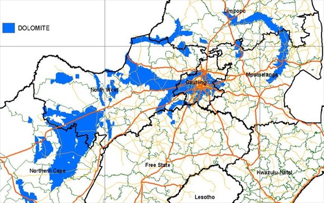 Figure 2: The distribution of dolomite in South Africa
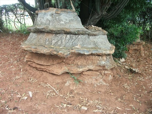
Some very good examples of dolomite rock can be viewed in front of the main gate of the Rockland high school in Blyvooruitzicht. Dolomite with its grey colour is often referred to as ‘Elephant Skin’ rock. The reason for this is seen in the photograph below:
What causes sinkholes?
Many sinkholes form when acidic rainwater dissolves limestone or similar rock beneath the soil, leaving a large void that collapses when it's no longer able to support the weight of what's above, whether that be an open field, a road or a house. These are called "cover-collapse sinkholes," and it would appear this is what happened in the Blyvooruitzicht and Carletonville areas, where the ground beneath a 7 storey screening, crusher and sorting plant and house suddenly gave way in 1962 and 1964 respectively.
Almost all sinkholes are associated with a change in ground water regime. The vast majority of sinkholes are induced by human activity, such as ground water abstraction or leaking utility services.
What caused the sinkholes in Blyvooruitzicht?
To find an answer to this question, one needs to look at mining in the Far West Rand (FWR) and the lowering of the water table by mining activities.
As early as 1911, attempts to mine gold in the FWR failed initially, as large volumes of water from dolomite aquifers flooded the newly-sunken shafts. It was only in 1934 that the development of cementation technology made the sinking of shafts successful through water bearing dolomite. Gold mines in this area, such as Blyvooruitzicht, and later West-Driefontein were, in their heyday, the world’s richest gold mines.
West-Driefontein GM applied to the government for permission to dewater overlying dolomitic compartments in an effort to reduce the ever increasing pumping costs that many mines incurred in more than 3-km deep mine workings. In 1964 the Government finally granted permission to GM to dewater 2 dolomitic compartments. It might not be proved officially, but dewatering had taken place prior to 1964 without Government consent.
Approximately 1,2 km of dolomitic limestone overlies the Far West Rand gold reefs southwest of Johannesburg, South Africa. This karst aquifer is partitioned into several groundwater compartments by predominantly north–south trending syenite dykes. Karst topography is a geological formation shaped by the dissolution of a layer or layers of soluble bedrock, usually carbonate rock such as limestone or dolomite. Prior to mining, the primary water flow was westwards, decanting over dyke boundaries as a succession of springs along the Lower Wonderfontein Spruit (creek).
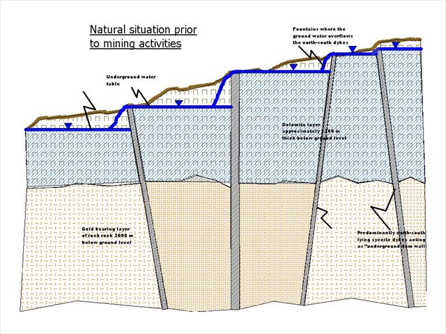 Figure 3
Dewatering of the overlying dolomitic aquifer, for safety and economic reasons by deep gold mining operations, caused the water levels of four compartments to drop and their respective springs to dry up.
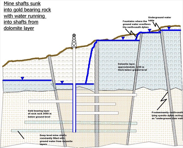 Figure 4
By pumping out more water from the underlying mine void than was naturally replenished in the dolomite, the groundwater was lowered by up to 1000 m in places. This caused a massive acceleration of karst-related ground instability in the form of sinkholes with dire consequences to residents and the local infrastructure.
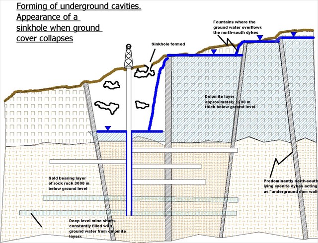 Figure 5
The potential of dolomite instability is related to the karstic nature of the dolomite. If the dolomite is karstic and there are caverns which have been dewatered by mine pumping, on recharge, as water moves through the caverns, wad which has accumulated due to weathering of the dolomites and which contributes to support, may be eroded. This will create potentially unstable situations. Once the caverns are completely filled with water, stability will increase. The photograph shows karstic rock exposed in the Centurion area, south of Pretoria, Gauteng, South Africa. Note the typical ‘Elephant skin’ rock (dolomite). As a point of interest, the decision to build the Gautrain railway line underground or above ground in the Centurion area was influenced by these karstic formations. It was deemed safer to keep the route of the line above ground.
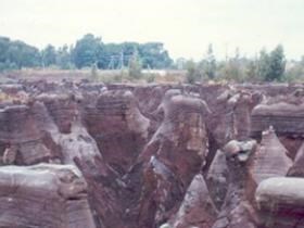
Figure 6: Dolomite in the Centurion area
The result of the dewatering by mines in the FWR.
The most catastrophic sinkhole on record occurred in 1962 at West-Driefontein GM, where a 7-storey-high screening, crusher and sorting plant disappeared completely, trapping 29 workers, none of whom could be rescued, followed by a sinkhole in 1964 at Blyvooruitzicht village killing a family of 5. A cache, “3 August 1964 – GC18RV4” is placed at the site where the family of 5 died. It is recommended that the site of this cache be visited.
Over the past 50 years or so, well over 1000 sinkholes have formed in the area. To reduce the significant volume of storm water that flowed into sinkholes making the sinkhole situation worse, several attempts to fill sinkholes were made to fill them with a mixture of waste rock and tailings material. In a number of instances, the tailings suddenly disappeared overnight, giving an idea of the size of these sinkholes.
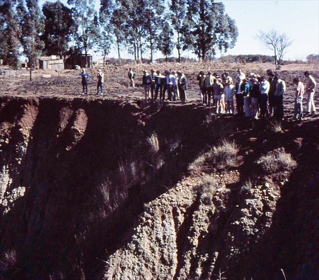
I was fortunate to have been lectured by the late Prof. ABA Brink who was a pioneer in establishing the science of Engineering-geology in South Africa. Two of his favourite subjects were the sinkholes at the FWR and the significance of the pebble marker in engineering-geology. Every year he took his students to view some of the sinkholes in the FWR. In the photograph below, taken during 1970, a group of engineering students can be seen at the opening of a sinkhole in the Blyvooruitzicht area. Note Prof. Brink in the middle pointing to some feature at the sinkhole.
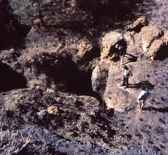
The picture below shows another sinkhole in the Blyvooruitzicht area. Note the “funnel” through which all the material disappeared into the cavern below. Some of the braver students were lowered through the funnel by means of a hoist hanging from a tripod. The size of the cavern was so big that normal flashlights could not light up the walls of the cavern.
References:
Various publications on the internet:
- Dewatering and rewatering due to mines in the FWR.
- Ground Movement as a Result of Dewatering in the Far West Rand (FWR) Area of Johannesburg Resulting in the Formation of Sinkholes and Dolines by Solomon Phogole, and Antoine Mulaba-Bafubiandi. A paper at the International Conference on Mining, Mineral Processing and Metallurgical Engineering (ICMMME'2013) April 15-16, 2013 Johannesburg (South Africa).
- The future of the dolomitic springs after mine closure on the Far West Rand, Gauteng, RSA. - C.J.U. Swart, A.R. James, R. J. Kleywegt,E. J. Stoch.
- The risks associated with mines in dolomitic compartments by T.A. Ngcobo*. Paper written on project work carried out in partial fulfilment of BSc Eng (Mining) degree.
- Typical Methods for Forecasting Karst Collapse in China - Yan Meng, Jianling Dai, Long Jia, Mingtang Lei, Institute of Karst Geology, Guilin, 541004, P.R. China.
- Appropriate Development of Infrastructure on Dolomite: Guidelines for Consultants - Department of Public Works.
- Website: http://www.gautrain.co.za/construction/2010/03/overview-dolomitic-geology-centurion/
In order to qualify to log this cache, you need to answer the following questions and send the answers to the cache owner using the cache owner's geocaching profile. Any logs for which answers have not been received by the cache owner will be deleted.
1. At the published coordinatesof this earth cache you will find a corroded device that was used during the period of the collapse of sinkholes in Blyvooruitzicht. Describe how you think this device was used to predict the possibility of a sinkhole appearing? The device is in the red circle and is shown on the inset of the photograph.
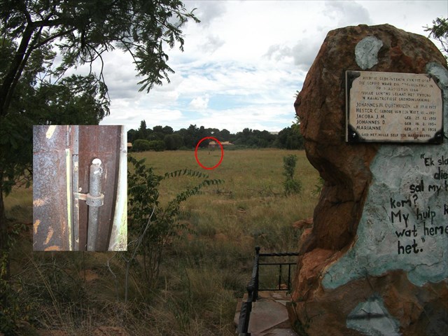
2. Three letters and two numbers appear on the inside of the “door” of the device referred to in question one. Name these.
3. What other common name related to an animal is used for dolomite?
4. What is the motto on the badge of the school at WP (S26 24,169 E027 22,929) where some examples of dolomite rock are displayed?
5. Although not compulsory, it would be wonderful to obtain some pictures of your visit to the site or to the examples at the school. No spoilers of the letters and numbers in the device, please.
FTF: Thrips.