The Ohio River is responsible for much of the growth and development of the city of Huntington, West Virginia. The movement of settlers and goods along the river prior to the advent of rail and highway transport found the area that is now Huntington to be a valuable stopping point. Holderby's Landing at present day Huntington was established in 1775, when it was still a part of the colony of Virginia. Guyandotte, at the confluence of the Guyandotte and Ohio Rivers, now a community in East Huntington, is believed to have been settled as early as 1609. When Collis P. Huntington brought the C & O Railroad to the area in the 1870s a rail link was established between the Chesapeake Bay and the Ohio River. This made Huntington an important part of the nation's transport with well developed river and rail facilities.

While the Ohio River has been important in the success of Huntington, it has also cause some of the area's worst disasters. A major flood in 1913 resulted in major damage and loss of life all along the Ohio River's 981 mile length from Pittsburgh, PA to Cairo, IL. However, the 1937 flood was the worst ever seen in the region in which homes, businesses, factories and farms in a every state along the river's path was inundated. The flood displaced over one million people from their homes, and nearly 400 lives were lost. It is estimated that over $500 million in damages resulted from the flood which translates to over $7 billion in today's dollars.
January 1937 had the perfect recipe for disaster along the river. There had been an unusually heavy snowfall in December 1936 followed by an unusually warm period in January 1937. In addition, to the warm weather in January, heavy rain fell for 19 straight days. The rapidly melting snow and runoff from rain overwhelmed the Ohio River watershed filling the floodplain along the river's path.
The Ohio River crested at 69.45 feet on January 27, 1937 in Huntington, WV. This crest is more than 19 feet above the official designation of “flood stage” and is three feet higher than the 1913 flood. During the flood, residents of Huntington escaped to the city's hills to the south. Churches and relief agencies combined to feed and house the city's residents displaced by the flood. Following the flood, the city set to clean up, rebuild and mourn the loss of five lives lost in the flood.
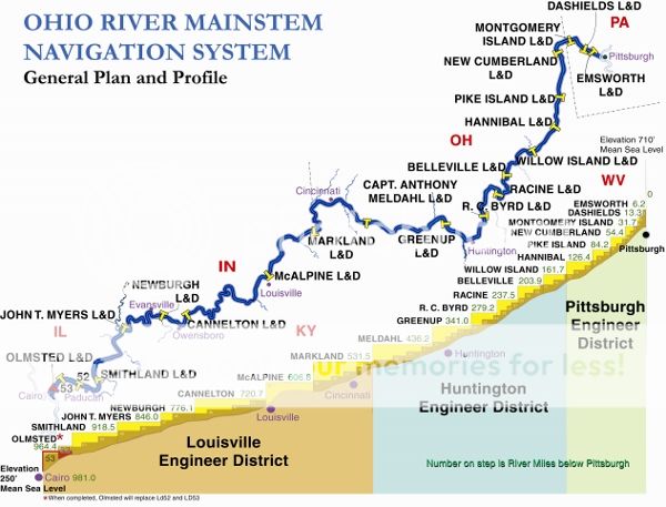
As a result of the 1937 flood, the US Army Corp of Engineers developed a plan to decrease the likelihood of floods on the Ohio River resulting in such catastrophic loss of life and property. One part of the plan is flood control through a series of locks and dams along the river. This system assured safe navigation of barges and other vessels during low water periods as well as the ability to control the flow of water to ease flooding along the Ohio River. Another tool of the Corps of Engineers was the development of flood walls around cities in low flood plains along the river.

The city of Huntington sold bonds to pay for a flood wall and levied a “flood wall tax” to pay for the bonds. The flood wall around Huntington was begun in 1938 in three stages, one around the city itself, one around Guyandotte to the east and the third around the Westmoreland part of the city. The Huntington section was completed in 1940 and construction was started in Westmoreland. However, US involvement in World War II caused the effort to shift to the Guyandotte/Altizer area to protect the strategically important International Nickel Company (INCO) where alloys were manufactured that were important in the development of advanced weaponry. The flood wall around the city of Huntington was completed in 1943 and is estimated to have saved a quarter of a billion dollars and countless lives since then.
Recent criticism has focused on the unattractive appearance of the flood wall and the interference of the barrier to commerce and recreation on the river. In 1984, Harris Riverfront Park was opened to provide Huntington's citizens and visitors with entertainment and recreational opportunities. Concerts, festivals, boat races and other events throughout the year take advantage of the beauty and power of the Ohio River.
To claim this Earthcache please email the answers to the questions below to the cache owner prior to logging a find. Logs with spoilers in the text or photos will be deleted without warning as will the logs of of cachers who have not emailed correct responses to the required questions.
1. Go to the flood gauge at the posted coordinates. Find the height of the 1937 flood (69.45 feet). Assume that the river has risen to the 69.45 foot record height of the 1937 flood. How many feet would the river have to rise to breach the height of the floodwall?
2. Assume the water has risen to street level at the bottom of the flood gauge. How many additional feet would the river need to rise to reach the 69.45 record of 1937?
You are welcome to post photographs of the beautiful Harris Riverfront Park, the flood wall or the city of Huntington. However, spoiler photos showing the flood gauge or the plaques will result in your log being deleted.
This Earthcache is 100% handicap accessible and can be completed without ever leaving your car. However, please take the time to visit this beautiful park in downtown Huntington.
Much of the information in this listing was provided by local Huntington historian and retired reporter/editor of the Huntington Herald-Dispatch.
This Earthcache has been placed as part of the Cabell County Geotrail to showcase the great places to visit in and around Huntington, West Virginia.
Special thanks to ScienceCacher for creating this Earthcache.