 |
Le Grotte di Frasassi |
|
Considerate il più grande complesso ipogeo in Europa le Grotte di Frasassi si caratterizzano per un insieme di percorsi sotterranei della lunghezza di circa 30 km, suddivisi in 8 livelli geologici differenti. Le grotte sono aperte al pubblico solo per 1,5 dei 30km complessivi.
Il percorso turistico consiste in una passeggiata di circa un’ora accessibile a tutti ad una temperatura di 14 gradi costanti tutto l'anno. Consigliamo scarpe comode e, durante i mesi estivi, una felpa. Per i visitatori con mobilità limitata l’accesso è possibile fino all’inizio della seconda sala, la Sala 200.
Lasciare la macchina al Waypoint Parcheggio, qui vi è anche ubicata la biglietteria in cui acquistare il biglietto di ingresso alle grotte. Da qui dovete proseguire verso l’ingresso delle grotte prendendo l’autobus compreso nel biglietto o a piedi.
Considera che la visita alle grotte è a pagamento.
Le grotte
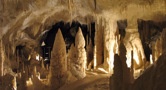
La prima grotta che si presenta è quella denominata ABISSO ANCONA, maestosa e considerata una delle più grandi al mondo (dimensioni: 180m di lunghezza, 120m di larghezza e 200m di altezza). La guida sottolinea la difficoltà dell’occhio umano nel percepirne le dimensioni e la prospettiva, aiutando l’escursionista a valutarne l’ampiezza della sala facendone un paragone con il Duomo di Milano. Nel fondo della cavità si puo' osservare un caotico ammasso di blocchi, risultato dei movimenti distruttivi e dei crolli che si sono verificati nel corso dei millenni e che hanno dato origine all'Abisso Ancona. Un particolare che colpisce l'attenzione del visitatore sono le "Cascate del Niagara", una colata di calcite allo stato puro. Al centro della sala domina l'imponente gruppo di stalagmiti millenarie denominate "I giganti". Valutato il diametro (2m - 5m) e l'altezza (1,50m - 20m), possono essere sicuramente considerate le più importanti stalagmiti della grotta. Da questo luogo, osservando la cupola dell'Abisso Ancona, è possibile vedere l'apertura naturale attraverso la quale, i primi speleologi si sono calati all'interno della grotta scoprendo questo maestoso complesso ipogeo.
Si arriva così alla SALA 200 che prende il suo nome proprio dalla lunghezza della grotta. All'inizio ci sono delle concrezioni bizzarre, chiamate "Castello delle Streghe". Sulla volta, appena percettibile, una stalattite lunga 7,40 metri, chiamata la "Spada di Damocle". Di fronte al visitatore (nella direzione del senso di marcia), domina solitaria e imponente una stalagmite (chiamata Obelisco), che ha per base una enorme roccia caduta dell'alto. Ha un'altezza di circa 15 metri compreso il basamento.
Il percorso inizia a restringersi fino ad arrivare al GRAN CANYON, chiamato così perchè da esso si attraversano grandi crepacci. Alla base di queste grandi fessure scorre dell’acqua che si trova al livello del fiume Sentino. Qui incontreremo le "Canne d'organo", un gruppo di stalattiti parallele che sembrano formare un organo e che, se colpite delicatamente danno suoni diversi. Ai bordi di un laghetto numerosi esili stalagmiti che danno forma alla preziosa "Sala delle Candeline".
Continuando il percorso turistico si giunge alla SALA DELL'ORSA chiamata così per il masso che ricorda vagamente la forma di un'orsa.
Il giro prosegue e termina attraverso la SALA PAGLIAI e la SALA INFINITO. Presenta imponenti esempi di condotte forzate verticali attraverso le quali risalivano le acque sulfuree.
 |
| Mappa del percorso turistico |
NB: le foto all’interno delle grotte sono vietate, per favore rispettate questo divieto per non rovinare le grotte stesse.
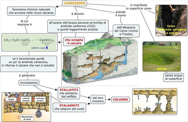
Carsismo
Il termine carsismo indica l'attività chimica esercitata dall'acqua, soprattutto su rocce calcaree, sia di dissoluzione sia di precipitazione. La parola ha origine dal nome della regione dove inizialmente questo fenomeno è stato studiato, il Carso. E' un altopiano roccioso calcareo che si estende nel nord-est dell'Italia attraverso la Slovenia occidentale e l'Istria settentrionale.
Il carsismo generalmente si articola in due fasi (dissolutiva e costruttiva) che possono alternarsi all'infinito, a seconda di come varia l'equilibrio della saturazione in H2O della CO2 nella reazione chimica reversibile fondamentale seguente:
-
La fase dissolutiva è operata dallo scorrimento superficiale o ipogeo di precipitazioni rese acide dall'anidride carbonica presente nell'atmosfera
-
La fase costruttiva si ha quando l'acqua sotterranea, arricchita (fino alla saturazione) di carbonato acido di calcio, sfociando per esempio nell'atmosfera di una grotta, lo rilascia sotto forma di carbonato di calcio insolubile.
I complessi fenomeni chimici di dissoluzione e precipitazione in ambiente carsico possono essere chimicamente così sintetizzati:

Contrariamente al carbonato di calcio [CaCO3] praticamente insolubile, il bicarbonato di calcio [Ca(HCO3)2] è solubile in acqua in ioni Ca2+ e HCO3- che vengono asportati dall'acqua dilavante. L'evoluzione del carsismo procede in profondità creando cavità ipogee, arrestandosi solo al contatto con rocce non sottoposte, per contenuto mineralogico, al fenomeno di dissoluzione carsica. Le grotte sono senza dubbio le forme più conosciute di carsismo sotterraneo.
In condizioni particolari e molto rare altri meccanismi possono anche svolgere un ruolo importante. L'ossidazione di solfuri che portano alla formazione di acido solforico può anche essere uno dei fattori di corrosione in formazione carsica proprio come avviene a Frasassi con le acque sulfuree del torrente Sentino.
 |
| Schema riassuntivo del carsismo |
Il carsismo a Frasassi
Nella struttura di Frasassi sono poco diffuse forme carsiche di superficie, mentre raggiunge grande sviluppo il carsismo sotterraneo. Le grotte si sviluppano in una fascia altitudinale compresa tra i 200 ed i 500 metri; esse presentano un tipico andamento ramificato, con gallerie prevalentemente orizzontali, anche di grandi dimensioni, impostate sui principali sistemi di fratturazione; le gallerie carsiche sono disposte su almeno 4 livelli principali, la cui evoluzione è collegata alle fasi di approfondimento della rete idrografica superficiale. I livelli inferiori, tra i 200 ed i 300 m di quota, si sono probabilmente originati nel Pleistocene medio e nel Pleistocene superiore. I corsi d'acqua, ostacolati dal complesso montuoso di Frasassi, hanno formato, all'inizio del Pleistocene, un grande lago all'altezza di Pianello di Genga e filtrando in profondità attraverso le fratture della roccia calcarea, hanno raggiunto i sottostanti depositi Evaporitici Riabliani costituiti da salgemma, gessi e livelli bituminosi. Attraverso millenni le acque ristagnanti nell'area di Pianello-Genga, agendo in profondità e sottoposte a notevoli pressioni idrostatiche, hanno provocato la soluzione degli Evaporiti Riabliani, sciogliendo salgemma e gesso, scomponendo quest'ultimo in bicarbonato di calcio e acido solfidrico (acque sulfuree).
La circolazione di acque sulfuree all'interno di un massiccio calcareo causa significativi effetti sia nell'ambiente fisico, sia in quello biologico. Nelle grotte di Frasassi la più evidente conseguenza è rappresentata dalla formazione di gesso, presente anche in depositi molto potenti, distribuiti nei vari piani carsici. La formazione del gesso non rappresenta solamente un interessante fenomeno mineralogico, ma è intimamente connessa con le reazioni di solubilizzazione del calcare. Lo sviluppo del carsismo profondo è infatti dovuto proprio alle reazioni di ossido-riduzione che coinvolgono lo zolfo nella parte superficiale della falda freatica. Le principali reazioni che intervengono nella corrosione della roccia possono essere schematizzate in:

e possono svilupparsi principalmente in prossimità della superficie freatica, dove le acque sulfuree vengono a contatto con l'ossigeno presente nell'atmosfera della grotta o nelle acque percolanti. Il processo è attivo sia nella parte superiore della zona freatica, dove i solfati sono continuamente allontanati in soluzione, sia nella zona vadosa, dove si ha formazione di gesso [CaSO4]. L'anidride carbonica liberata nella reazione [2] può generare una addizionale corrosione carsica [3]. Il gesso di neoformazione si presenta principalmente sotto forma di poltiglie bianche, microcristalline, che rivestono le pareti. Prove sperimentali hanno consentito di verificare che attualmente la corrosione della roccia ad opera delle acque sulfuree procede al ritmo di circa 6 mm/100 anni; questi valori sono almeno 10 volte superiori a quelli misurati sulla superficie terrestre e relativi alla corrosione carsica operata dalle acque piovane. L'azione delle acque sulfuree spiega quindi l'elevato grado di sviluppo del carsismo raggiunto a Frasassi rispetto alle altre strutture calcaree umbro-marchigiane.
 |
| Schema del sistema di grotte a Frasassi |
LOG:
Prima di registrare il ritrovamento rispondete alle seguenti domande inviandomi un messaggio tramite il mio profilo. I log senza permesso verranno cancellati.
Domande:
- Alla fine del tunnel artificale, prima di entrare nell’Abisso Ancona, la guida si fermerà e vi mostrerà la mappa delle grotte dandovi inoltre alcune norme comportamentali da tenere all’interno della grotta stessa. Qui c’è pure una targa di marmo a ricordare la scoperta della Grotta Grande del Vento. Che data vi è impressa? Nota che non è la data reale in cui è avvenuta la scoperta.
- Visitando le grotte la guida vi avrà fatto notare svariati tipi di concrezioni come le stalattiti, le stalagmiti, le colonne, le colate calcitiche ed i laghetti cristallizzati. Spiegane la differenza.
- Qual'è il colore predominante delle concrezioni? Spiega il motivo per cui si ha questo colore in base anche a quanto hai letto nel listing.
Ci sono altri colori? Se si, a cosa sono dovuti secondo te?
- Secondo te, oltre all’età, cosa fa si che ci siano stalagmiti e stalattiti di diametro e altezza diversa? (Pensa alla vastità degli ambienti in cui ti trovi).
- Nella "Sala dell'Orsa" vedrai un sasso che nella forma ricorda un orso. Osservalo ma non toccarlo, ti sembra liscio o ruvido? Secondo te cosa può aver modellato il masso originale dandogli questa forma?
- Lungo il percorso di visita è stato installato anche un acquario che riproduce l’ecosistema acquatico delle Grotte di Frasassi. Che animaletti potete vedere?
- Aggiungi una foto di e del tuo GPS lungo il tunnel d'ingresso.

 |
Frasassi Caves |
|

Considered the largest hypogeum complex in Europe, the Frasassi caves consist of 30 km underground paths, divided into 8 different geological layers.
The caves are open to the public for only 1.5 of the 30 km, a walk of about 1 hour accessible to everybody at a temperature of 14 degrees all the year round. We recommend to wear comfortable shoes and, during summertime, a sweatshirt. For visitors with limited mobility, access is possible until the begin of the second room, the Hall 200.
Leave your car at the Parking Waypoint where there is also the ticket booth for the caves. From here you have to go to the entrance of the caves by bus, which is included in the ticket price, or by foot.
Please note that there is an entrance fee to visit the caves.
The caves
The first cave that you’ll see is called ABYSS ANCONA, it’s considered one of the largest in the world (dimensions: 180m long, 120m wide and 200m high). The guide highlights the difficulty of the human eye to perceive the size and perspective, it helps making a comparison with the Cathedral of Milan. In the bottom of the cavity you can observe a chaotic cluster of blocks, a result of the destructive movements and collapses that have occurred over thousands of years and which gave rise to the Abyss Ancona. One detail that strikes the visitor's attention are the "Niagara Falls", a casting of pure calcite. In the center of the hall there's the impressive group of stalagmites known as "The Giants". Valuating their diameters (2m - 5m) and heights (1.50m - 20m), they can certainly be considered the most important stalagmites in the cave. From this place, observing the dome of the Abyss Ancona, you can see the natural opening through which the first speleologists were lowered into the cave discovering this extraordinary underground complex. Then we arrive in the HALL 200, which takes its name from the length of the cave. At the beginning the visitor will find some strange concretions called "Witch Castle". On the vault, barely perceptible, a stalactite 7.40m long, called the "Sword of Damocles" . In front of the visitor there’s a single and impressive stalagmite, called “Obelisk”. This stalagmite has, as a basement, a wide rock fallen from the ceiling and it is about 15 m high. Then we met the GRAND CANYON, so called for the presence of clefts. At the base of these large cracks water’s flowing at the same level of the river Sentino. Here we will meet the "Organ Pipes", a group of parallel stalactites that form an organ and if they’re lightly touched, they give different sounds. On the shore of the lake there are a large number of thin stalagmites that form the precious "Candle's hall", Continuing the tourist trail you reach the URSA’S HALL called so for a rock which resembles vaguely to a shape of a bear. The tour continues and ends by PAGLIAI HALL and HALL INFINITY. There are impressive examples of vertical penstocks through which the sulphurous waters went up.
|
| Tourist route map |
NOTE: Taking pictures inside the caves is forbidden, please respect this prohibition to keep the caves safe.
Karst
The term karst indicates the chemical activity done by the water, especially on limestone rocks, both of dissolution and precipitation. The word originates from the name of the region where this phenomenon has been initially studied, the Karst Plateau. It is a limestone plateau region extending from northeastern Italy through southwestern Slovenia and Istria. The karst is generally divided into two phases (dissolutive and constructive) that may alternate perpetually, depending on how the balance of saturation of CO2 in H2O varies in the basic reversible chemical reaction.
-
The dissolutive phase is operated by the sliding surface or underground rainfall made acidic by carbon dioxide in the atmosphere
-
The constructive phase is when the underground water, enriched (up to saturation) of calcium hydrogen carbonate, flows for example in a cave, releases it in the form of insoluble calcium carbonate.
The complex chemical phenomena of dissolution and precipitation in karst environment can be chemically synthesized as follows :
At the contrary of calcium carbonate [CaCO3] that’s practically insoluble, calcium bicarbonate [Ca(HCO3)2] is soluble in water. The evolution of the karst proceeds in depth by creating underground cavities, stopping only when in contact with rocks not subjected to the phenomenon of karst dissolution. The caves are without any doubts the most well known forms of underground karst. In very rare and special conditions other mechanisms may also play an important role. The oxidation of sulfides, leading to the formation of sulfuric acid, can also be one of the factors in karst formation and corrosion; just like in Frasassi with the sulphurous waters of the river Sentino.
The karst in Frasassi
In Frasassi the karst in surface is not widely spread, while there’s a great underground karst formation. The caves are located in a strip between 200 and 500 meters, they have a typical branched structure, with mainly horizontal galleries and very large as well. Karst tunnels are placed on at least 4 main levels, their evolution is connected to the phases of deepening of the hydrographic network surface. The lower levels, between 200 and 300 m above the sea level, have probably been origin in the Middle Pleistocene and Upper Pleistocene.
The rivers, obstructed by the Mountains of Frasassi, formed, at the beginning of Pleistocene, a wide lake next to Pianello di Genga. Getting deep through the breaks of calcareous rocks they reached the ”Evaporitici Riabliani” deposits below, made of rock-salt , chalk and bituminous levels. Through the millenniums the stagnant water in Pianello-Genga's area, operating deep and subjected to great Hydrostatic pushes, caused the solution of “Evaporiti Riabliani”, melting rock-salts and chalk, splitting the latter in calcium bicarbonate and sulphurous acid (sulphurous water). The circulation of sulphurous water in a limestone massif, cause significant effects both in the physical environment and in the biological one. In the caves of Frasassi the most obvious consequence is the formation of gypsum, which is present in big deposits, distributed in various karst plains. The formation of gypsum is not only an interesting mineralogical phenomenon, but it is connected with the reactions of dissolution of limestone. The development of deep karst is in fact caused by the reactions of reduction-oxidation involving sulfur on the surface of the water table. The main reactions involved in the corrosion of the rock can be summarized in:
and they can mainly happen in the vicinity of the water table, where the sulphurous waters are in contact with the oxygen present in the atmosphere of the cave or in the percolating waters. The process is active both in the upper part of the phreatic zone, where the sulfates are continuously removed in solution, and in the vadose zone, where there there’s the formation of gypsum [CaSO4]. The carbon dioxide liberated in the reaction [2] can generate an additional karst corrosion [3]. The gypsum just formed occurs mainly in the form of white and microcrystalline poultices, which cover the walls of the caves. Some experiments show that the current corrosion of the rock by the sulphurous waters proceeding at a rate of about 6 mm/100 years. This value is at least 10 times higher than the value measured on the Earth's surface where the karst corrosion is carried by rainwater. The action of the sulphurous waters thus explains the high degree of development of karst reached at Frasassi respect to other limestone structures in Umbria and Marche.
|
| Schema of the caves system in Frasassi |
TO LOG:
Before logging this cache as visited, please send me the replies to the following questions using the link in my profile. Logs without permission will be deleted.
Questions:
- At the end of the man-made tunnel, before entering into the Ancona Abyss, the guide will stop and show you a map of the caves explaining you some rules to follow while in the cave. Here there’s also a marble plaque to commemorate the discovery of the “Grotta Grande del Vento”. Which date is written there? Please note that this is not the date of the actual discovery
- Visiting the caves the guide will show you a variety of concretions such as stalactites, stalagmites, columns, lime-castings and crystallised small lakes. Tell me the difference amongst them.
- What's the predominant colour of the concretions? Explain why even basing your assumptions on the listing.
Are there other colours? If yes, what cause them?
- In your opinion, in addition to the different age, why there are stalagmites and stalactites of different diameter and height? (Think about the vastness of the environment you are in)
- In the "Ursa's Hall" there's a bear-shape rock. Watch it but do not touch it, does it look like smooth or rough? In your opinion, what could have moulded the original rock giving it this shape?
- Along the guided tour path has been also installed an aquarium that copy the aquatic ecosystem of Frasassi. Which animals can you see?
- Add a photo of you and your GPS along the entrance tunnel.

