General Information
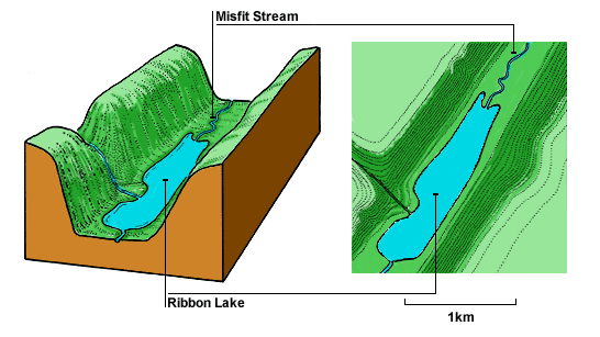
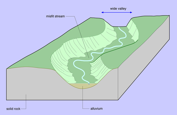
A “misfit river” is a river that is either too large or too small to have eroded the valley in which it flows. This term is also used for a stream or river with meanders that obviously are not proportional in size to the meanders of the valley or meander scars cut into its valley walls. If the misfit stream is too large for either its valley or meanders, it is known as an overfit stream. If the misfit stream is too small for either its valley or meanders, it is known as an underfit stream. A “ribbon lake” is a long and narrow, finger-shaped lake, usually found in a glacial trough. (Source: Wikipedia)
This Earthcache
From this location, you will have a great vantage point of our local misfit river (the “Battle River”) and the upstream end of our local ribbon lake (“Driedmeat Lake”).
The following summary of how the Battle River valley was formed is taken from the website of the Battle River Watershed Alliance: “One of the most interesting features of the present-day Battle River is that the river appears to be much too small and 'under-powered' to have created the deep and wide valley that contains it. In fact, the Battle River is referred to as a 'misfit river' in that it presently occupies a valley that was eroded by volumes of water much greater than present. This rapid, catastrophic erosion occurred more than 10,000 years ago when the last continental glacier began to melt in the central plains of Alberta, forming a series of large ice-dammed lakes. One of the largest we know of was Glacial Lake Edmonton.
As Lake Edmonton filled with glacial meltwaters from the west and north, it eventually spilled over its southern margins. As it did so, the escaping waters eroded a deep, narrow spillway channel. After the lake drained, a large fast flowing river (known as a post-glacial river) ran through this channel. [CO's note: Evidence of this channel can easily be seen from an airplane or Google Maps, with the channel starting around Nisku / Leduc, and heading southeast past Gwynne and east toward the Saskatchewan border.] The Battle's large river valley and “skinny” [or ribbon] lakes southeast of Edmonton - Coal Lake and Driedmeat Lake - are evidence of this old glacial spillway.”
From this location, you will be able to see the Battle River meandering toward you from the west. Approximately 20 km to the east and well beyond your view, the Battle River gains its "misfit" status as it drops down into the widened glacial spillway at a location just south and east of the Gwynne.
As the water in the Battle continues past you to the southeast, it slows down and spreads out into a shallow ribbon lake known as Driedmeat Lake, which is essentially just a slow-moving section of the Battle River. While the lake has been there in one form or another since before Europeans first settled the area, the Province has constructed a number of weir structures at the downstream end of Driedmeat Lake to help regulate the level in the lake as well as to better manage the flows in the Battle River further downstream. The most recent upgrade was completed by the Province in 2010. This upgrade increased the normal water level in the lake by 2 feet (60 centimetres).
Depending on what time of year you visit this site and how recently the contributing area has seen a significant snow melt or a number of significant rainfall events, the level of the lake could be near the “old” normal water level (as you can see if you are looking on Google Maps), or it could be much higher, flooding the low lying lands that are even on the west side of the bridge that sits approximately half way between you and the lake.
The following is an excellent non-scientific commentary on the Battle River, as written by Roger Epp (the former academic dean of the Augustana Campus of the University of Alberta, which is located just north of this location in the City of Camrose). From his compilation of essays, “We Are All Treaty People” (ISBN 978-0-88864-506-7), Epp writes:
“Western Canada is carved by rivers whose headwaters begin in mountain glaciers, whose reputations have been made by the furs borne on them, the cities built beside them or the distant ports reachable by them. The Battle River can claim none of this. It flows from a small lake in the west-central Alberta parkland and eventually into an oversized valley, hollowed in a geological instant, whose broad floor it can only occupy respectfully by means of looping oxbows. The river relies on whatever rain trickles down a thousand creeks to sustain itself after spring run-off. It figures in no great exploration narratives. While the explorer Anthony Henday in 1754 is thought to have been the first European to set eyes on the river and to travel west along its valley, he did so by foot. Having professed in his journals that ‘I cannot describe … the pleasant country I am now in,’ he gave such little account of its features that his turn-of-the-century editor judged his route to have been far to the south.”
Speaking of how slowly the Battle River flows, Epp notes that “the Battle runs through few towns before it joins the North Saskatchewan some 400 twisting miles from its source, surely the slowest feeder river in the great basin that drains into Hudson’s Bay. Any canoeist know as much, having struggled even once with its serpentine form, its beaver dams, and its shallows, against what turn out to be wildly optimistic projections of arrival time.”
Logging Requirements
To log this earthcache, e-mail answers to the following questions to the cache owner to authenticate your online log. Do not post the answers online.
#1) Which category of misfit river ("overfit" or "underfit") would you classify the Battle River? What characteristics do you see that would make you classify it as you did?
#2) Approximately how much wider is the main valley as compared to the misfit river that runs through it? That is, if you were able to straighten out all of the meanders of the Battle River, approximately how many times could you fit the straightened river (side by side) between the north and the south banks of the valley?
#3) Try to describe how high the water level is in Driedmeat Lake at the time of your visit (probably easier if you don't visit in the winter). This will probably be easiest if you describe how where the high water level is with respect to the blue bridge that is located southeast of your location. Has the flooded area reached the bridge? Has it flooded even further to the west (i.e. toward your location)? Even if you visit the site in the winter, you should be able to provide some description of how far back the water level was from the main body of the lake before it froze.
#4) If you are visiting in the winter, #3 will probably be pretty hard to answer. So instead, please answer the following question: Approximately 650m east of the posted coordinates along the gravel road, you will see the road do something that is a bit different from the sections of road around you. Describe what the road does at that location.
#5) (Optional) Feel free to post a photo of either the misfit river (to the west) or the ribbon lake (to the southeast).
Websites for additional information
www.battleriverwatershed.ca
www.en.wikipedia.org/wiki/Misfit_stream
www.en.wikipedia.org/wiki/Ribbon_lake