This Letter Box hybrid cache follows the trail that curves around the old Cabin Branch Pyrite Mine.
A summary of the history surrounding the mine can be found at;
http://www.nps.gov/prwi/historyculture/cabin-branch-mine.htm
An excellent overview of the site was also prepared by the National Park Service and can be found at;
http://www.nps.gov/prwi/planyourvisit/upload/Pyrite%20Mine%202008.pdf
Along the path there will be informational signs which cover some of the historical highlights.
The Detrick and Bradley families formed the Cabin Branch Mining Company in 1889. Oral history relates that John Detrick first discovered the mineral during a hike along Quantico Creek (a tributary of the Potomac River). Near the confluence of the North and South Forks, he noticed something shiny in the water. It was pyrite, known commonly as “fool’s gold”. Detrick made a 200 foot deep shaft in the ground and his efforts were rewarded with the find of a huge body of the ore.
Large by Virginia standards, the mine had 200 to 300 men working above and below ground at any given time, excavating pyrite for use in the production of sulfuric acid. The deepest shaft was reported to be 2400 feet deep with levels every 110 feet. Over 70 buildings supported the mine as well as a narrow gauge railroad that connected the mine to the wharves on the Potomac River.
The Cabin Branch Pyrite Mine was the only pyrite mine in Prince William County and the greatest boost to the local economy in over 100 years. By 1917, Virginia produced more pyrite than any other state in the union, making up 37% of all US production.
Finally abandoned in the 1920’s, Cabin Branch Mine and the land surrounding it was obtained by the Civilian Conservation Corp in 1933, and is now part of Prince William Forest Park. The park encompasses 18,633 acres covering a major portion of the Quantico Creek watershed, and contains one of the few remaining piedmont forest ecosystems in the National Park System.
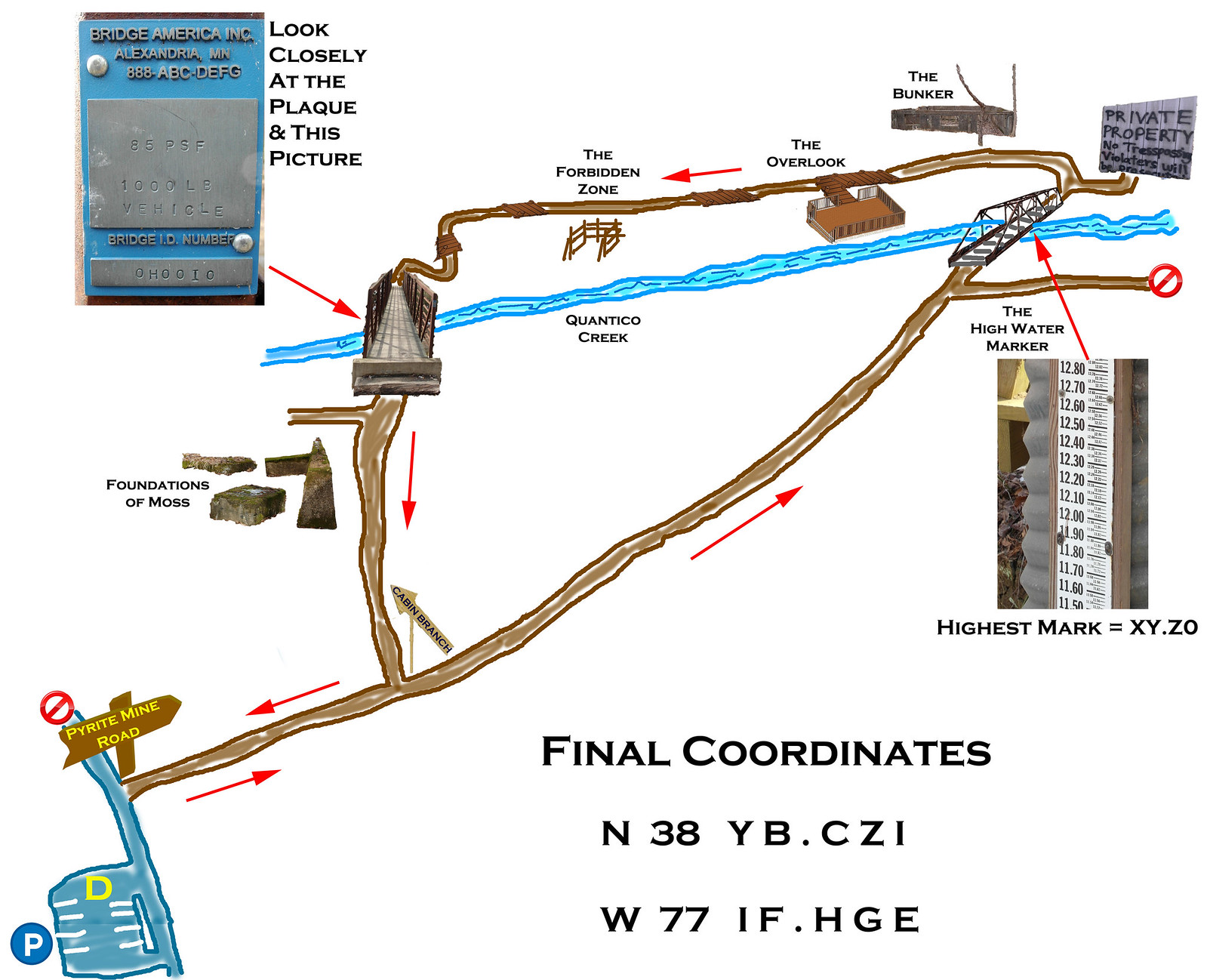
A true Letterbox does not give exact coordinates. It provides a starting point and the information needed to find the final location. Below is a map which if followed will provide clues needed to find the final cache container. Pay attention to the details provided on the map and note landmarks as they are passed. The brown filled in lines represent the trail system coming in and out of the park. Note that this is not a quick park and grab, round trip hike will be approximately 3 miles. Good luck and enjoy the adventure in the spirit intended.

To locate the cache follow the trail in the direction indicated on the map by the red arrows. Two bridges will be crossed along the way. Near the first, look for the High Water Mark. A picture is provided to help locate it. Very large numbers in the form of XX.XX run up the scale. Find the very top value. That value is XY.Z0. NOTE: Water gauge is missing. See info in hint on how to obtain XYZ.
Look at the picture provided on the map for a marker near the second bridge. There you will find the letters A through I. Find the numbers these letters correspond to.
Once you have number values for A-I and X-Z the map will contain the key for their use. The coordinates uncovered will not take you right to the cache. They will put you very near. Once in the area Geosense should start kicking in. Look in the logical place for a large sized ammo can.
Remember to take the time to look at historical markers along the way. The stamp below awaits.
You can check your answers for this puzzle on GeoChecker.com.


Thanks to the NPS for the special permission to NoVAGO to place this cache. Permit available to view on request
Warnings
* Ticks and chiggers are prevalent in the park. Appropriate precautions should be taken.
* Open wells have been found in the park. Known sites have been covered. It is possible others exist. Please use caution and pay close attention to footing and surroundings. (tree roots, etc. on and off trail pose tripping hazards).
* Thermal stresses may be a factor. Permittee should ensure that participants are dressed appropriately and stay hydrated
* Hunting of geocaches is done at searcher's risk as per geocaching.com guidelines
Prince William Forest Park Entrance Fees as of January 2020:
| $20.00 |
per vehicle, 7 consecutive days |
Valid for 7 consecutive days. |
| $15.00 |
per motorcycle, 7 consecutive days |
Valid for 7 consecutive days. |
| $10.00 |
Individual (walking, cycling) |
Valid for 7 consecutive days. |
| $35.00 |
Annual Pass, provides entry for pass holder and occupants of a single personal vehicle (capacity of 14 passengers or less). |
Valid for current year. |