Blauer See - Dolomitgestein
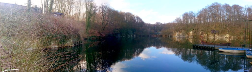
Wer zum ersten Mal den "Blauen See" erblickt, erkennt wahrscheinlich sofort einen Unterschied zu vielen anderen Seen in der Umgebung.
Statt eines langsam abfallenden Ufers finden sich hier zum Teil recht spektakuläre steile Felsen, die den See begrenzen. Dies ist dadurch zu erklären, dass es sich um einen stillgelegten Kalksteinbruch handelt, der mit Grundwasser vollgelaufen ist. Dies erklärt auch die ungewöhnliche Tiefe des Sees.
An den Steilufern lässt sich sehr gut die geologische Entwicklung und Besonderheit dieses Gebietes erkennen, um die es bei diesem Cache geht.
Geologische Entwicklung:
Vor 260 Millionen Jahren lagerte sich vom Grunde des Meeres in den alten Teilen der Steinkohlenzeit Kalk ab. Seine oberen Schichten wurden in Dolomit umgewandelt.
Vor 230 Millionen Jahren dann falteten sich die Kalk- und Dolomit-Schichten mit dem variskischen Alpengebirge, das aber bald wieder abgetragen wurde, steil empor. Danach enstanden Verwerfungsspalten im Dolomitgestein, die hier eine geologische Besonderheit bilden:
Wasser stieg durch diese Spalten nach oben und trug dabei Mineralien wie Quarz, Galenit und Sphalerit mit sich, die in den Spalten auskristallisierten als das Wasser zurückging.
Nachdem das Dolomitgestein dann vor ca. 600 000 Jahren durch eiszeitliche Gletscher abgeschliffen wurde, gelangten diese Kristallisationen an die Oberfläche.
Wie dieser Prozess erdgeschichtlich abgelaufen ist und was genau hier zu finden ist, erfährst du auf der Infotafel an den Listing-Koordinaten. Suche dort die Antworten auf die folgenden Fragen:
1. Vor wie viel Millionen Jahren entstanden die Verwerfungsspalten im Gestein?
2. Wie werden diese Spalten genannt?
3. Die oben genannten drei Mineralien sind auf der Tafel zum Teil anders benannt. Wie heißen sie dort?
Gehe nun links um den See herum (siehe Wegpunkt "Start Rundweg") zur zweiten Station, um die Felsformationen auch aus der Nähe zu betrachten. Auch auf dem Weg dorthin kommmst du an einigen Dolomitgestein-Formationen vorbei.
An der zweiten Station angekommen betrachte die steilen Felsformationen, die den See an beiden Uferseiten begrenzen und beantworte folgende Frage dazu:
4. Wenn die Sonne richtig steht (aber auch sonst bei genauer Betrachtung) siehst du, dass die Felsen viele glitzernde Stellen haben. Um was handelt es sich dabei entsprechend dem, was du an Station 1 gelernt hast? Achte dabei auch auf weitere Felsen in der Nähe der Station, wenn du nicht genug erkennen kannst um die Frage zu beantworten.
Gerne kannst du hier auch ein Foto von dir und/oder dem See machen und mit deinem Log hochladen (optional).
Schicke die Antworten auf die vier Fragen bitte über das Geocaching.com-Kontaktformular.
Du brauchst danach nicht auf eine Logfreigabe zu warten. Sollte etwas nicht korrekt sein, melde ich mich zur Klärung bei dir. Bitte aktiviere daher die Sichtbarkeit deiner Mail-Adresse im Kontaktformular.
Logs ohne entsprechende Mail werden ohne Rückfrage gelöscht.
Du kannst nun entweder denselben Weg zurück gehen, oder den See komplett umrunden, indem du dem Weg weiter folgt und etwas später nach rechts den Berg hoch in einen Waldweg abbiegst. Bitte beachte, dass der weitere Rundweg durchaus eine höhere T-Wertung hat und nicht für Kinderwagen geeignet ist.
Rund um den See finden sich darüber hinaus Spielplätze, Bootsverleih (saisonal), ein Hochseilgarten und einen Märchenzoo, so dass man hier auch noch mehr Zeit verbringen kann wenn man mag.
Quellen und weitere Informationen:
Blue Lake - Dolomite
If you visit the "Blue Lake " for the first time, you will probably immediately recognize a difference to many other lakes in this area.
Instead of a slowly sloping shore you will find quite spectacular steep cliffs here that bound the lake. This can be explained by the fact that it is a disused limestone quarry, which is filled up with groundwater. This also explains the unusual depth of the lake.
The geological evolution and distinctiveness of the area is the reason for placing this cache here.
Geological evolution:
260 million years ago limestone was deposited from the bottom of the sea in the old parts of the Carboniferous. Its upper layers have been converted into dolomite.
230 million years ago then the limestone and dolomite layers folded up steeply with the Hercynian Alps, that vanished again soon after. After that faults and gaps originated in the dolomite rock that here promote a special geological feature:
Water ascended through these gaps and carried minerals like Quartz, Galenite and Spalerite with it, which crystallized in the gaps as the water yielded back.
After the rock has been abraded by glaciers in the last ice age about 600 000 years ago, these criystalisations reached the surface.
From the information board at the listing coordinates you can learn how this geological process worked and what is to be found here. As the board is in German language only, I added some help for each question. Look for the answers to the following questions :
1. How many millions of years ago did the faults in the rock originate (mentioned in paragraph 3)?
2. How are these gaps called (last word of paragraph 3)?
3. Some of the minerals listed above have a different naming on the information board. What names are used here?
Now continue left around the lake (see trailhead waypoint) towards the second stage to have a closer look at the rock formations. On your way to the stage you will also see some dolomite rock formations next to the path.
Arriving at the second stage consider the steep rocks which bound the lake on both sides and answer the following questions:
4. When the sun is at the right spot (or otherwise upon close inspection) you see that these rocks have many glittering spots. What is this, based on what you learned at stage 1? You can also have a look at other stone formations nearby the stage, if you cannot clearly answer the question.
Pictures of yourself and/or the lake from this point are welcome to be uploaded with your log (optional).
Please send the answers to the four questions via the Geocaching.com - contact form.
You do not need to wait for a log permission afterwards. In case of problems I will contact you. Therefore please enable the visibility of your e-mail address in the contact form.
Logs without corresponding mail will be deleted without further notice.
You can now either go back the same way, or continue around the lake by following the path and a little later turn right into a path which continues uphill into the woods. Please note that this part of the trail does have a higher T-rating and thus is not suitable for pushchairs.
Around the lake you can find playgrounds, boat rentals (seasonal), a high ropes course and a small zoo , so you can spend more time here if you like .
Sources and additional information:
Info für Rollstuhlfahrer / Handicaped info: