Purpose of visit: To observe a complex translatory slide site caused as the result of a large-magnitude earthquake and apply earth science to understand how and why the ground movement occurred. As part of the visit you will learn to recognize landforms left behind by translatory slides.
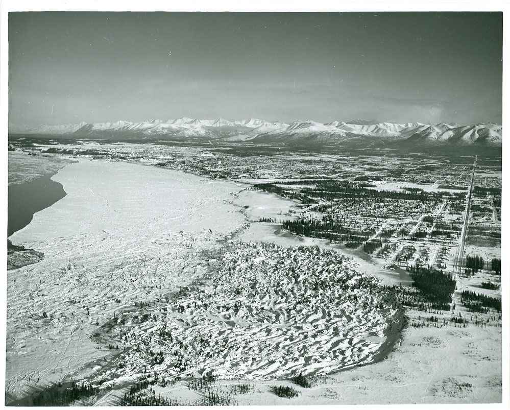
Looking NNE over the 1964 Turnagain Heights Slide, several years after event
This EarthCache takes you on a tour through the westernmost side of the over 8,000 foot long Turnagain Heights slide zone (now known as Earthquake Park). Walk from the parking lot (main waypoint) to the overlook and its interpretive signs (waypoint OP). After viewing the interpretive exhibit, return to the main section of the Tony Knowles Coastal Trail for a stroll down through the slide zone itself to the benches above tidewater (waypoint BW). Along the way, observe and/or measure what you see to learn the answer to these questions:
- How many homes were destroyed in the Turnagain Heights Subdivision?
- How many feet back from the bluff’s edge broke free and slid towards water?
- The overlook is about 70 feet above mean high tide.
A) What is the altitude at the 90 degree bend of the trail (MP) leading down to water’s edge?
B) What is the difference in elevation between the overlook and the benches overlooking the water? (waypoint BW)
- Look at the taller landforms on either side of the trail as you walk downhill.
A) Are they parallel to or perpendicular to the bluff line and the water’s edge?
B) Estimate the average height of these landforms.
C) What are these landforms called (as part of a translational slide)?
- What particular section of what unstable soil type ‘failed’ during the earthquake? Be specific as to which level (example: upper / middle / lower), and the soil name.
- Why doesn’t the bluff just break free and slide towards the water today, either here or further west along the high bluff leading to Pt. Woronzof?
Answers to these questions must be sent to the cache owner by email to validate your ‘found it’ log. Although not required, photographs from the slide zone area are strongly encouraged in your logs to capture a vision of this landscape across the seasons. In particular, the view of downtown Anchorage across Cook Inlet from the area of the benches at waypoint BW is one of the best available. This earthcache is simpler to visualize in the winter months, when the lack of leaves on deciduous trees makes viewing the landforms easier.
Tsunamis were responsible for 119 of the 130 deaths from the 1964 Alaska earthquake, with only 11 deaths caused by building collapse or other seismic-related issues. Despite the incredible destruction in this subdivision, only four persons died here at Turnagain Heights. Sadly, two boys’ bodies were never recovered from the earth fissures which swallowed them up on the eastern side of the slide zone. Most of the wood frame homes here rode out the ground movement aspect of the quake relatively intact, only to be damaged as they were carried as much as 500 feet out onto the mudflats in front of the bluff. The following information will help you learn about the mechanics of this slide event as a result of the earthquake.
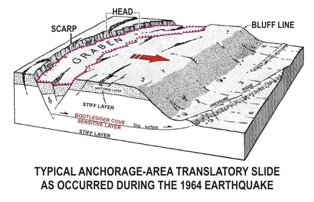
Within the city of Anchorage the quake’s costliest impact was caused by landslides. Triggering of landslides by the earthquake was related to the soil mechanics of the Bootlegger Cove Formation (named after the downtown coastal subdivision where it was first identified), a glacial estuarine-marine deposit that underlies much of the Anchorage area at soil depths just above sea level. These soils were laid down by rivers draining glacial valleys just prior to the ‘Naptowne’ glaciation period (10,000–12,000 years ago). Naptowne-era gravels were laid down over most of Anchorage in the last glaciation event this area experienced. In general the Bootlegger Cove Formation consists of three physically distinct but gradational zones - an upper and a lower stiff competent zone and a central weak sensitive zone. Failures under the vibratory stress of the earthquake occurred chiefly in the central zone of Bootlegger Cove Formation soils, where low shear strength, high water content, and high sensitivity to stress are evident. The major destructive landslides in the Anchorage area moved primarily by translation (soil transferring relatively intact from one location to another on a mild grade), moving on nearly horizontal slip surfaces after loss of strength in the weakest layer of the Bootlegger Cove Formation. These slides occurred at locations involving flat-topped bluffs bounded by steep slopes facing lower ground. Destructive translatory slides of unique variations in size, appearance, and complexity occurred in the downtown area (Fourth Avenue slide), at Government Hill (the elementary school slide), and at Turnagain Heights (now Earthquake Park). The effects and aftermath of the landslides are still clearly evident at these sites fifty years later.
The earthquake began with distinct east-west ground movement. The earth moved in waves on this east-west axis, which caused the homes in the Turnagain Heights subdivision to pitch objects on shelves or in cabinets on east or west walls out onto the floor of the house. Ground movement was so strong trees literally slapped the ground to their east and west sides, and persons often were unable to stand upright. At some point between 1 ½ to 2 minutes into the earthquake, ground motion shifted from an east-west axis to a north-south axis. This had a distinct effect on soils underlying the Turnagain Heights subdivision in the middle (weakest) layer of the Bootlegger Cove soil formation, about 15 to 20 feet above mean sea level. The weakest soils had reached their ‘failure’ point, where they liquefied and lost their cohesion, due to the incredible strength of the strong east-west shaking, and the length of the shaking. They were now very prone to sliding across the stronger soil layer beneath because the huge amount of energy had liquefied the weakest soil layer. This failure in a soil plane which tilted at a gentle seven-degree slope towards the beach meant it was ripe for movement as the ground waves changed direction. The earthquake-generated energy of ground waves moving in a south to north direction added a gravitational “push” to the land mass. Midway through the earthquake, much of the Turnagain Heights subdivision began to glide slowly out into Cook Inlet. Further, the tide flats were wet and ‘greasy’ with no braking of motion to be found in terms of frozen or elevated soils in front of the slide. As the horsts formed by the slide began to move along towards the water, there was hardly anything stopping their gentle glide. The landslide disgorged itself out onto the mudflats, eventually to cover an area twice its original size.
Average displacement of homes in the area exceeded 500 feet laterally towards the water and 35 feet lower in elevation. Despite the incredible spread of the landslide, none of the horsts rotated during the slide in part due the gentle slope and lack of resistance as they glided forward away from the scarp. Homes collapsed willy-nilly across the patchwork pattern of horsts and grabens.
During the city’s early years, little thought was given to how an earthquake would impact construction across the city. Despite evidence of prior landslides, buildings went up all across zones in downtown Anchorage, on Government Hill, and in the Turnagain Heights subdivision with little to no understanding of what would happen to the underlying soils when subjected to the intense energy of a high-magnitude earthquake. The evidence of prior massive earthquakes was present, yet no one studied the soils and the obvious evidence present in the city’s topography to make the connection about how the earth would react to large-magnitude earthquakes. It was left to the events of March 27, 1964 to bring on an emphasis in the study of the city’s underlying soils, and their ability (or lack thereof) to ride out big earthquakes. The 1964 earthquake also helped to bring the concept of plate tectonics to the forefront of our understanding about why these types of earthquakes occur in specific zones and ‘arcs’ across the planet.
Terms to understand:
Liquefaction describes a soil’s failure to remain cohesive and strong during a period of stress while it contains a large volume of water. Under too much stress the soil cohesion fails and it behaves like a fluid.
Graben is the name for the sunken section of land created behind the soil blocks moving along in the slide. Several graben (or more) can be formed in a slide zone, and they are generally perpendicular in alignment to the direction of movement of the soils.
Horst is the name used for large blocks of soil which have remained intact and upright in between graben features, perpendicular to the direction of soil movement. They’re more common in simple slides, and less common in more complex slide sites. At Turnagain Heights subdivision the slide site has a large quantity of smaller horsts scattered across the slide zone, perpendicular to the direction of soil movement out to the mud flats.
Head of slide Scarp is a term describing the uppermost point of the area of slide movement (the head). The crown is the area which is visible after the slide as being at the top of a Scarp (soil embankment or sheer bluff). Here, the overlook is atop and just behind the westernmost point of the crown of the Turnagain Heights slide scarp.
Undercutting is the term used to describe the removal of soils or structure at the toe of a bluff. This action can significantly reduce soil resistance to slide triggers, making landslides more likely. This was a significant factor at the Government Hill slide zone.
The diagram below illustrates a simplified view of the soil structure found at the three slide sites, with Naptowne soils deposited over Bootlegger Cove Formation soils. The upper and lower layers of the Bootlegger Cove Formation are stiff and competent soils under most conditions, but the middle layer tends to be weaker and less cohesive under extreme stress and shaking. This is the soil layer which experienced liquefaction of its elements, allowing blocks of soil above it to slide away to lower ground. Note the graben formed by subsiding wedges of soil which sink down in height as blocks of soil below them move away from the head of the slide. The weight of the graben behind the sliding block adds more pressure for movement once the weak layer of soil has failed, adding impetus to the movement away from the head of the slide. As the blocks of soil move, more graben may form as the blocks crack and separate into smaller blocks. When the foot of the bluff is excavated or removed (undercutting), support for the block of soil behind the bluff line is decreased, which increases the likelihood of a translatory slide.
Resources used to develop this EarthCache:
Effects of the Earthquake Of March 27, 1964 at Anchorage, Alaska
By Wallace R. Hansen
U.S. Geological Survey Professional Paper 542-A
A Guide To The Geology Of Anchorage:
A Commentary On The Geotechnical And Historical Aspects Of Selected Localities In The City
By R.G. Updike, C.A. Ulery, and J.L. Weir
Alaska Division of Geological and Geophysical Surveys, June 1986
Pictures (unless otherwise noted) are in the public domain, from the archives of the U.S. Geological Survey.