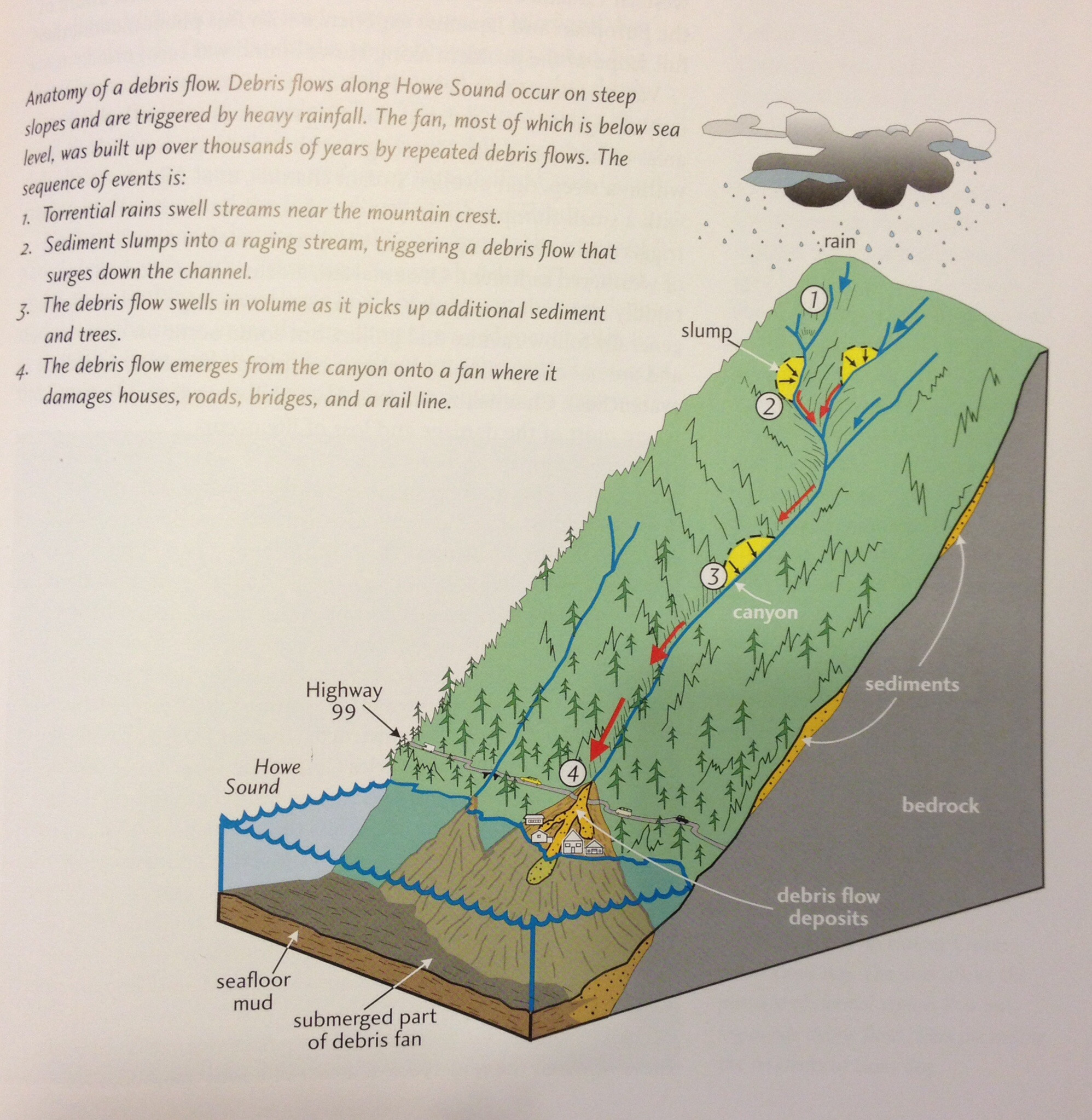
After the glaciers receded 10,000 years ago, leaving behind the rugged beauty of the Coast Mountains, they also left very unstable surfaces. The glacial till left behind was composed of large and small rocks with a lot of looser gravel type rocks. The till also left formations known as kame terraces which all eventually collapsed as the meltwater flowed downhill.
For thousands of years, avalanches of rocks and tree debris were a regular occurrence on the unstable slopes all along Howe Sound. Sometimes the avalanches were caused by small earthquakes shaking loose the rocks and trees that were easily uprooted. Most often, however, the avalanches were caused by rainfall accumulating behind larger rocks and fallen trees. An avalanche that consists of a variety of mud, tree debris and rocks is known as a debris flow. (You may have heard them called other equivalent names such as debris torrents, avalanches, mud flows, rock falls, landslides).
Human modification of the terrain all along Howe Sound has triggered hundreds of landslides. The many channels of water flowing downhill along the mountains in Howe Sound add to the severity of the landslides as the water channels can lubricate the path of the falling debris, and in many cases, form makeshift dams which easily burst as torrential rains swell the slumps along the mountainside. As the debris flow reaches the water below, it accumulates and forms a debris fan.

The community of Lions Bay, which was founded in the 1960s on the site of a debris fan, is no stranger to the hazards of debris flow. In 1983, the nearby Alberta Creek experienced one of the most devastating debris flows in recent history. In February that year, with melting snow and torrential rain pushing down accumulated boulders, fallen trees and sediment, the channel of the creek overflowed bringing down an estimated volume of 5000 – 10,000 cubic metres of debris onto the town below. As the debris avalanche flowed, it picked up more and more debris and speed. Homes, culverts and bridges were destroyed and sadly two boys were killed.
This Earthcache takes you to one example of a series of dams that were engineered as solutions to the ongoing problem of damaging debris flows all along Howe Sound. Fortunately since they were built, at a tremendous cost to the Province, there have been no further serious debris flows along the Sea to Sky region of Howe Sound.
To log this Earthcache, stand at the coordinates and make the following observations. To claim a find, you must email (do not use the message centre as I don't read those) to the cache owner the answers to the following questions. Please note that found logs without an accompanying email answering the questions must be deleted as per the Earthcache guidelines.
1. Behind this dam is a large pool. This dam has two large holes cut at the base. Why do you think that is? Do you see any debris flowing in the creek?
2. Describe the creek bed as it flows downhill (eg, size and composition of the rocks in the bed). What has been done to the creek bed?
3. What is the elevation at the point you are standing? Can you estimate the height of the dam relative to your position?
References:
"Vancouver, City on the Edge" by John Clague & Bob Turner ISBN 0-9697601-4-0
“Sea to Sky Geotour” http://publications.gc.ca/collections/collection_2010/nrcan/M4-83-7-2010-eng.pdf
http://www.keeplionsbayunique.com/AboutMudslides.html