Dragonfly Marsh Earthcache EarthCache
This cache has been locked, but it is available for viewing.
Dragonfly Marsh Earthcache
A cache by [DELETED_USER]
Hidden
:
4/20/2015
-
Difficulty:
-

-
Terrain:
-
Size:  (other)
Please note Use of geocaching.com services is subject to the terms and conditions
in our disclaimer.
Dragonfly Marsh is a tiny sliver of the Columbia Valley River Wetlands that cover approximately 27,430 hectares and stretching from Canal Flats in the south for 180 kilometers to Donald Station in the north. These wetlands are the largest continuous wetlands in North America. Over 64% of the worlds wetlands have disappeared since the 1900’s.

Two major geological factors contributed to the creation of this massive wetland area.
First the wetlands are within the Rocky Mountain Trench that runs North South for approximately 1,600 K and is from 760 m to 960 m above sea level. The Trench and therefore the wetlands are sandwiched between the Purcell/Selkirk mountains in the west and the Rocky Mountains to the east and is relatively flat the entire length. A complex fault zone between these mountain ranges is attributed to the creation of this trench.
Glacial Lake Invermere is the second major contributing factor. This lake was created after the last glacial period 10,000 years ago. As the glacier retreated north up the Rocky Mountain Trench and as a result of a sediment dam and bedrock outcrops in the south (just north of Skookumchuk) and the blocking Beaver Valley & Trench glaciers in the north, a lake of 210K in length was created. This lake averaged 2.5 k in width and 100 m deep. Sedimentary deposits are very extensive between Canal Flats and Brisco that average 50 m. Columbia Lake and Lake Windermere are largest remaining bodies of water.
The wetlands are also part of the Columbia River system that originates near Canal Flats and terminates 2,000 K into the Pacific Ocean at Astoria Oregon. The Columbia River derives its name from Capt. Robert Gray who named the river after his sailing ship the Columbia Rediviva. More than 80 mountain streams feed the wetlands over its length.
Wetlands are like giant sponges that absorb and replenish the water and are distinct ecosystems. Some of the system is within Provincial Park boundaries and also managed by the Nature Trust. These wetlands are comprised of open water (30%) and marshes (35%). This ecosystem is home to over 17 species of fish, 265 bird species, 50 mammals and is a vital component of the Pacific Flyway for migratory birds. For the migratory birds and resident birds it is almost the last resting and breeding habitat. Dragonflies and fireflies can be seen is various locations such as this spot and around Fairmont and Canal Flats. There are almost 26 varieties of dragonflies found here.
The gradient is about 20 cm per kilometer, which allows for the slow movement of the Columbia River through the wetland area resulting in numerous, marshes, channels, islands, sloughs while it meanders northward. The marshes and ponds formed around the bends in the river created the almost contiguous wetland. This gradient drop is equivalent to a drop of only 65 meters in 180 K.
Marshes are wetlands that periodically are flooded by standing or slowly moving water. They contain peculiar aquatic vegetation such as, reeds, rushes and noted for the absence of wooded vegetation. the soil is referred to as being hydric, that is permanently saturated with water that is from a water table close to the surface.
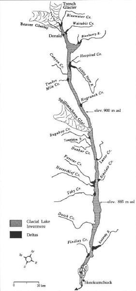
Paleogeographic reconstruction of glacial Lake Invermere, at its maximum extent.
Acknowledgements: BC Provincial Parks publications, Ducks Unlimited, Nature Trust of BC, O. Sawicki & D. Smith of University of Calgary
In order to log this Earthcache, please email the author of the cache with the answers to the following questions:
1) How is this marsh filled with water, where does the water come from?
2) How do you grade the health of this marsh based on the existing geology?
3) Not all of the marsh is seasonally dry and a large pond is home to wintering waterfowl. Why does this pond usually not freeze over? Due to source of the water?
Additional Hints
(No hints available.)