This particular escarpment is referred to as the Knobstone Escarpment. It stretches over 100 miles from New Albany north to Martinsville. The most prominent topographic landform is a rocky ridge in southeastern Indiana called the Knobstone Escarpment. This ridge, towering hundreds of feet above the Scottsburg Lowland to the east, extends from southern Johnson County southward across the Ohio River into Kentucky. These hills mark the easternmost extension of rocks forming the rugged country of the Norman Upland to the west. The Knobstone Escarpment is composed of resistant siltstones of the upper part of Borden Group rocks. Older and more easily eroded shales to the east form the Scottsburg Lowland; a thick section of soluble limestones form the low, undulating Mitchell Plain west of the Norman Upland.
Immediately west of the Scottsburg lowland, this bold escarpment towers over the lowland by hundreds of feet. It is called the Knobstone Escarpment from the old formation name given to the rock in which it is formed. Prominences in the crest of this reaches an altitude of over 1,000 feet. It is known as the greatest relief feature and the most prominent topographic form in the state. There are lots of steep slopes, but it is rarely unscalable. Near the lowlands it appears wall-like and unbroken, but farther north it is more broken by streams and forms knobs.
An escarpment is a steep slope or long cliff that occurs from faulting and resulting erosion and separates two relatively level areas of differing elevations. Usually escarpment is used interchangeably with scarp (from the Italian scarpa, shoe). But some sources differentiate the two terms, where escarpment refers to the margin between two landforms, while scarp is synonymous with a cliff or steep slope. The surface of the steep slope is called a scarp face.
Scarps are generally formed by one of two processes: either by differential erosion of sedimentary rocks, or by vertical movement of the Earth's crust along a geologic fault. Most commonly, an escarpment is a transition from one series of sedimentary rocks to another series of a different age and composition.
Escarpments are also frequently formed by faults. When a fault displaces the ground surface so that one side is higher than the other, a fault scarp is created. This can occur in dip-slip faults, or when a strike-slip fault brings a piece of high ground adjacent to an area of lower ground.
More loosely, the term scarp describes the zone between coastal lowlands and continental plateaus which have a marked, abrupt change in elevation caused by coastal erosion at the base of the plateau.
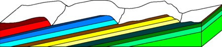
Schematic cross section of a cuesta, dip slopes facing left, and harder rocklayers in darker colors than softer ones.
Earth is not the only planet where escarpments occur. They are believed to occur on other planets when the crust contracts, as a result of cooling. On other Solar System bodies such as Mercury, Mars, and the Moon, the Latin term rupes is used for an escarpment.
When sedimentary beds are tilted and exposed to the surface, erosion and weathering may occur. Escarpments erode gradually and over geological time. The mélange tendencies of escarpments results in varying contacts between a multitude of rock types. These different rock types weather at different speeds, according to Bowen's Reaction Series so different stages of deformation can often be seen in the layers where the escarpments have been exposed to the elements. These varying levels of erosion can lead to strange features forming in the exposed rock.
To log this earthcache, send the answers to my registered account:
- How many layers are seen in this Knobstone Escaprment?
- Are the layers the same size?
- Do the layers have the same geological appearance?
- Do you see any signs of erosion in the rocks?
Post a picture of yourself (face not required) or a personal item at the escarpment.