
Français
Un puits artésien est un puits où l'eau jaillit spontanément. Ce phénomène a été mis en évidence pour la première fois par les moines de l'abbaye de Lillers, en Artois en 1126, d'où son nom.
L'artésianisme se produit lorsque la configuration particulière de la géologie d'un lieu et sa topographie provoquent une telle mise en pression de l'aquifère que la ligne piézométrique « sort » du sol. Un aquifère est une formation géologique ou une roche, suffisamment poreuse et/ou fissurée (qui peut stocker de l'eau) et perméable (où l'eau circule librement).
L'eau, qui pénètre dans le bassin artésien, s'accumule au cours des milliers d'années. Il ya une différence essentielle entre cette eau et des eaux souterraines - c'est couche imperméable au plafond du bassin. Avec cette isolement, l’eau est très bien protégé contre les pollutions de surface. La région la plus célèbre de l'apparition de ce type d'eau est le Grand Bassin Artésien en Australie, tandis que le plus grand est l'aquifère Ogallala dans l’État du Dakota (USA). Aquifères artésiens sont également présents en Europe - par exemple le Bassin Parisien en France, ou le Bassin de Londres au Royaume-Uni. En Pologne, nous avons le Bassin de la Masovie, Bassin de Lodz et le Bassin de la Nida.

Qu'est-ce que « l'Oligocène »?
L’Oligocène est une époque géologique qui suit l’Éocène et précède le Miocène. C’est la troisième époque de l’ère Cénozoïque et aussi la troisième du Paléogène. Son nom se réfère à la rareté d’apparition de nouveaux mammifères modernes en comparaison de leur rapide apparition durant l’Éocène.

Ce graphique est publié avec l'autorisation écrit du président de ICS, Professor Stanley Finney, Dept. Geological Sciences, California State University at Long Beach.
Les eaux souterraines à Varsovie se produisent dans les niveaux quaternaires et tertiaires. Les eaux quaternaires sont largement exposés à la pollution d'origine anthropique, et l'eau miocène de niveau tertiaire est contaminé en raison de la présence de lignite - ce qui explique pourquoi à Varsovie ont été mis en place que quelques puits - dans arrondissement Wola et dans Żoliborz («joli bord ») - pour les brasseries, usines électroniques et pharmaceutiques . En revanche, l'eau tertiaire de niveau de l'Oligocène est beaucoup plus propre que l'eau quaternaire, car elle est protégée contre la pollution par des couches imperméables (argiles pliocènes) et ne nécessitent qu'un simple purification.

L'eau artésienne d'Oligocène a été découvert à Varsovie en 1897, pendant la recherche de l'eau pour l'usine de l'alcool dans rue Ząbkowska. Cette eau de l'excellente qualité a été trouvé à une profondeur de 217 m. L’eau jaillissait alors à une hauteur de 15 mètres au-dessus du sol. Depuis ce temps, des centaines de puits ont été construits et l'eau est tirée, parmi d'autres, à des fins industrielles et alimentaires (les usines consomment environ 88% de la consommation d'eau de l'Oligocène). En raison de sa surexploitation, la pression de l'eau d'origine a considérablement diminué et l'eau artésienne à Varsovie ne coule plus spontanément sur la surface de la terre - à son extraction les pompes électriques sont utilisés.
Avant de commencer l'extraction, la pression de l'eau dans les sédiments de l'Oligocènea été supérieur de 2 atm. que la pression au niveau de la Vistule, tandis que dans les années 80, en raison de la surexploitation, entonnoir de la dépression dépasse pas 50 m sous la surface du sol. Actuellement, à la suite de l'extraction limitée de ces eaux, l'entonnoir de la dépression est en cours de "reconstruire".
Le niveau de l'aquifère oligocène dans la région de Varsovie est associée à des dépôts de sable et de sable-gravier survenant à une profondeur d'environ 200-270 m. La profondeur de puits, où vous êtes maintenant est de 274 m (Oligocène). Pour la comparaison - les puits artésiens à Paris (Albien) sont beaucoup plus profondes - Fontaine du Square Lamartine (GC50N8Y) - 586 m, Puits artésien de la place Hebert (GC536WT) - 718 m.
Il ya une très faible chance de la contamination de l'aquifère de l'Oligocène partir de la surface, grâce à une excellente isolation naturelle. Cet isolement est formé par un ensemble de 100 mètres d'épaisseur des argiles pliocènes. Cela garantit la stabilité de la composition de l'eau et sa bonne qualité. La seule menace peut être ici d'une contamination géogénique. Elle se manifeste, par exemple, par la couleur, associée à l'infiltration de l'eau à partir du niveau du Miocène (présence de lignite). L'eau dans les formations oligocène de l'ouest de Varsovie, se caractérisé par une minéralisation élevée env. 400-1000 mg/dm3 (localement plus de 1000 mg/dm3) et relativement haute teneur en chlorures, dépassant souvent les 200 mg/dm3.
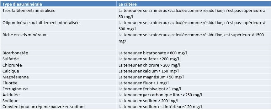
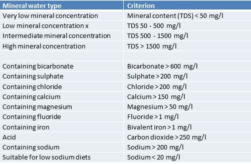
Les critères pour les eaux minérales
Une eau minérale naturelle ne peut être que d'origine souterraine, et s'être constituée à l'abri de tout risque de pollution. Microbiologiquement saine dès l'origine, elle n'est perturbée par aucune contamination d'origine humaine. La principale caractéristique de l'eau minérale naturelle réside dans sa pureté originelle qui est une exigence de la réglementation. Les eaux minérales naturelles ont une composition physico-chimique stable qui peut leur permettre de se voir reconnaître des propriétés favorables à la santé humaine.
En résumé, l'eau minérale naturelle est définie par trois critères majeurs : absence de tout traitement ou d'addition de produits chimiques, sa pureté originelle à la source et donc l'absence de tout polluant d'origine humaine et enfin une composition minérale définie, parfaitement stable et garantie.
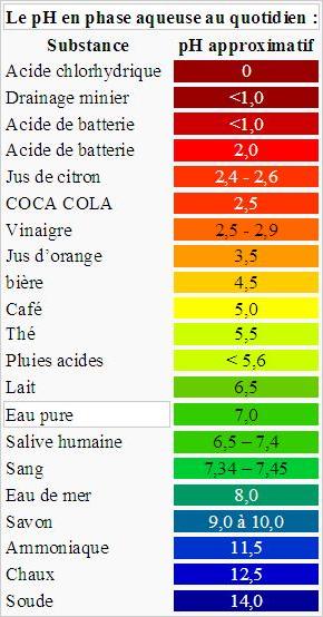
Le potentiel hydrogène
Le potentiel hydrogène (ou pH) mesure l'activité chimique des ions hydrogène (H+). Notamment, en solution aqueuse, ces ions sont présents sous la forme de l'ion oxonium (également, et improprement, appelé ion hydronium).
Plus couramment, le pH mesure l’acidité ou la basicité d’une solution:
- une solution de pH = 7 est dite neutre ;
- une solution de pH < 7 est dite acide; plus son pH s'éloigne de 7 (diminue) et plus elle est acide ;
- une solution de pH > 7 est dite basique; plus son pH s'éloigne de 7 (augmente) et plus elle est basique.
Rappel concernant les « Earthcaches »: Il n'y a pas de conteneur à rechercher ni de logbook à renseigner. Il suffit de se rendre sur les lieux et d'exécuter les requêtes du geocacheur (par exemple l'envoi d'un mail pour validation).
Votre mission:
S'il vous plaît envoyer vos réponses via mon profil de GC. Il n'y a pas besoin d'attendre ma réponse, vous pouvez vous loguer immédiatement. Si la réponse est incorrecte, je vous contacterai. S'il vous plaît rappelez-vous que les logs sans réponses seront supprimés!
Pour loguer un "found it" sur cette cache il sera nécessaire de mettre dans le log une photo de vous à côté du rocher, et de me répondre aux questions suivantes:
- Quel est l'âge de l'aquifère de l'Oligocène?
- Concernant la composition minérale et chimique de l'eau - quelle type d'eau est-il?
- Concernant le pH de l'eau - quelle type de solution est-il (acide / alcalin) et quelles autres substances peut il correspondre?
- Quel est le minimum de pression hydrostatique sur la surface de ce réservoir d'eau souterrain pour permettre jailli de l'eau spontanée du puits?
Équation pour calculer la pression hydrostatique:
p = ρ • g • h
où:
p = la pression (N/m2, Pa)
h = la profondeur dans le fluide au cours de laquelle la pression est mesurée (m)
ρ = la masse volumique du liquide (pour environ d'eau. 1 000 kg/m3)
g = Intensité de la pesanteur (9,81 m/s2)
Outil simple pour convertir des unités de [Pa] à [atm]:
http://metricconversion.biz/fr/conversion-des-unites-de-pression.html
5. D'après vous, est l'eau de l'Oligocène plus saine que l'eau du robinet? Pourquoi?
Remarques:
Pour répondre à Q2-Q3 vous devriez visiter l'emplacement du cache.
N'hésitez pas à ajouter des images ne contenant pas de spoilers!
BON GEOCACHING
Références:
van der Aa N.G.F.M. (2003), Classification of mineral water types and comparison with drinking water standards, “Environmental Geology”, No 44:554–563.
Cohen K.M., Finney S.M., Gibbard P.L., Fan J.-X. (2013), The ICS International Chronostratigraphic Chart, “Episodes”, 36(3): 199-204.
Foster S., Loucks D. P. (2006), Non-renewable groundwater resources: A guidebook on socially-sustainable management for water policy makers, UNESCO.
Frère Ch., Krempf P. (2002), Mécanique des fluids, Ellipses Marketing, Paris.
Nowicki Z. (2008), Wody podziemne – szansa da Warszawy, „Przegląd Geologiczny”, vol. 56, nr 4.
Nowicki Z. (2007), Wody podziemne miast wojewódzkich Polski, „Informator Państwowej Służby Hydrogeologicznej”, Warszawa.
http://www.surowce-naturalne.pl/strona/woda-pod-warszawa
Directive n° 2009/54/CE du 18/06/09 relative à l'exploitation et à la mise dans le commerce des eaux minérales naturelles

English
Artesian wells are created by drilling a hole to deep aquifers (so-called artesian water). The water there is under a high hydrostatic pressure (approx. tens atmospheres), enabling the automatic exit from such a hole. This causes the water level in a well to rise to a point where the hydrostatic equilibrium has been reached. As the result of this hydrostatic pressure, water comes out with a strong stream to a certain level, reminding a fountain. Artesian wells were named after the former province of Artois in France, where many artesian wells were drilled by Carthusian monks from 1126.
The waters inside the artesian aquifer accumulate over thousands of years. They are very different from the groundwater because there is an impermeable layer in the ceiling of the aquifer. Thanks to such isolation they are much less polluted than the surface water. Suitable conditions to produce a hydrostatic pressure occur most frequently in areas with the U-shaped system of rock layers. The most famous region of occurrence of this type of water is the Great Artesian Basin in Australia, while the largest is the Great Basin in Dakota (USA). Artesian aquifers are also present in Europe - for example, in the Paris Basin, or Basin of London. In Poland - we have Mazowiecki Basin, Basin of Lodz and the Nida Basin.

What is the "Oligocene"?
In the geochronological terms, it is the third and final epoch of the Paleogene period, lasting about 11 million years. The Oligocene extends from about 33.9 million to 23 million years before the present (33.9±0.1 to 23.03±0.05 Ma). It is preceded by the Eocene epoch and is followed by the Miocene epoch.
The start of the Oligocene is marked by a notable extinction event called the Grande Coupure; it featured the replacement of European fauna with Asian fauna, except for the endemic rodent and marsupial families. By contrast, the Oligocene–Miocene boundary is not set at an easily identified worldwide event but rather at regional boundaries between the warmer late Oligocene and the relatively cooler Miocene.
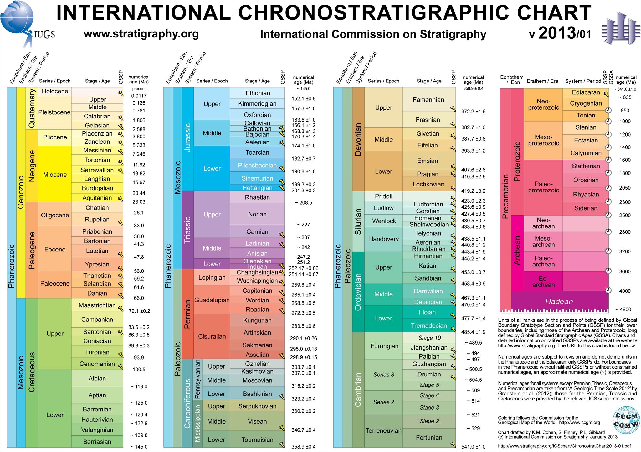
This chart is published with a written consent of the ICS Chair, Professor Stanley Finney, Dept. Geological Sciences, California State University at Long Beach.
In the Warsaw area, groundwater occurs within the Quaternary and Tertiary level. Quaternary water are more exposed to anthropogenic pollution, and the Miocene water from the tertiary level is contaminated because of the occurrence of lignite, which is why in Warsaw only a few Miocene wells was established – in Wola and Zoliborz quarters. They were designed mainly for breweries and electronics or pharmaceutical manufactures. In contrast, tertiary water from Oligocene period is much cleaner than the Quaternary water, as it is protected against pollution by impermeable layers (Pliocene clays) and require only simple treatment.

Oligocene aquifers were discovered in Warsaw in 1897, during the searching for water for the liquor squads at Ząbkowska Street. A reservoir of water of the excellent quality was found at a depth of 217 m. During drilling this well, water flowed at a height of 15 meters above the ground with a flow rate of 160 m3 per hour. Since that time, hundreds of boreholes were made and water has been used for industrial and comestible purposes (production plants consume about 88% of the Oligocene water). As a result of overexploitation, the primary water pressure significantly decreased and Artesian water in Warsaw no longer automatically flows over the surface of the terrain - to its extraction electric pumps must be used.
Before the exploration started, the pressure of water in the Oligocene aquifers in Warsaw was higher by 2 atm. than the water pressure at the level of the Vistula river. In the 80’s, due to over-exploitation, depression pit lowered 50 m below the ground surface. Currently, as a result of limiting the use of these waters, we can observe "rebuilding" this depression pit.
The Oligocene aquifer level in the Warsaw area is associated with sand and sand-gravel deposits occurring at a depth of approximately 200-270 m. The depth of the well, where you are right now, is 274 m (Oligocene). For comparison - the artesian wells in Paris (Albian) are much deeper - Fontaine du square Lamartine (GC50N8Y) - 586 m, artésien Puits de la place Hébert (GC536WT) - 718 m.
There is a low risk of contamination of this water by pollution from surface. A 100-meter-thick package of Pliocene clays creates a very good natural isolation layer. This ensures the stability of the chemical composition of the water and its good quality. The only threat can be here a geogenic contamination. This may be observed, for example, in change of color, which is associated with the infiltration of water from the Miocene level (presence of lignite). Water occurring in the Oligocene formations in the western part of Warsaw, is characterized by elevated mineralization – approx. 400-1000 mg/dm3 (locally> 1000 mg/dm3) and fairly high content of chlorides, often exceeding 200 mg/dm3.
Criteria for mineral waters
Natural mineral water can only be from groundwater, and have to be free from any risk of pollution. They should be also microbiologically safe and not affected by any contamination of human origin. The main feature of the natural mineral water is in its original purity. Natural mineral waters have a stable physico-chemical composition that can enable them to be recognized as favorable to human health properties.
The potential of hydrogen
The pH is a measure of the acidity or basicity of an aqueous solution. Solutions with a pH less than 7 are said to be acidic and solutions with a pH greater than 7 are basic or alkaline. Pure water has a pH very close to 7.
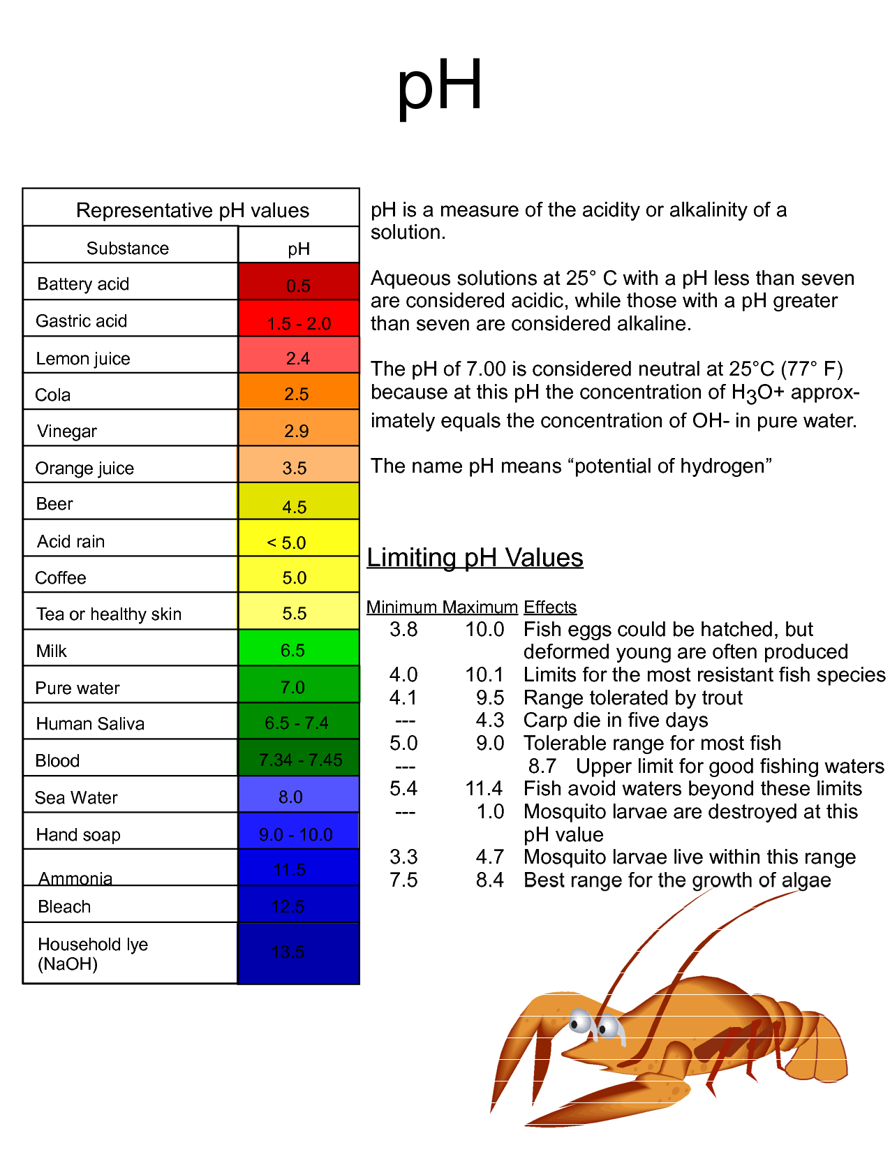
The potential of hydrogen
The pH is a measure of the acidity or basicity of an aqueous solution. Solutions with a pH less than 7 are said to be acidic and solutions with a pH greater than 7 are basic or alkaline. Pure water has a pH very close to 7.
Tasks:
To log this EarthCache you should answer to the following questions:
- What is the age of the Oligocene aquifer?
- Regarding the water composition - what type of water is it?
- Regarding the water pH - what kind of solution is it (acid/alkaline) and to which other substance may it be similar?
- What minimum hydrostatic pressure should be on the surface of this underground water reservoir to enable automatic flow of water from the well? Equation for calculating hydrostatic pressure:
p = ρ • g • h
where
p = pressure (N/m2, Pa)
h = height of fluid column, or depth in the fluid at which the pressure is measured (m)
ρ = density of liquid (for water approx. 1000 kg/m3)
g = the gravitational constant (9.81 m/s2)
Simple tool for converting units of [Pa] to [atm]:
http://metricconversion.biz/fr/conversion-des-unites-de-pression.html
- In your opinion, is the Oligocene water healthier than the tap water? Why?
Note:
To answer Q2-Q3 you should visit the cache location.
Feel free to add pictures not containing spoilers!
Please send your answers using my GC profile. There's no need to wait for my reply, you can log immediately. If the answer is incorrect, I will contact you. Please remember that the logs without answers will be deleted!
BON GEOCACHING
References:
van der Aa N.G.F.M. (2003), Classification of mineral water types and comparison with drinking water standards, “Environmental Geology”, No 44:554–563.
Cohen K.M., Finney S.M., Gibbard P.L., Fan J.-X. (2013), The ICS International Chronostratigraphic Chart, “Episodes”, 36(3): 199-204.
Foster S., Loucks D. P. (2006), Non-renewable groundwater resources: A guidebook on socially-sustainable management for water policy makers, UNESCO.
Frère Ch., Krempf P. (2002), Mécanique des fluids, Ellipses Marketing, Paris.
Nowicki Z. (2008), Wody podziemne – szansa da Warszawy, „Przegląd Geologiczny”, vol. 56, nr 4.
Nowicki Z. (2007), Wody podziemne miast wojewódzkich Polski, „Informator Państwowej Służby Hydrogeologicznej”, Warszawa.
http://www.surowce-naturalne.pl/strona/woda-pod-warszawa
Directive 2009/54/EC of the European Parliament and of the Council of 18 June 2009 on the exploitation and marketing of natural mineral waters.