FRANÇAIS :
Préparez-vous à découvrir une destination authentique et d’une grande diversité. Des plaines à niaoulis des espaces de l’ouest aux cascades noyées de verdure de la côte est et de la chaîne centrale, en passant par les collines arides du Grand Nord, les îlots et les plages désertes, la terre rouge du pays minier, le Nord calédonien a bien des choses à partager avec vous : une nature magnifique, une histoire riche, une biodiversité exceptionnelle, un lagon inscrit par l’Unesco au patrimoine mondial de l’humanité, une population multicolore au caractère bien trempé...
Cache N°8 : GR® Nord Pombeï/Tiwae
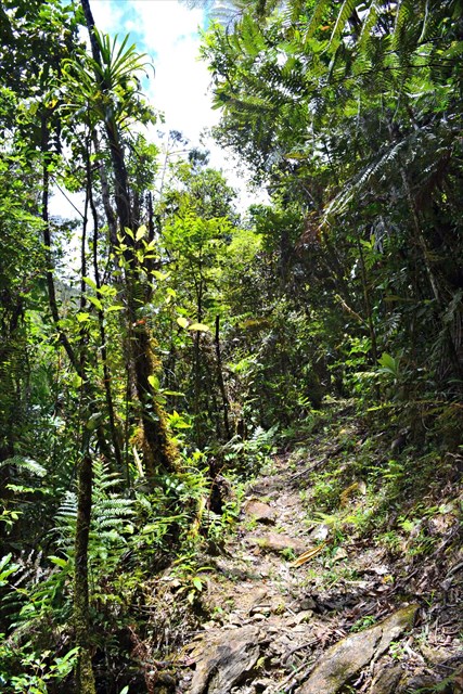
Relier les tribus entre elles par un magnifique sentier de randonnée, balisé aux normes de la Fédération Française de Randonnée comme une ligne verte naturelle franchissant des chemins jusqu’ici peu fréquentés, parcourir la province Nord dans ce qu’elle a de plus authentique, de plus inexploré et de plus beau, ses paysages naturels : le premier tronçon du GR® Nord est désormais ouvert au public, longeant des crêtes abruptes, plongeant dans des vallées fertiles connues des seuls initiés et traversant des rivières rafraîchissantes et des forêts secrètes… Cette première partie du sentier vous promet de l’air pur à l’état sauvage sur 70 kilomètres entre les communes de Ponérihouen, Poindimié et Touho.
Le tronçon Pombéï-Tiwae est une assez longue étape forestière dans un relief accidenté et très compartimenté. Le sentier est englouti discrètement dans la touffeur silencieuse de la forêt en se faufilant entre les grands arbres. Il pénètre dans des espaces longtemps inviolés et énigmatiques. Des points de vue à couper le souffle vous plongent au cœur de la chaîne centrale, de ses forêts et de ses cascades. La balade peut être fraîche et agréable, ou étouffante et pénible selon la météo. Mais elle peut aussi devenir dangereuse. Plusieurs franchissements de rivières deviennent impraticables en cas de pluies abondantes . Informez-vous de l’état des rivières et des conditions météo les jours précédant votre départ. L’accueillante tribu de Tiwae, nichée au fond de la vallée semble très isolée, mais elle n’est qu’à 5 km de la route du bord de mer et est facilement accessible en voiture.
Prévoyez les indispensables du randonneur (chapeau, chaussures fermées, réserve d’eau, vivres…).
Apportez votre propre crayon.
Avant de repartir, merci de bien re-cacher la boîte, pour le plaisir du prochain géocacheur !
ENGLISH:
Get ready to explore an unusually diverse and authentic destination. From the niaouli plains of the open West Coast to the greenery-shrouded waterfalls of the East Coast and the central mountain chain, from the arid hills of the Far North to the islets, deserted beaches and red earth of the mining country, the North of New Caledonia has much to share with you: a magnificent natural environment, a rich history, exceptional biodiversity, a lagoon listed by UNESCO as part of the World Heritage, a rainbow-coloured population with a sturdy character…
Cache No 8: GR® Nord Pombeï/Tiwae
The tribal villages are connected by a magnificent hiking trail, marked according to the standards of the Fédération Française de Randonnée [French Hiking Federation]. It runs like a natural green line crossing paths used relatively little until now, travelling through the most authentic, most unexplored and most beautiful parts of the North Province, its wild landscapes: the first section of the GR® Nord [grande randonnée: registered hiking track] is now open to the public, running along steep ridges, plunging into fertile valleys known only to a privileged few and crossing cool rivers and hidden forests... This first part of the track promises pure, unspoilt air over the 70 kilometres between the districts of Ponérihouen, Poindimié and Touho.
The Pombéï-Tiwae section is a rather long forest stage in a mountainous and very compartmentalised landscape. The track is quietly swallowed up by the dense foliage of the forest, as it winds between huge trees. It enters areas that have long been unspoilt and enigmatic. From breathtaking lookouts you can see into the heart of the central mountain chain with its forests and waterfalls. The walk can be cool and pleasant, or stifling and heavy going, depending on the weather. But it can also become hazardous. Several river crossings become impassable when there is heavy rain. Find out about the state of the rivers and the weather conditions in the days before you leave. Tiwae tribal village, welcoming and nestled in the bottom of the valley, seems very isolated but is only 5 km from the seaside road and can easily be reached by car.
Make sure you take the hiker’s essentials (hat, closed-toe shoes, water supply, food, etc.).
Bring your own pencil.
Before setting off, please hide the box again, so the next geocacher has the fun of finding it!