The Mississippi River is the chief river of the largest drainage system in North America. Flowing entirely in the United States (though its drainage basin reaches into Canada), it rises in northern Minnesota and meanders slowly southwards for 2,340 miles to the Gulf of Mexico. With its many tributaries, the Mississippi's watershed drains all or parts of 31 US states and 2 Canadian provinces between the Rocky and Appalachian Mountains. The Mississippi ranks as the fourth longest and tenth largest river in the world. The river either borders or passes through the states of Minnesota, Wisconsin, Iowa, Illinois, Missouri, Kentucky, Tennessee, Arkansas, Mississippi, and Louisiana.
Formed from thick layers of this river's silt deposits, the Mississippi River Valley is one of the most fertile agricultural regions of the country, which resulted in the river's storied steamboat era.
Since this area is an avulsion, rather than the effect of incremental erosion and deposition, the state line remains located in the old channel.
Erosional avulsion
Rivers can avulse due to the erosion of a new channel that creates a straighter path through the landscape. This can happen during large floods in situations in which the slope of the new channel is significantly greater than that of the old channel. Where the new channel's slope is about the same as the old channel's slope, a partial avulsion will occur in which both channels are occupied by flow.
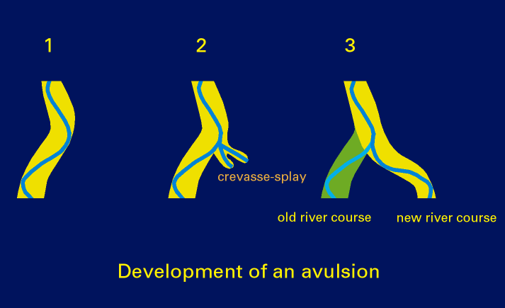
Avulsion typically occurs during large floods which carry the power necessary to rapidly change the landscape. Avulsions usually occur as a downstream to upstream process via head cutting erosion. If a bank of a current stream is breached a new trench will be cut into the existing floodplain. It either cuts through floodplain deposits or reoccupies an old channel. (wiki)
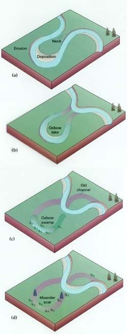
Meander
A meander, in general, is a bend in a twisting watercourse or river. A meander is formed when the moving water in a stream erodes the outer banks and widens its valley and the inner part of the river has less energy and deposits what it is carrying. A stream of any volume may assume a meandering course, alternately eroding sediments from the outside of a bend and depositing them on the inside. The result is a snaking pattern as the stream meanders back and forth. When a meander gets cut off from the main stream, an oxbow lake is formed.
Erosion
Erosion is the process by which soil and rock are removed from the Earth's surface by natural processes such as wind or water flow, and then transported and deposited in other locations.
**Logging requirements**
DO NOT POST ANSWERS IN YOUR LOG.
Send the following answers to me via email.
- The text "GC55VKX Avulsion of The Big Muddy" on the first line
- How high does the river need to rise before toppling this levy and adding more water to the oxbow lake to the east of the road? (Take an elevation reading at the posted cords and subtract 341 feet)
- How much of a shortcut is the river taking today versus in the past? (Measure the distance between waypoints "Stateline north & Stateline south, then subtract that from 5.35 miles.)
- Based on what you have read and what you see, do you think this is a "Erosional avulsion" or a "Meander"?
| I have earned GSA's highest level: |
 |