INTRODUCTION
The Philmont Scout Ranch (Philmont) in beautiful northeastern New Mexico serves as one of the Boy Scouts of America's (BSA) High Adventure Camps and Training Centers. Its history is old. Jicarilla Apache and Moache Ute Indians originally inhabited this area. The Beaubien and Miranda Land Grant then encompassed what is the present ranch. Prospectors and miners later arrived via the Santa Fe Trail when gold was discovered near Baldy Mountain. Eventually, Oklahoma oilman Waite Phillips amassed many acres of mountains and plains in a ranch he named "Philmont". Phillips believed in sharing his wealth and gave parts of his ranch to the Boy Scouts of America in 1938 and 1941 to serve as its national wilderness camp. In the summer of 2014, the 1,000,000th scout participated in the rugged challenge of the backpacking trek program. Its geological history is even older. Just as the BSA has a strong, century-old foundation in its Scout Oath and Scout Law, this New Mexico ranch has a strong, millions-years-old geological foundation. This EarthCache studies Philmont's mountainous foundation with its rocks and mesas.
You may locate the coordinates as a Philmont scouting participant, or as a visitor to the Ranch, or as a member of the public driving by. This Earthcache is located just off of state highway 21 at the entrance to Philmont Camping Headquarters. Please park safely, and watch out for scouts walking in the area.
EARTHCACHE LOGGING TASKS
To receive credit for this EarthCache, you must complete these Logging Tasks:
1. Standing at the coordinates, look to the West and identify the geological landmark that juts out from the expansive ridge. State what kind of rock it is.
2. Describe what you view geologically to the South, and explain how it was likely formed geologically.
3 .List at least 3 rocks that layered to form the Philmont area of New Mexico from what you can view at these coordinates.
It is not necessary for you to seek outside sources to complete these tasks; all information can be found here, or at the site.
Email your answers to me, separately from your log, which you may post right away as a "Find". If there is a problem, or if you have a question, then I will write back to you.
Enjoy continuing to learn about geology in your country and in the world. Plus, please take time to read about academic research that has been done to preserve our geological environment. And think about and share innovative ideas to promote and practice sustainability for our planet Earth.
EARTHCACHE RULES
When participating in EarthCache, you, the geocacher, agree to adhere to the principles of geocaching, Leave No Trace, and Outdoor Ethics. You also agree that the site must not be damaged, and that the fragile ecosystems must be respected. EarthCache visitors collect memories, not samples, from these virtual sites. No physical caches or other items are to be left at the EarthCache site. Learn about your earth's geology, protect it, and have fun.
GEOLOGY OF PHILMONT SCOUT RANCH, NM
Philmont Scout Ranch nestles in the foothills of the Sangre de Cristo Mountains of the Great Rocky Mountains where it meets the vast Great Plains to the East. The entire Philmont area may be viewed from the highway when coming from the town of Cimarron. The Cimarron Range, which has existed for 50 or 60 million years, rises suddenly from the plains of the Las Vegas Plateau. Mesas or benchlands as part of the Park Plateau separate the plains from the mountains. Eastward from the main mountain front is the light grey Tooth of Time Ridge; to its left, or South, is the Urraca Mesa. These two geological structures, plus the rock layers beneath the area, are the subjects of this EarthCache.
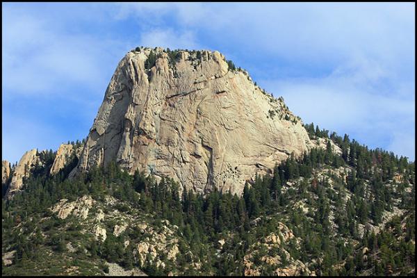
The Tooth of Time is Philmont's most recognizable geological landmark. At 9,000 feet, it is a granite monolith that protrudes 500 feet up from the Tooth of Time Ridge. It is a weathered outcrop of the dacite porphyry double Iaccolity of which the ridge is a part. This ridge, along with other ridges northwest of Philmont, is underlain by a swarm of overlapping laccoliths. There is a complicated pattern of alternating stripes of sedimentary rocks and of dacite porphyry formed in the Paleogene Period of the Cenozoic Era 22-40 million years ago.

The Urraca Mesa contains layered rocks of black shale. All the high ground, except for the mesa cap, is underlain by shale, then covered by soil, trees, slopewash, and landslides. Basalt lava poured from a now extinct volcano makes up the mesa cap which is comprised of a hard rock with many vertical cracks.

Philmont's sedimentary rocks appear layered, or piled up, in an orderly arrangement, though some sections are thicker or thinner than other sections. First, yellow sandstone and conglomerate are in a few thick layers separated by thinner layers of brown sandy shale. Second, beneath are alternating layers of yellow and gray sandstone, black shale, and coal, appearing in northern mesas. Third, even lower is light-gray sandstone with dark layers stained by dried oil. Fourth, below the sandstone, is black shale. Black shale is mainly beneath the plains and not in the core of the mountain.
Rocks beneath the plains are gravel and sand; black shale and orange shale; gray limestone; dark mica-rich lamprophyre; and brown andesite. Rocks of the mesas are yellow sandstone and conglomerate; light-gray sandstone; shale; dark basalt; dacite porphyry; andesite; and coal. Rocks of the mountains are spotted dacite prophyry; striped gneiss and schist; garnet schist; quartzite; diorite porphyry; pink ranodiorite; yellow and gray quartz sandstone; red sandstone and conglomerate; red shale and black shale; limestone conglomerate; basalt; red bomb beds; pepper-and-salt diorite; and rubble.
MINIMAL ECOLOGICAL IMPACT ON PHILMONT
This EarthCache not only celebrates the geological splendor of this New Mexico region, but reminds geocachers of the commitments by Philmont Scout Ranchto preserve and sustain the fragile resources of our Earth.
EarthCaches also celebrate three other BSA high adventure bases:
FLORIDA SEA BASE in Florida (GC6A0NH)
SUMMIT BECHTEL RESERVE in West Virginia (GC4KE2X)
NORTHERN TIER in Minnesota (GC6Z77E)
Try to find time to visit these EarthCaches to experience a bit of how high adventure expeditions affect youth and geocachers alike. Outdoor challenges shape youth and teach them about themselves. High adventure EarthCaches unveil geological magnificence and teach you about your Earth. Both activities emphasize the sustainability of our fragile environment.
SOURCES
Balk, Robert (1953). "Geologic Guide to the Trails at Philmont Scout Ranch".
Philmont Scout rand, "Philmont Adventures" (2014).
Robinson, G.D., A.A.Wanek, W. H. Hays and M. E. McCallum (1964).
"Philmont Country: The Rocks and Landscape of a Famous New Mexico
Ranch", U.S. Geological Survey, Professional Paper 505. retrieved May
25, 2014 at http://pubs.usgs.gov/pp/pp_505/html/pdf.html
AnnScout thanks Benjamin Sanders for his IT assistance for this EarthCache