 ;
;
The Trust commits to promote and safeguard these assets for all the residents of, and visitors to, Herefordshire and Worcestershire.
This Earthcache is a short walk around Tank Quarry. It will take less than an hour to visit the sites indicated.
The iconic Malvern Hills form a natural boundary between Worcestershire and Herefordshire stretching some 14km and rising to around 450m at the highest point. They are comprised of rock forged from volcanic activity (aka igneous rock) and subsequent movement and upheaval (which produced metamorphic rocks). The geology of the Malvern Hills is very complex but the rocks are generally physically very hard and commonly find use as construction materials. Much of the rock quarried from the Malverns was used as road aggregate, as it is well-suited for coating with bitumen, and to a lesser extent building. Thus there are numerous disused Quarries on the Malvern Hills and, of these, Tank Quarry is one of the largest and was named after a water tank built on the hillside in 1835.
Tank Quarry
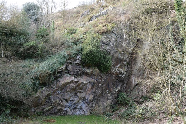
Situated on the north-eastern side of North Hill, the quarry faces are approximately 100m in height and are 80m wide at the base. At the front of the quarry there is a small car park with a picnic area, just past the clock tower. There is also a small geology trail that leads up the eastern edge of the site, where a viewing point is located. The main cache coordinates take you to the car park
The quarry was worked from c1870 to 1970 with increasing local concern that North Hill itself might be destroyed. Since its closure, it has slowly ceded to nature with Silver Birch, Buddleia and Rowan now thriving in the quarry,
Much of the quarry is fenced off due to dangerous rock faces and unstable cliff edges; however, there are some areas behind the picnic area, which allow visitors to view the geology safely. From the eastern edge of quarry, the landscape of Worcestershire can be viewed, with the prominent Cotswolds and Bredon Hill made of Jurassic-age limestones visible to the south-east. To the north-east the Ordovician-age Lickey Hills and Permian-age Clent Hills can be seen. To the east the flat plain underlain by Triassic-age sandstones has given rise to the rich agricultural landscape of Worcestershire.
Tank Quarry Geology
The geology of Tank Quarry dates to the Precambrian, around 680 million years ago, which means that these rocks are some of the oldest exposed in England. During their formation, the continents would have been completely different to today and Tank Quarry would have sat around 60° south of the equator.
The rock types found here are Diorite and Granite, formed as a consequence of material melting to produce magma (underground lava). Both coarse and fine-grained examples can be found here; slow cooling forms fine-grained rock whereas coarse-grained rock appears if cooling had been rapid.
A short Tour of Tank Quarry
Location 1: Quartz Vein and Information Boards
From the Car Park, head to approx. N52 07.313 W002 20 340 (it's an upright board, a little beyond the horizontal information boards); here you will find information about the thickest vein of quartz found on the Malverns – it’s just in front of you. The glassy pink-white Quartz is formed when, under very high temperatures and pressures, water dissolves minerals which subsequently crystallise along the surfaces of fractures in the rock, forming veins. The six other information boards nearby provide information about the prevailing geology of the area.
Location 2: The Clock Tower
In 1843 part of the clock tower was constructed to house a spout which diverted water from the North Malvern Spring. Water was collected in a series of tanks behind the tower, hence Tank Quarry. Both the original water tank and the clock tower were built by Charles Morris, a local benefactor, to provide a public water supply to local residents. A great example of the use of Diorite is in the basin inside the clock tower. Note that behind the font is a slab of marble (a metamorphic rock) and behind that is sandstone (sedimentary rock).
Over the road from the clock tower is Milestone House; note where walls are formed of a variety of randomly shaped rock secured by mortar. This is a classic example of wall building in the Malvern area. The rock is too hard to easily shape so a patchwork of pieces is formed and bricks or blocks of softer stone which can be more-easily shaped are used to form corners or wall-ends.
Location 3: Small Quarry & Viewpoint
Behind the clock tower, you will find a path running uphill; after a very short ascent, you should soon spot a set of very straight steps almost directly in front of you. This is not one of the earthcache locations but the steps emerges in a small quarry which makes a lovely secluded spot for a picnic. Should you visit this quarry, there’s a good example of a geological 'fault' to the right at the far end of the rock face – it’s the large crevice – please note the risk of falling rock around that point and keep your distance.
Whether or not you tackled the straight steps, you need to follow the path uphill round to the left, it is uneven but has railings running alongside. You may spot numerous blocks of pink granite underfoot.
At approx. N52 07.248 W002 20.267 (amongst several suitable viewpoints on that section of path), you should have a glorious view of the Severn Vale; this is underlain by red Triassic Sandstone and Mudstone with the limestone features of Clent, Bredon Hill and the Cotswolds visible in the distance.
This marks the end of the earthcahe but continuing up this path will eventually take you up to the top of North Hill
To log this cache, please send answers to the following questions via the profile link above:
Question 1:: The quartz vein found at this location is effectively a very large crystal formed from many smaller crystals. Can you identify where you may also commonly find quartz. How would its appearance differ to that of the vein at Tank Quarry?
Question 2: Diorite, like that used to make the basin in the tower, is not commonly worked to produce items with a definite shape; why do you think that might be?
Question 3: Describe briefly, the key, naturally-occurring, features you can see from the viewpoint; why do you think features such as the Malverns and the other hills remain prominent in this area?
Safety: As with any site of this nature, please remain on the public paths, watch your footing, observe safety signs and do not damage any rock faces – stay safe!
