The Stone Pool of Cala Llamp
DEUTSCH:
ENTSTEHUNG DER INSEL
Mallorcas Entstehung ist eng mit der alpidischen Orogenese und der Formung unseres heutigen Mittelmeeres verknüpft.
Während des Paläozoikums formten die heutigen Kontinente zusammen einen Urkontinent, der als Pangaea bezeichnet wird. Umgeben wurde Pangaea von dem Urmeer Panthalassa. Ein Teil des Urmeeres stellt das Tethysmeer als schenkelförmige Einbuchtung, die vom heutigen Spanien bis etwa zum Irak sowie von Tunesien bis zur arabischen Halbinsel reichte, dar.
Vor rund 200 Mio. Jahren brach Pangaea letztlich auseinander und nach und nach ordneten sich die Kontinentalplatten so an, wie wir sie heute beobachten. Eine ausführliche Beschreibung der Bewegungen der einzelnen tektonischen Platten würde an dieser Stelle zu weit führen, sodass sich die folgenden Ausführungen auf die afrikanische und eurasische Platte sowie das Tethysmeer beschränken.
Die afrikanische Platte bewegte sich nach dem Auseinanderbrechen Pangaeas in Richtung Norden. Diese Bewegung war auf der östlichen Seite der Platte stärker ausgeprägt als im Westen, sodass eine langsam rotierende Bewegung zustande kam. Dadurch verengte sich das Tethysmeer besonders im Osten wodurch es die Gestalt einer Meerenge zwischen Afrika und Eurasien erhielt, die den Atlantik mit dem Indischen Ozean verband. Durch die anhaltende nordwärts gerichtete Drehbewegung Afrikas wurde schließlich die Öffnung des Tethysmeeres zum Indischen Ozean geschlossen, so dass ein Restmeer übrig blieb, welches wir heute als Mittelmeer bezeichnen.
Nicht nur die Entstehung der Form unseres heutigen Mittelmeeres ist eng mit der Bewegung der afrikanischen Platte verknüpft, sondern auch die Entstehung der Alpen.
Im Zeitalter des Jura, also bevor die nordwärts gerichtete Bewegung der afrikanischen Platte einsetzte und das Tethysmeer noch relativ breit war, kam es zu einer massiven Sedimentation von Kalk im Tethysmeer. Der Kalk, der aus abgestorbenen anorganischen Bestandteilen von Meeresorganismen stammt, lagerte sich in mächtigen Schichten in der sogenannten Geosynklinale der Tethys ab, welche eine langgestreckte, absinkende Sedimentationsmulde darstellt. Im Laufe der Jahrmillionen verfestigte sich der Kalk zu Kalkstein und durch Einlagerung von Magnesium in die Kristallstruktur auch zu Dolomit.
Mit dem Beginn der Bewegung der afrikanischen Platte vor etwas mehr als 100 Mio. Jahren begann auch die Subduktion der Platte unter die eurasische Platte. Als Resultat dieser Bewegung kam es zu einer starken Auffaltung sowohl des alten Grundgebirges als auch der mächtigen Sedimentationsschicht aus der Geosynklinalen. Die Mächtigkeit der jurassischen Kalksedimente lässt sich erahnen, wenn man bedenkt, dass weite Teile des alpidischen Gebirgsgürtels aus Kalkstein bestehen.
Neben der starken Auffaltung des Bereichs kam es auch zu einer massiven Emporhebung. Zu dem Gebirgsgürtel, der durch die beschriebenen Vorgänge entstanden ist, gehören neben den Alpen auch das Atlasgebirge auf afrikanischer Seite (Marokko), die betische Kordilliere in Südostspanien, die Pyrenäen, der Apennin, die Karpaten und das dinarische Gebirge der Balkanländer.
Da die Balearen als Teil der betischen Kordilliere, die zwischen den Balearen und dem spanischen Festland unter dem Meeresspiegel verlaufen, angesehen werden können, sind sie also ebenfalls ein Produkt der alpidischen Orogenese.
Mallorca lag vor 100 Mio. Jahren als Bestandteil der kontinentalen eurasischen Platte als große ebene Fläche vor, die im Zuge der alpidischen Auffaltung zusammengepresst wurde und sich dabei um 55 % verkleinerte. Dabei bildete sich die heutige orographische Struktur der Insel.
Im Tertiär stiegen aufgrund höherer Temperaturen die Meeresspiegel an und die flachen, tief gelegenen Regionen Mallorcas wurden dauerhaft vom Meer überflutet, sodass nur die Gebirgszonen aus dem Meer hervorragten.
Als im Quartär die Temperaturen absanken und sich an den Polkappen mehr Eis ansammelte, sanken die Meeresspiegel rapide ab und das mallorquinische Flachland "erhob" sich über den Meeresspiegel. Während der Eiszeiten lag der Meeresspiegel im Mittelmeer bis zu 100 Meter unter dem heutigen Wasserstand und deshalb umfasste die Insel im Pleistozän eine größere Fläche als in unserem Zeitalter. Heute beträgt die Fläche Mallorcas etwa 3640 km2.
GENAUERE ENTSTEHUNG DER CALA LLAMP:
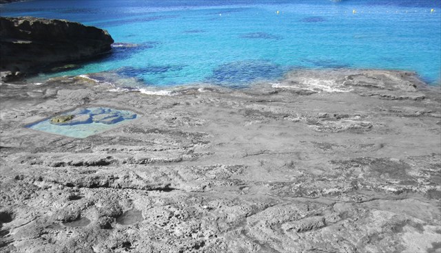
Die Cala Llamp Bucht an den Listing Koordinaten ist eine felsige Bucht, bei der die Küstenregion schlagartig steil abfällt. Der untere Bereich am Wasser ist bis auf zwei größere Felsvorsprünge sehr flach. Nach ungefähr 20 Metern geht es dann jedoch ganz steil hoch. An den Steilhängen kann man Schichten von Sandstein erkennen. Der untere Bereich, der regelmäßig von Wasser überspült wird, dagegen ist aus gefestigtem Kalkstein, denn hier wurde der weiche Sandstein nach und nach ausgewaschen und es können sich immer wieder Mikroorganismen absetzen, die über Calciumcarbonat neuen harten Kalkstein bilden.
Übrig geblieben ist eine flache Fläche mit verschiedenen kleinen Anhöhen und Mulden.
Eine besondere Mulde, die gebildet wurde, ist der namensgebende „Swimming Pool“. Das Wasser hat mit den verschiedenen Strömungseinflüssen in die Bucht ein nahezu exakt quadratisches Loch ausgespült.
Das es zu dieser quadratischen Aushöhlung kam liegt jedoch nicht nur an den Strömungseinflüssen, sondern spiegelt auch wieder, dass der Sandstein nicht ausschließlich in Schichten sondern auch sehr lokal zentriert im Ursprungsgestein vorkam.
Zur genaueren Erläuterung haben wir einmal zwei Skizzen angefertigt:
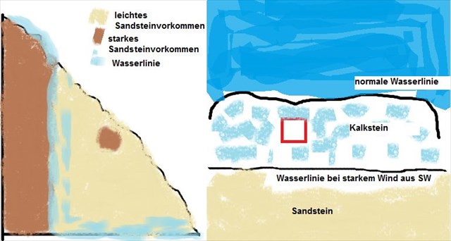
Wenn man sich nun beide Skizzen genauer ansieht, kann man feststellen, dass dort, wo das stärkere Sandsteinvorkommen war, noch heute Sandstein zu sehen ist. In dem Bereich, wo früher deutlich weniger Sandstein war, war es einfacher Kalkstein aus Mikroorganismen zu bilden.
Obwohl an dem „Pool“ ebenfalls ein stärkeres Sandsteinvorkommen vorherrschte, konnte hier alles abgetragen werden, da dieser Bereich bei passenden Wind- und Strömungsverhältnissen unterhalb der Wasserlinie liegt. So wurde im Laufe der Jahrtausende alles ausgespült und Mikroorganismen setzen sich ab die Kalkstein bildeten.
Heute kann man bei leichteren Winden herrlich in dem kleinen Becken planschen. Da immer wieder ein Austausch mit dem Meerwasser stattfindet, sind auch jederzeit Tiere zu entdecken.
Nun zu den Aufgaben:
1: Begib dich zu den angegeben Koordinaten und schätze/messe die Ausmaße des Pools.
2: Bei welcher Windrichtung wird der Pool von Wellen überspült?
3: Beschreibe die Gesteinsfarben um den Pool herum.
4: Nenne drei hier vorkommende Lebewesen
Über ein freiwilliges Logfoto würden wir uns freuen.
Schicke deine Antworten bitte über das GC Profil. Du darfst dann sofort loggen, sollte etwas nicht stimmen, werden wir uns melden.
English:
Creation OF THE ISLAND
Mallorca's emergence is closely linked to the alpidischen orogeny and the formation of our present-day Mediterranean Sea.
During the Paleozoic, the present continents formed a supercontinent together, which is called Pangaea. Pangaea was surrounded by the primeval ocean Panthalassa. Part of the primordial ocean represents the Tethys Sea as leg-shaped depression, which reached from Spain today to about Iraq and Tunisia to the Arabian Peninsula, dar.
Before about 200 million years ago, Pangaea broke apart eventually and gradually the continental plates arranged in such a way as we observe it today. A detailed description of the movements of the individual tectonic plates would lead too far at this point, so that the following statements refer to the African and Eurasian plate and the Tethys Ocean.
The African plate moved to the breakup of Pangaea in the north. This movement was more pronounced on the eastern side of the plate than in the West, so that a slowly rotating movement came about. Thus, the Tethys Ocean particularly in the east narrowed whereby it received the form of a strait between Africa and Eurasia, connecting the Atlantic to the Indian Ocean. The continuing northward rotational motion of Africa, finally, the opening of the Tethys Sea to the Indian Ocean was closed, so that a residual sea remained, which we call the Mediterranean today.
Not only the origin of the shape of our today's Mediterranean Sea is closely linked to the movement of the African plate, but also the formation of the Alps.
In the age of the law, that is, before the northward movement of the African plate began and the Tethys Ocean was relatively wide, there was a massive sedimentation of lime in the Tethys Ocean. The lime comes from dead inorganic constituents of marine organisms, encamped in powerful layers in the so-called geosyncline Tethys from showing an elongated, sinking Sedimentationsmulde. Over millions of years, the lime solidified to limestone and by the incorporation of magnesium in the crystal structure also dolomite.
With the onset of movement of the African plate years ago, a little over 100 million, the subduction of the plate under the Eurasian plate began. As a result of this movement, there was a strong folding of both the old basement and the mighty sedimentation of the geosyncline. The thickness of the Jurassic carbonate sediments can be guessed, considering that large parts of the mountain belt alpidischen consist of limestone.
In addition to the strong folding of the area, there was also a massive upheaval. To the mountain belt, which is caused by the described processes belong next to the Alps and the Atlas Mountains, on the African side (Morocco), the Betic Cordillera in south-eastern Spain, the Pyrenees, the Apennines, the Carpathians and the Dinaric mountain range in the Balkans.
Since the Balearic Islands can be considered part of the Betic Cordillera, which extend between the Balearic Islands and the Spanish mainland below sea level, so they are also a product of alpidischen orogeny.
Mallorca was 100 million years ago as part of the continental Eurasian plate as a large flat area before, which was compressed during the alpidischen unfolding and thereby reduced by 55%. Here, the present orographic structure of the island was formed.
In the Tertiary due to higher temperatures rose to the sea and the flat, low-lying regions of Mallorca were permanently flooded by the sea, so that only the mountainous areas rising out of the sea.
As in the Quaternary plummeted temperatures and accumulated more ice at the poles, sea levels fell off rapidly and the Majorcan plains "raised" over the sea level. During the ice ages up to 100 meters in the Mediterranean sea level was below the present water level and therefore the island comprised in the Pleistocene a larger area than in our age. Today the area of Majorca about 3640 km2.
ACCURATE Creation OF CALA LLAMP:
The Cala Llamp bay on the listing coordinates is a rocky bay, in which the coastal region falls abruptly steep. The lower portion of the water is down to two large rocky outcrops very flat. After about 20 meters turn but then very steeply. The steep slopes you can see layers of sandstone. The lower section which is regularly washed over by water, however, is from gefestigtem limestone, because here the soft sandstone was gradually washed out and it can always settle microorganisms that form on new hard calcium carbonate limestone.
What remains is a flat surface with several small hills and valleys.
A special tray that has been formed, the eponymous "Swimming Pool". The water has flushed with the various influences flow into the bay a nearly exact square hole.
However, it came to this square cavity is not only because the flow influences, but also reflects again that the sandstone occurred not only in layers centered but also very locally in the source rock.
For a more detailed explanation, we would have even made two sketches:
Now if you look at both sketches closely, you can see that where the stronger sandstone deposits was today sandstone can be seen. In the area where previously much less sandstone was, it was easier to form limestone from microorganisms.
Although in the "pool" also prevailed a stronger sandstone deposits could be removed everything, as this area is suitable wind and flow conditions below the water line. So everything was flushed out over the millenniums and microorganisms settle on the limestone formed.
Today, you can delightfully splashing in the small pool in lighter winds. As always held an exchange with the sea water, at any time animals are to be discovered.
Now for the tasks:
1: Embark at the indicated coordinates and estimate / measure the dimensions of the pool.
2: At what wind direction, the pool is washed over by waves?
3: Describe the rock colors around the pool.
4: Name three living things occurring here
From a voluntary Logfoto we would be pleased.
Send your answers please use the GC profile. You may then login immediately, should be something wrong, we will contact you.
Spanish:
TRABAJO DE LA ISLA
El surgimiento de Mallorca está estrechamente vinculada a la orogenia alpidischen y la formación de nuestra actual mar Mediterráneo.
Durante el Paleozoico, los continentes actuales formaban un supercontinente juntos, que se llama Pangea. Pangea estaba rodeado por el océano primigenio Pantalasa. Parte del océano primordial representa el mar de Tetis como depresión en forma de pata, que llegó de España en la actualidad a cerca de Irak y Túnez para la Península Arábiga, dar.
Antes de hace unos 200 millones de años, Pangea se rompió finalmente y poco a poco las placas continentales dispuesto de tal manera que observamos hoy en día. Una descripción detallada de los movimientos de las placas tectónicas individuales llevaría demasiado lejos en este punto, por lo que los siguientes se refieren a la placa africana y la euroasiática y el mar de Tetis.
La placa africana se trasladó a la ruptura de Pangea, en el norte. Este movimiento fue más pronunciada en el lado oriental de la placa que en el Oeste, por lo que un movimiento de rotación lenta se produjo. Por lo tanto, el Océano Tetis especialmente en el este se redujo por la que recibió la forma de un estrecho entre África y Eurasia, que conecta el Atlántico con el Océano Índico. El continuo movimiento de rotación hacia el norte de África, por último, la apertura del Mar de Tetis hasta el Océano Índico estaba cerrado, así que un mar residual se mantuvo, lo que llamamos el Mediterráneo hoy.
No sólo el origen de la forma de del día de hoy del Mar Mediterráneo está estrechamente vinculada con el movimiento de la placa africana, sino también la formación de los Alpes.
En la era de la ley, es decir, antes de que el movimiento hacia el norte de la placa africana comenzó y el Océano Tetis fue relativamente amplio, había una sedimentación masiva de cal en el mar de Tetis. La cal proviene de constituyentes inorgánicos muertos de los organismos marinos, acampados en las capas poderosas en el llamado geosinclinal Tethys de mostrar una alargada, hundiéndose Sedimentationsmulde. Durante millones de años, la cal solidificada a la piedra caliza y por la incorporación de magnesio en la estructura cristalina también dolomita.
Con el inicio del movimiento de las placas hace años africanos, poco más de 100 millones de dólares, la subducción de la placa de debajo de la placa euroasiática comenzó. Como resultado de este movimiento, se produjo un fuerte plegamiento de tanto el antiguo sótano y el poderoso sedimentación del geosinclinal. El espesor de los sedimentos carbonatados del Jurásico se puede adivinar, teniendo en cuenta que gran parte de la cadena montañosa alpidischen consisten en piedra caliza.
Además de la fuerte plegado de la zona, también hubo una agitación masiva. Para la cadena montañosa, que es causada por los procesos descritos pertenecen al lado de los Alpes y las montañas del Atlas, en el lado africano (Marruecos), la Cordillera Bética en el sureste de España, los Pirineos, los Apeninos, los Cárpatos y la cordillera Dináricos en los Balcanes.
Desde las Islas Baleares se puede considerar parte de la Cordillera Bética, que se extienden entre las Islas Baleares y la península española bajo el nivel del mar, por lo que son también un producto de la orogenia alpidischen.
Mallorca fue hace 100 millones de años como parte de la placa de Eurasia continental como una gran zona plana antes, que se comprime durante el alpidischen despliegue y con ello reduce en un 55%. Aquí, se formó la actual estructura orográfica de la isla.
En la era terciaria debido a mayores temperaturas se elevaron hasta el mar y las regiones planas, bajas de Mallorca fueron inundadas permanentemente por el mar, por lo que sólo las zonas de montaña que sube del mar.
Al igual que en el Cuaternario desplomado temperaturas y acumulado más de hielo en los polos, los niveles del mar se cayeron rápidamente y las llanuras de Mallorca "levantados" sobre el nivel del mar. Durante la edad de hielo de hasta 100 metros en el nivel del mar Mediterráneo estaba por debajo del nivel actual del agua y por lo tanto la isla constan en el Pleistoceno un área mayor que en nuestra época. Hoy en día la zona de Mallorca a unos 3.640 km2.
Trabajo preciso de Cala Llamp:
La bahía de Cala Llamp en las coordenadas de la lista es una bahía rocosa, en la que la región costera cae abruptamente empinado. La parte inferior de las aguas se ha reducido a dos grandes afloramientos rocosos muy planas. Después de unos 20 metros gire pero luego abruptamente. Las pendientes pronunciadas se puede ver capas de piedra arenisca. La sección inferior que se lava con regularidad durante por agua, sin embargo, es de piedra caliza gefestigtem, porque aquí la piedra arenisca suave se lavó gradualmente y siempre puede resolver los microorganismos que se forman en la nueva piedra caliza carbonato cálcico duro.
Lo que queda es una superficie plana con varias pequeñas colinas y valles.
Una bandeja especial que se ha formado, el homónimo "Swimming Pool". El agua ha barrido con las diversas influencias fluyen en la bahía un agujero casi exacta cuadrado.
Sin embargo, se llegó a esta cavidad cuadrada no es sólo debido a las influencias de flujo, pero también refleja una vez más que la piedra arenisca se produjo no sólo en capas centradas pero también muy a nivel local en la roca madre.
Para una explicación más detallada, habríamos incluso hizo dos dibujos:
Ahora bien, si nos fijamos en los dos bocetos de cerca, se puede ver que, cuando fue la piedra arenisca se pueden ver hoy los depósitos de arenisca más fuertes. En el área donde fue mucho menos con anterioridad piedra arenisca, fue más fácil para formar caliza de microorganismos.
Aunque en el "pool" también prevalecido unas depósitos de arenisca más fuertes pueden ser destituidos de todo, ya que esta zona es de las condiciones adecuadas de viento y de flujo por debajo de la línea de agua. Así que todo se inundó a lo largo de los milenios y los microorganismos se asientan en la piedra caliza formado.
Hoy en día, usted puede deliciosamente chapoteando en la piscina pequeña en vientos más ligeros. Como siempre mantuvo un intercambio con el agua de mar, en cualquier momento los animales están por descubrir.
Ahora, para las tareas:
1: Embárcate en las coordenadas indicadas y estimación / medir las dimensiones de la piscina.
2: En qué dirección del viento, la piscina se bañó por las olas?
3: Describir los colores de roca alrededor de la piscina.
4: Nombra tres cosas vivas que ocurren aquí
Desde un Logfoto voluntaria estaremos encantados.
Envíe sus respuestas por favor utiliza el perfil de GC. Puede luego ingresar inmediatamente, debe haber algo mal, nos pondremos en contacto con usted.
