Stoke Newington Common
This easy multi which should take less than 30 minutes to complete will take you on a short tour around this small Common. The cache, a small screw-topped camo-pot, is hidden on the western side of this (although dissected by rail and road links) green and pleasant patch of north London. As always in such locations, beware of observation by muggles during retrieval and replacement, and please replace carefully ensuring proper concealment - hopefully as when found.
To find the cache:
Step 1: Go to the given coordinates where you will find a recently restored water fountain. A = the alphanumeric (A=1, B=2, C=3 etc) value of the 1st letter of the first name of the lady commemorated on the fountain plaque.
29/8/23 update: as the plaque has apparently gone, use A=6
Step 2: Now move to nearby N 51 33.740 W 000 04.103 where you will find an information sign with a map of the trees of the Common - an impressive 33 different species - also found in the cache Gallery. Using the map, locate the legend explaining all the tree abbreviations used on the map. For the abbreviation Bh, B = the alphanumeric value of the 1st letter of the second word of the name of this tree.
Step 3: On to N 51 33.745 W 000 04.153 where you will find some wooden information boards. From these you will learn that the oldest surviving houses in the area are those in Sanford Terrace on the west side of the Common which were built from 178C-90.
(Update Nov 2021: it is reported that with deterioration of the info boards, the required info is no longer legible, but fortunately the required year can be found in the geocache description)
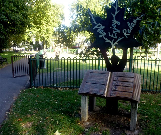
Step 4: Move a short distance south alongside the playground to N 51 33.735 W 000 04.158 . On your left you will see D tyre swings
(Update Sep 2016: One of the tyre swings has been reported as missing, so use the total tyre swings - including the missing one/s)
(Update March 2024: it has been reported that the missing swing is now back in action!)
Step 5: Now head across the main grassy area to the popular resting place at N 51 33.727 W 000 04.198. The number of wooden legs supporting the semi-circular bench = J
(Update March 2024: it has been reported that the bench has gone so use J=14)
Step 6: Proceed now to N 51 33.702 W 000 04.183. E = the number of links in the chain joining the 3rd and 4th wooden posts from the rail bridge
Step 7: Onwards to N 51 33.713 W 000 04.230 where you will find a memorial commemorating a Turkish tragedy (see here for details). F = the value of the 4th letter of the first name of Mr Ozyurt.
Step 8: From here continue a short distance to N 51 33.740 W 000 04.246 where you will find a single small metal Thames Water cover. The value of the large capital letter on the cover = G
(Update Aug 2016: The cover is still there but it was partially obscured by leaves and dust. So you may have to look around a little if this recurs)
Step 9: Onwards a short distance to N 51 33.761 W 000 04.240 where you will see a green wall plaque. The number of words which are written horizontally = H
The cache can be found at the following final coordinates:
N 51 33.(E-G+1)(H-D)(J-8) W 000 04.(F-B-1)(B+1)(C-A+5)
History of the Common
This 2.15 hectares (5.3 acres) area is old common land that became publicly owned in 1872 when the current paths and trees were established. It was originally called Cockhanger Green later became Shacklewell Common, but Shacklewell's reducing sphere of influence led to it being called Newington Common for a time (not to be confused with Newington Green) then finally in the early 20th century it got its current name.
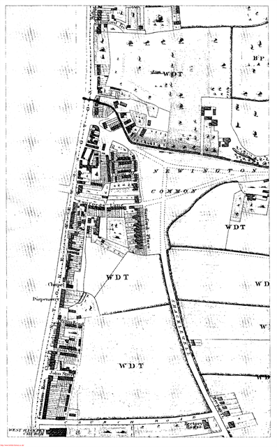 Historically, it was used for pasture throughout the year and used to be much larger before strips around the edge were enclosed for private use in the 18th and 19th Centuries. Several early maps can be found in the Hackney Archives (see gallery photos).
Not only was its name mangled by time, unlike the nearby Hackney Downs this land has been dissected by London's Victorian transport links. The deep railway cutting of the line between Stoke Newington and Rectory Road stations runs straight through the common from north to south, while the parallel Rectory Road (part of the A10 gyratory) slices off another strip to the west. Finally the road called Stoke Newington Common, a busy bus route, chops off a section to the south.
Hackney Brook used to run across the north of the Common, along what is now Northwold Road, turning south at the eastern tip of the Common to run down and across Mare Street. The brook was first canalised and then buried in the late 19th Century, following concerns that the increasing population had reduced it no more than an open sewer.
The earliest housing around the Common was on the west side. Sanford Terrace is the only surviving stretch of the terraces built in 1788–90, which ran along the entire length until the 1970s, when they were demolished to make way for the Smalley Road Estate. As late as 1868, the area to the north and south was still fields, market gardens and three large houses.
When speculative development in terraced avenues commenced in the 1870s, first in the streets south of the Common, then in the market gardens to the north, the area was discovered by W.G. Smith in 1878 to be an important Paleolithic flint axe factory site. Excavations revealed many tools dated to 400,000 years ago, now in the Museum of London.
This Palaeolithic floor is part of an ancient terrace carved by the River Thames called the Upper Taplow Terrace that stretches from Stoke Newington past Canonbury to Rosemary Branch. It is a remnant of a plain where extensive evidence of the earliest human occupation of Britain has been found, notably at Swanscombe, Kent.
The north side of the common was overlooked by Gibson Gardens, an early example of quality tenement dwellings for the working-class. Built in 1880 and unchanged since, some parts are highly desirable for owner-occupiers. It is now hidden from the common by the 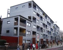 innovative and award-winning Raines Court on Northwold Road on the site of the old dairy. Built in 2003 by the Peabody Trust, this is only the second multi-storey modular housing development in Britain and offers one approach to increased housing demand in the area.
Local residents have campaigned unsuccessfully for many years to have Rectory Road closed off over the common and the railway cutting roofed over. By now the huge cost of the works which would be needed has reduced the chances of success to zero.
The common had at least one internationally famous resident - Marc Bolan of the band T. Rex, who lived at 25 Stoke Newington Common, until he was 15. There is a commemorative plaque on the wall (see Gallery).
The three roads which dissect the Common (Northwold Road, Rectory Road and Stoke Newington Common) have been in approximately the same location for at least 300 years, connecting Stamford Hill with Clapton and Shacklewell, but they have only had motorised traffic in the last 50 years.
The common has an extensive collection of trees with some 33 species (if my count is correct) to be found some in fully mature form, others planted as recently as 2008 (see the Tree Map in the gallery).
See here for information on activities and developments relating to the Common
See here for more info on the Common in a 2010 Conservation Area appraisal report.
Use the link below to check your calculated coordinates for the final . . .
