Skip to content

Endmoränen - Reste der Eiszeit EarthCache

Hidden : 8/4/2014
Difficulty:
2 out of 5
Terrain:
2 out of 5

Size: Size:   other (other)

Join now to view geocache location details. It's free!

Watch

How Geocaching Works

Please note Use of geocaching.com services is subject to the terms and conditions in our disclaimer.

Geocache Description:

I have earned GSA's highest level:


Endmoränen - Reste der Eiszeit


Ein Berg aus Schutt - Die Moräne

oder

Der Gipfel von Maasholm – Eine Bergwanderung in Schleswig-Holsteins Osten

Einleitung

Mit diesem EarthCache wollen wir euch zu einer ganz besonderen Erfahrung einladen:

Einer Bergtour in Schleswig-Holstein!
Dies ist nur im Osten Schleswig-Holsteins möglich. Warum?

Dazu müssen wir tiefer in die Landschaften und die Entstehungsgeschichte Schleswig-Holsteins eintauchen.

Schleswig-Holstein kann grob in drei verschiedene Landschaftsformen unterteilt werden, die alle von Nord nach Süd verlaufen.

Im Westen zur Nordsee hin die Marsch als ein weitgehend nacheiszeitlich und marin entstandener Großraum sowie das Wattenmeer.

In der Mitte dann die Geest, ein Gebiet mit vorwiegend sandigen Böden. Zum Marsch-Gebiet hin findet sich Moränenmaterial der Saale-Warthe-Moräne.

Im Osten, hier vor Ort beim EarthCache, finden wir das sogenannte Hügelland.

Es ist die jüngste der drei Landschaftsformen, entstanden durch mehrere, sehr dicht beieinander liegende Eisrandlagen der Weichsel-Eiszeit, die der Landschaft seinen hügeligen Charakter durch Endmoränenzüge gegeben hat. Das von Nordosten kommende Eis schob Lockermaterial vor sich her und lagerte es ab.

Aber nun zum EarthCache (unserer Bergtour)!
Ihr startet am besten beim Naturerlebniszentrum (ist ausgeschildert und gut zu finden, ihr fahrt daran vorbei wenn ihr nach Maasholm fahrt). SEHR EMPFEHLENSWERT !

Oder ihr startet an einem der vielen Parkplätze direkt in Massholm.

Das Ziel an den Cache-Koordinaten ist die Spitze einer eiszeitlichen Endmoränenablagerung.

So oder so ähnlich könnte es hier einmal ausgesehen haben

Unter Moränen versteht man alles Material, welches von einem Gletscher transportiert wurde. Gemeint sind die Schuttablagerungen, die von den Gletschern bei ihrer Bewegung mitbewegt oder angehäuft wurden.

Grundsätzlich werden zwei Arten von Moränen unterschieden:

Wandermoränen und abgelagerte Moränen.

Wandermoränen wurden vom Eis bewegt.

Hierzu gehören die Obermoränen, Innenmoränen, Untermoränen, Seitenmoränen, Mittelmoränen und Geschiebe.

Obermoränen stammen von dem Material, das von den Felswänden auf den Gletscher gestürzt ist und sich beim Schmelzen des Gletschers abgelagert hat.

Innenmoränen umfassen alles Material, das im Inneren des Gletschers transportiert wurde.

Untermoränen bilden sich an der Gletscherbasis. Das Material der Untermoräne wird durch die Reibung mit dem Untergrund sehr stark geschliffen und zerkleinert.

Seitenmoränen bilden sich entlang der Ränder der Gletscherzunge. Ihr Material stammt einerseits von dem seitlich anstehenden Gestein, zum Großteil aber aus ehemaligen Untermoränen, die an die Seiten des Gletschers geführt wurden.

Mittelmoränen entstehen aus den Seitenmoränen zweier Gletscher, wenn diese zusammenfließen und sich vereinen.

Geschiebe ist alles Material, welches vom Eis bewegt wurde.

Abgelagerte Moränen wurden nicht mehr weiter bewegt.

Hierzu gehören die Grundmoränen und die Endmoränen.

Grundmoränen bestehen aus dem Material der Unter- und Innenmoränen.

Endmoränen bilden sich als Schuttanhäufung am Gletscherende, wenn sich die Gletscherstirn für längere Zeit nicht bewegt. An ihnen kann man besonders gut die größte Ausdehnung des Gletschers erkennen.

Der Wall aus Sand und Steinen ist die Endmoräne

Nach der Entstehungszeit werden Jungmoränen (Weichseleiszeit, Würmeiszeit) von Altmoränen (aus den vorherigen Eiszeiten) unterschieden.

Der Begriff Moräne umfasst alle Schuttmassen, die durch das Eis mitgeführt und abgelagert wurden. Moränen bestehen dabei aus Material verschiedener Körnungsgröße, vom Ton über Sand bis zu größeren Gesteinsblöcken. Das Material ist jedoch durchmischt und weist in der Regel keine Sortierung nach der Größe auf.

Beispiele für Ablagerungsmaterial

An den Cache-Koordinaten befindet ihr euch auf der Spitze einer eiszeitlichen Endmoränenablagerung.

Von hier habt ihr einen tollen Ausblick über die Ostangeler Landschaft und die Schleimündung.

Schaut euch ein wenig um und beantwortet folgende Fragen:

1. Ist das Moränenmaterial am Standort noch sichtbar ?

2. Wie hoch wurde das Material vom Gletscher hier abgelagert ?

3. Findet heraus aus welcher Eiszeit diese Ablagerung stammt.

4. Stellt euch vor an dieser Stelle zu jener Zeit gestanden zu haben:

Beschreibt mit eigenen Worten wie ihr euch die Umgebung zu der Zeit vorstellt - worauf würdet

ihr zum Beispiel stehen ?

Nach erfolgter Antwort an unser Profil oder direkt an teamchritho@go4more.de könnt ihr sofort loggen - wenn etwas nicht stimmt melden wir uns bei euch.

Wie bei EC´s üblich freuen wir uns natürlich auch über schöne Fotos (dies ist aber keine Logbedingung!)

Quellen:
Wikipedia

satgeo.zum.de

cms.fu-berlin.de

Infotafeln vor Ort

gidimap.giub.uni-bonn.de/

heimatverein.he-webpack.de/

www.Nordpaul.de


Erstellt mit gcffm Listing Generator

Endmoränen - Reste der Eiszeit


English version

Remark: This translation was made with a help from google translator. We know that some formulations in the text below may be wrong, sorry for that !

But we look forward everyone may help us to make the text better !

end moraines - Remnants of the ice age

A mountain of rubble - The moraine

Or

The mountain Peak of Maasholm - A hike in Schleswig-Holstein East

Introduction:

With this Earthcache we want to invite you to a very special experience:

A hike in Schleswig-Holstein!

This is possible only in the east of Schleswig-Holstein. Why?

To do this we must delve deeper into the landscape and the history of Schleswig-Holstein.

Schleswig-Holstein can be roughly divided into three different landscapes, all of which run north to south.

In the West, the North Sea towards the march as a largely post-glacial and marine incurred metropolitan area and the Wadden Sea.

In the West, the North Sea towards the march as a largely post-glacial and marine incurred metropolitan area and the Wadden Sea.

In the middle then the Geest, an area with predominantly sandy soils. To march out area there is moraine of the Saale-Warta moraine.

In the east, here on site at the Earth cache, we find the so-called hill country.

It is the youngest of the three landforms created by several very closely spaced ice border of the Weichselian ice age, which has given its hilly landscape character of end-moräne forms. The light coming from the northeast ice pushed loose material before them and stored it off.

But now to the EarthCache (our mountain-hike)

Your best start is by the nature center (signposted and easy to find, you drive past it if you ride after red herring). HIGHLY RECOMMENDED!

Or you start at one of the many parking spaces directly in Massholm.

The goal of the cache coordinates is the head of a glacial End-moraine deposition.

Look the picture above : maybe so or similar the landscape here was like the picture in that time

Under moraines we understood all the material that has been transported by a glacier. This refers to the debris deposits that have been moved or piled by the glaciers as they move.

Basically, two types of moraines can be distinguished:

Wandering moraines and deposited moraines.

Wandering moraines were moved by the ice.

These include the Upper moraines, Inner moraines, Under moraines, lateral moraines, medial moraines and glacial.

Upper moraines derived from the material that has fallen from the cliffs of the glacier has been deposited during the melting of the glacier.

Inner moraines include all the material that was transported inside the glacier.

Under moraines form at the glacier base. The material of the Under moraine is very strong ground and crushed by the friction with the ground.

Lateral moraines form along the edges of the glacier tongue. Your material is derived on the one hand by the side of bedrock, for the most part but from former Under moraines that were performed on the sides of the glacier.

Medial moraines are formed from the two glaciers, if this flow together and unite.

Bedload is all material that has been moved from the ice.

Deposited moraines were not moved on.

These include the ground moraines and end moraines the.

Moraines consist of the material of the lower and Inner moraines.

Moraines formed as debris accumulation on the glacier end, when the glacier front is not moving for a long time. On them you can very well see the largest expansion of the glacier.

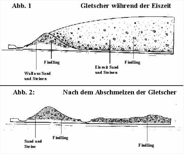
See the picture above: The wall of sand and stones is the end moraine

After the time of origin are distinguished young moraines (Weichselian, Würm) of old moraines (from the previous ice ages).

The term includes all moraine rubble that were carried and deposited by the ice. Moraines consist of material of different grain size from clay to sand to large boulders. But the material is mixed and has no sorting by size in the rule.

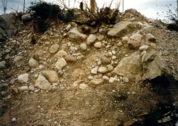
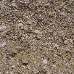
See the pictures above: examples for deposition material.

To the cache coordinates you are on the top of a glacial End moraine deposition.

From here you have a beautiful view over the countryside and the Schlei.

Look around a little and answered the following questions:

1 Is the original material of the moraine still visible?

2 What form of material was deposited here by the glacier?

3 Find out which of these glacial deposits derived.

4 Imagine you have stood on this site at that time:

Describes in own words how you envision the environment at the time - what would

you see, where would you stand on, for example?

After the response to our profile, or directly to teamchritho@go4more.de you can log immediately - if something is wrong we will contact you.

As usual with EC's we also look forward to great photos (but this is no loging condition!)

Sources:
Wikipedia

satgeo.zum.de

cms.fu-berlin.de

information panel

gidimap.giub.uni-bonn.de/

heimatverein.he-webpack.de/

www.Nordpaul.de


Erstellt mit gcffm Listing Generator

Additional Hints (No hints available.)