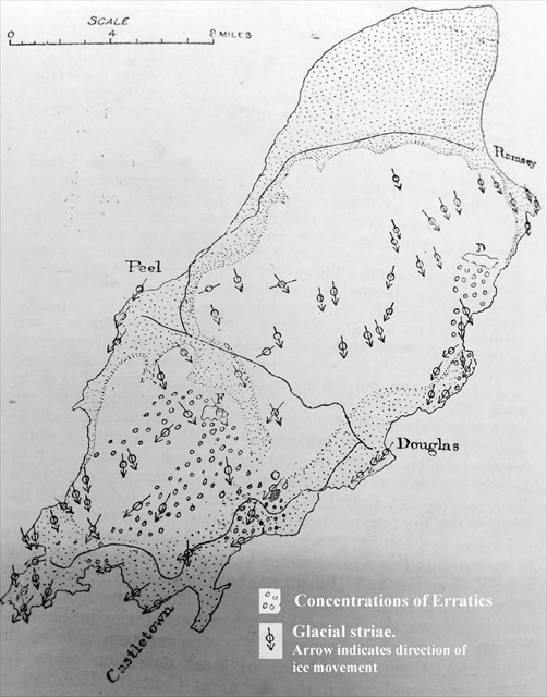
The position of the Isle of Man, near the centre of the northern Irish Sea, places it directly in the path of the great ice sheets which have, periodically, over the last 2.4 million years, advanced down that relatively shallow channel. The legacies of these ice sheets, both erosional and depositional, can be seen on the Manx landscape.*
Evidence for the ice being glacial rather than local can be seen on an outcrop of quartz rock at Slieau Menagh known as Creg Bedn, where there are striations that can only have been made by ice moving upwards.** There are striaitions made by moving ice visible in many locations island wide, including on surface slate within a few metres of Snaefell summit indicating that during the Ice Age the whole of the island, including the summit of Snaefell, was covered by the ice sheet.
When the glacial period ended in the Irish Sea basin about 12,000 years ago, it left behind boulders and other glacier-borne debris which had been carried within the icecap from lands to the North.**
Many of these large boulders can still be seen today and are known as "Erratics". A glacial erratic is a piece of rock that differs from the size and type of rock native to the area in which it rests. Lines of striation and analysis of the rocks show that these mainly came from Scotland. Indeed, evidence of riebeckite microgranite, which is unique to Ailsa Craig off the west coast of Scotland, has been found on many beaches on the island.
The ice also moved local rocks and boulders, including many of Foxdale granite, which crops out at 200 metres on the northern side of South Barrule. A significant number have been found 280 metres above this outcrop and even on the opposite side of South Barrule ridge and it was this phenomenon which convinced Charles Darwin of the glacial theory.
The co-ordinates on the page will take you to an erratic boulder mounted on a plinth in Onchan. To claim a 'find' for this Earthcache you must answer the following questions and send your answers in a message to the owner using the link at the top of the page. You can log your find as soon as you have sent your answers to the tasks. We will be in contact if there is a problem.
1. In which year was it placed in its present position?
2. Where was the likely origin of the boulder?
If you visit the Manx Museum (check the opening times), you will see an ice borne boulder of porphyritic greenstone mounted outside, between the two entrances (N 54° 09.273 W 004° 28.906). Little seems to be known about its origins as this type of rock is found on the Langness Peninsular but also the west coast of Scotland.
3. In which year was it uncovered in the drift above the Scarlett Limestone quarries?
4. Describe any differences you observe in shape, texture and colour between the two boulders.
* Source: Danny McCarroll - The Isle of Man - Celebrating a Sense of Place.
** Source: Mike Caine - Howstrake Prehistory