Sand dunes in Alaska? I know what you are thinking but sand dunes are not just for the hot climates of deserts they can also be found in cold climates as well and are a result of wind, glacial and river erosion. Sand dunes are a common geological feature in Alaska; they just look different than the desert sands you are thinking about when the word “sand dunes” is said. For about the first seven miles north along Taylor Highway from Tetlin Junction the road goes through a field of sand dunes. It is blown off the floodplains of the Tanana River and other rivers. In the summer time the winds still blow sand and silt off the river bars and barren glacial till.
Sand, gravel, silt and clay are all known as sediment, and come from the mechanical and chemical breakdown of rocks. Once it’s broken apart from the original source rock, this material is then eroded and transported by wind, water or ice, often ending up at the deposits of rivers. Eventually this material may be buried to sufficient depth within the earth to harden and form sedimentary rock. And thus the rock cycle starts again.

Source: http://trentolol.files.wordpress.com/2011/04/rock-cycle1.jpg
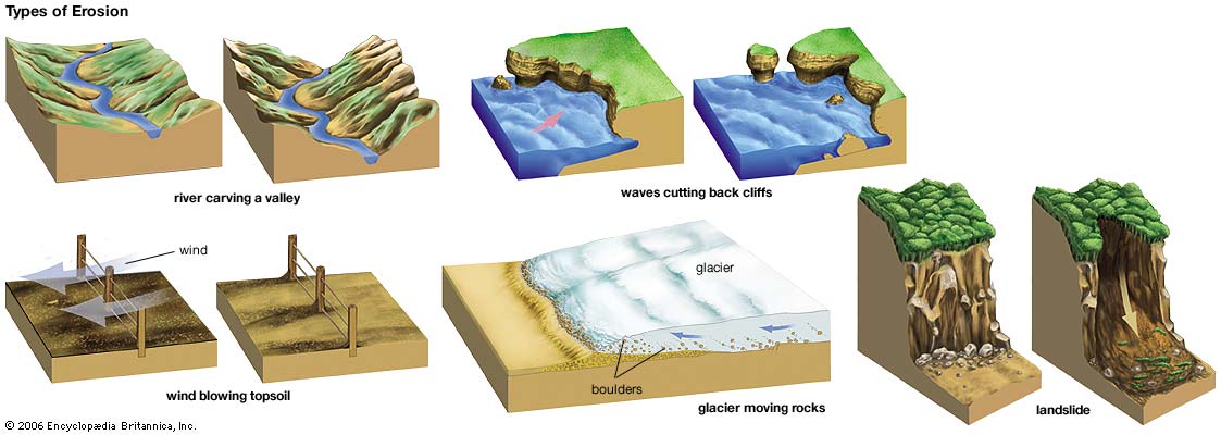
What is Erosion?
Erosion is the process by which soil and rock are removed from the Earth's surface by natural processes such as wind or water flow, and then transported and deposited in other locations. In this particular area at GZ, Water has caused most of the Erosion here.
Types of Erosion:
Splash Erosion: Small soil particles are detached and sent airborne through the impact of raindrops on soil.
Sheet Erosion: Raindrops break apart the soil structure and it's moved down-slope by water that flows overland as a sheet rather than definitive channels. This occurs frequently during cloud bursts.
Rill Erosion: This process develops small, short-lived, concentrated flow paths. These paths create a sediment source and delivery system for hill-slope erosion. Areas where precipitation rates exceed soil infiltration rates are more prone to this type of erosion.
Gully Erosion: Water flows in narrow channels during or directly following heavy rains or melting snow. The gullies can erode to considerable depths.
Valley or Stream Erosion: Continual water flow alongside land (along a linear feature) creates this type of erosion. It extends downward, deepening a valley, and head-ward, extending the valley into the hillside. This occurs most frequently in times of flooding.
Bank Erosion: Over time, banks of rivers and streams are naturally worn down.
Freezing and thawing: Cold weather causes water trapped in tiny rock cracks to freeze and expand, breaking the rock into several pieces.
Glaciers: erode predominantly by three different processes: abrasion/scouring, plucking, and ice thrusting. In an abrasion process, debris in the basal ice scrapes along the bed, polishing and gouging the underlying rocks, similar to sandpaper on wood. Glaciers can also cause pieces of bedrock to crack off in the process of plucking. In ice thrusting, the glacier freezes to its bed, then as it surges forward, it moves large sheets of frozen sediment at the base along with the glacier.
Source: (water)

**Logging requirements**
DO NOT POST ANSWERS IN YOUR LOG.
Send the following answers to me via email.
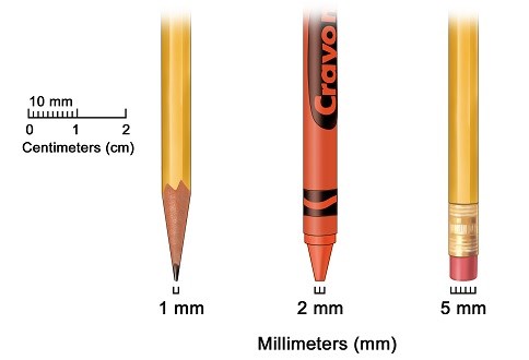
- The text "GC5D7JV Alaska Sand Dunes" on the first line
- What is the sand dunes color? (the majority color)
- What is the texture of the sand dunes?
- What are the sand particle size(s)?
- Count the number of sand dunes you can see from here?
- Name the primary source of erosion that moved this sand to here?
- Name the primary source of erosion that broke rocks down to this size of sand?
| I have earned GSA's highest level: |
 |
Sources
- Stuart N. Thomson, Mark T. Brandon, Jonathan H. Tomkin, Peter W. Reiners, Cristián Vásquez, Nathaniel J. Wilson. Glaciation as a destructive and constructive control on mountain building. Nature, 2010; 467 (7313): 313 DOI: 10.1038/nature09365
- Tomkin, J. H. & Roe, G. H. Climate and tectonic controls on glaciated critical-taper orogens. Earth Planet. Sci. Lett. 262, 385–397 (2007)
- Mitchell, S. G. & Montgomery, D. R. Influence of a glacial buzzsaw on the height and morphology of the Cascade Range in central Washington State, USA. Quat. Res. 65, 96–107 (2006)
- water: erosion. Art. Britannica Online for Kids. Web. 4 Sept. 2013. <http://kids.britannica.com/elementary/art-88797>