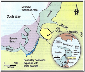
Davidson Cove Chert/Chalcedony Beds and Paleo Indian Site
Several locations of chalcedony beds were recorded in 1964 by geologists from the Nova Scotia Museum. Except for two areas with abundant chalcedony veins, these beds are generally thin and isolated. Nodules of chalcedony are also scattered on the beaches of most of the large coves. Most of the Coves are difficult to reach on foot due to high cliff faces, sometimes over 60 meters above the shoreline.
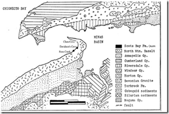
The source area along Scots Bay forms the Scots Bay Formation. It has several major outcrops of chalcedony. Two of these are easily reached on foot, while access to the other outcrops is limited by tidal activity. Water worn nodules of chalcedony are easily seen along the entire shoreline of this area and exposed chalcedony beds are common. Davidson Cove is one of these places.
The Scots Bay Formation
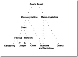
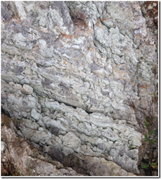
The lithic resources of Scots Bay and the Blomidon peninsula fall within the general class of sedimentary microcrystalline silicates commonly called chert. In both the geological and archaeological literature, the term chalcedony is more often applied to these deposits. Chalcedony is one of several subvarieties of chert distinguished on the basis of color, texture, internal structure and water content. According to geologist, John Thompson, the Scots Bay chalcedony is characterized by a structure of well defined polyhedral blocks, few or no water-filled cavities, and as colorless or light brown in transmitted light.
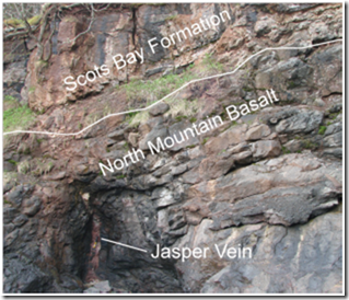
Davidson Cove is a site of geological archeological and historical values. Along the Bay of Fundy shore in the Scots Bay area, Davidson Cove has exposures of the late Triassic Age of Scots Bay formation. The late Triassic {200 million years ago} in Nova Scotia was marked by a period of great volcanic action along rifts zones created along faults that comprised the Cobequid-Chedabucto Fault Zone. This resulted in pushing the basaltic lava upward which is now forms the cap of the North Mountain. There was a warm climate that followed the volcanic action and a shallow lake was formed on top of the basalt. In this lake limestone, and sediment were deposited which eventually became known as the Scots Bay Formation. During early creation of this formation hot gases and silica rich fluids escaped from the underlying basaltic pile and permeated up into the sediments and replaced the lower most 2 or 3 meters of the limestone units and formed beds and cigar shaped nodules of chert, chalcedony, jasper and agate.
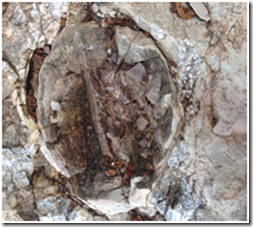
The first picture we took of a cigar shaped nodule of chert. N45 16.144 W064 24.708 we found at Davidson Cove
Despite appearance, all forms of chert have the same basic composition. It is a hard, brittle sedimentary rock composed of finely crystalline quartz and its chemical base is silica (SiO2). The presence of impurities give the stone colors other than white.
It was established by Professor M. Deal of Memorial University in 1988 that this geological area served as a major source of material for the first nations people. The materials found here were fashioned into tools and weapons following the lst ice age some 13000 years ago. To date some of the 4600 lithic artifacts have been unearthed and most originated in Davidson cove. Places like Bear River, Mersey River, Lake Rossignol, Weymouth ,and the Shubnacadie River System to name a few.
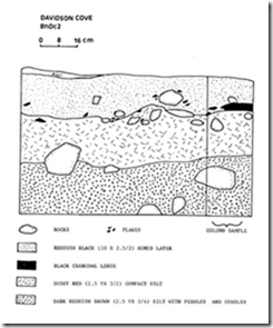
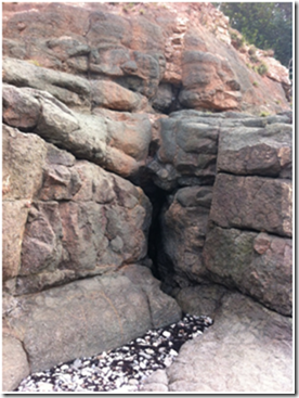
The Davidson Cove area consist of a section of Scots Bay Formation outcrop exposed along about 150 m of shore cliff and, adjacent to that , a workshop area. In the workshop the Mi’kmaw had set up their camp adjacent to the fresh water stream and took stone from the cliff exposures and worked them into tools and weapons. A considerable thickness of offcut chips and flakes from the long ago working of the stones is to be found as a layer now buried below the workshop area but exposed along the sides of the stream where it empties into the bay. It is the stone’s hardness and the way it breaks that made it invaluable to the Indians. They used chert to make arrowheads scrapping and cutting tools because it breaks with a curved or shell like fracture, leaving the edges as sharp as glass.
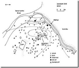
The beds of chert and chalcedony in the cliffs themselves show obvious evidence of past digging. A couple of cave-like indentations are to be found on the chert beds as well as a reddish-brown vein of jasper. As well, high on the bank near the western end of the exposure is found what looks like to be the remnants of a small quarry on a section of chert containing several cigar-shaped chalcedony nodules. However, it is impossible to know just how much of the digging was done by Mi’kmaw and how much by mineral collectors.
click here A guide to rock and mineral collecting in Nova Scotia.
click here Tide times for Bay of Fundy
This new brochure explains the rules and regulations for collecting rocks, for the hobbyist, and one can remove only what a collector can reasonably carry. http://novascotia.ca/natr/meb/data/pubs/ic/ic66.pdf
"Nova Scotia regulations state that collecting must be done for personal interest, recreation, or pleasure. Samples are obtained using hand tools only, with no ground disturbance. The amount of material removed from a specific site must not exceed what would be considered easy to carry unassisted by a collector. Collecting at a specific site or location is restricted to one day per year. No collecting is to be carried out for any commercial purposes outside the province. The Province of Nova Scotia generally encourages the pursuit of rock and mineral specimens as long as collectors follow certain policies and guidelines.”
Please follow these guidelines when collecting on the beachs."Leave No Trace".
To claim this geocache: Do not post answers with log but email to Cache owner. Thank you.
1. Seach the beach for some interesting rock samples and email your description of the sample and your guess as to what it might be? Post a picture of your finds if so desire.
2. Locate the cigar shaped nodule of chert. N45 16.144 W064 24.708 and describe what it looks like, the color and measure its diameter.
3. What color is the basalt and what type of rock is it? Igneous,sedimentary, metamorphic?
4. Why do you think the rocks in this area are the most exposed of all basins on the planet?
- Post a picture of at the site
5[REQUIRED] In accordance with the updated guidelines from Geocaching Headquarters published in June 2019, photos are now an acceptable logging requirement and WILL BE REQUIRED TO LOG THIS CACHE. Please provide a photo of yourself or a personal item in the picture to prove you visited the site.
Davidson Cove area can be assessed by the beach. If you want a 2 1/2 km walk on the beach park at Scots Bay and walk the basalt covered beach towards the south . Also parking is available on the Old Huntley Road on the way to Scots Bay where there is a walkway to the beach and would be about a 1 km walk on the beach. Always be cautious of the tides when walking the beaches.