This Earthcache takes you to the overlook at the Falls of the Ohio Interpretive Center. The view from here is actually the tailwater of the Cannelton Dam, some 120 miles down river. But the floodplain here is affected primarily by the flow controlled by the McAlpine Dam.
Floodplains
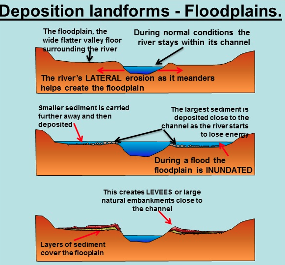
A floodplain is the flat land beside a waterway that floods due to precipitation, meltwater, or a pool elevation increase controlled by a downstream dam. When the floodplain is covered with water, the stream deposits sediment across the plain. If you show up at this park after a flood event, you can often see sand and mud and debris on the paved paths and boardwalks. Use caution.
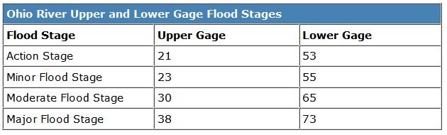
For the upper McAlpine Dam pool, normal pool gage is 12 feet. Ohio River flooding typically occurs between January and May, can last for days or weeks, and is generally predictable. The lower pool pictured above can be as low as nine feet in the dry fall months and upwards of 55 feet in January thru May. The highest recorded reading was 85.4 feet at the crest of the 1937 flood.
Clast
A clast is a fragment of geological detritus, chunks and smaller grains of rock broken off other rocks by physical weathering. Geologists use the term clastic with reference to sedimentary rocks as well as to particles in sediment transport whether in suspension or as bed load, and in sediment deposits.
Speed
Water speed (velocity) has everything to do with the size of clasts you will see below you. Simply put: the faster the water, the bigger the clast. It takes very swift water to move boulder-sized clasts, so if the water isn’t fast enough, it flows around boulders, which stay in place. Some streams flow so slowly that they can move clasts only as large as grains of sand.
 Fast moving water has enough energy to carry a large amount of materials, known as the stream's load. Raging floodwaters can pick up all sizes of particles, debris and huge boulders until they no longer have the energy to move them.
When the stream water level rises, it may overflow its banks, spreading out into adjacent areas. The water then slows quickly and drops heavier particles and debris it has been carrying. This leaves a higher bank along the stream's floodplain, known as a natural levee. As the water spreads farther from the channel and slows even more, it drops its sediment load, adding silt and sand to the soils present there.
Flooding is a natural and expected aspect of the life of a stream. For this reason, many communities have zoning ordinances regarding building on floodplains. To think that we can stop flooding is naïve. With engineering technology we may be able to exert limited control over it and minimize the damage, but nature has the last word. .
At the waypoint, you’ll be standing on a boardwalk overlooking the typical floodplain. Information is all around you. To demonstrate the educational value of this earthcache and earn credit, email answers to the following questions via my profile. Do not put them in your log.
1. What is the present lower gage reading, (502 775-5056)?
Fast moving water has enough energy to carry a large amount of materials, known as the stream's load. Raging floodwaters can pick up all sizes of particles, debris and huge boulders until they no longer have the energy to move them.
When the stream water level rises, it may overflow its banks, spreading out into adjacent areas. The water then slows quickly and drops heavier particles and debris it has been carrying. This leaves a higher bank along the stream's floodplain, known as a natural levee. As the water spreads farther from the channel and slows even more, it drops its sediment load, adding silt and sand to the soils present there.
Flooding is a natural and expected aspect of the life of a stream. For this reason, many communities have zoning ordinances regarding building on floodplains. To think that we can stop flooding is naïve. With engineering technology we may be able to exert limited control over it and minimize the damage, but nature has the last word. .
At the waypoint, you’ll be standing on a boardwalk overlooking the typical floodplain. Information is all around you. To demonstrate the educational value of this earthcache and earn credit, email answers to the following questions via my profile. Do not put them in your log.
1. What is the present lower gage reading, (502 775-5056)?
2. What comprises the 'natural levy' or debris line above the present pool?
3. What is the largest clast you see from this location (binoculars may help).
4. On the building behind you the highest band of YELLOW brick represents the high water mark of the 1937 flood. How far over -your- head would that water be?
5. Observation: How far north could the 1937 floodwaters reach today? Why?
6. Using information nearby, explain the degree of flood control provided by the McAlpine Dam.