Definition: Geomorphology
Geomorphology is the scientific study of landforms and the processes that shape them. (Wikipedia)
Definition: Fluvial
Fluvial is a term used in geography and geology to refer to the processes associated with rivers and streams and the deposits and landforms created by them. (Wikipedia)
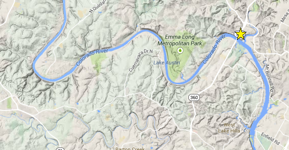
The particular landform that we can observe here is called the “Meander”.
Definition: Meander
A meander, in general, is a bend in a sinuous watercourse or river. A meander forms when moving water in a stream erodes the outer banks and widens its valley, and the inner part of the river has less energy and deposits silt. (Wikipedia)
So meanders are the results of the combination of lateral erosion and deposition.

Lateral Erosion: Typically, the water flows faster on the outside of the bend, and the extra energy erodes the outside bank, called a “cut bank” or river-cut cliff. (see B and C’ in the figure above)
Deposition: The water on the inside bank has a slower flow and thus can typically deposit materials in what is called a “point bar”. (see B’ and C in the figure above) This causes the inside bank, over time, to have a gentle slope referred to as the “slip-off slope”.
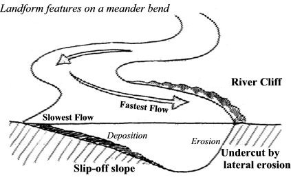
As more material is taken from cut banks and deposited into the point bars, the velocity differential increases, and the effect is even greater.
Overtime, meanders expand and become larger until they meet. Old meanders are then abandoned and become what is called an oxbow lake. (See Figure below)

Earthcache questions:
Now that you have learned about meanders, let’s put it in practice.
- Looking at highway 360 on the south (far) side of the bridge, how would you describe the type of slope that you see?
- Based on the earthcache description, what is the geological term for it and what is it typical of?
- Looking at the natural bank on the side of the overlook, how would you describe the type of slope?
- Based on the earthcache description, what is the geological term for the area of the overlook?
- A long time ago, before the meander was so pronounced, where do you think the bed of the Colorado River used to be?
- Bonus question: Looking at the layers of rock (strata) exposed across 360 from the overlook (same side of bridge), do you think that any type of uplift had an influence on the course of the river?
- Optionally, post a picture from the overlook.
To validate your visit, please send me your answers by message preferably and attach the optional pictures to your log.
References