The exposed bedrock at Portland Head belongs to the Cushing Formation, which is named for Cushing Island. The Cushing Formation underlies an area that stretches northeasterly across Casco Bay from the Delano Park area through Cushing Island, Peaks Island, Long Island, Chebeague Island, the Goose Islands and Birch Island to the Brunswick shore. The Cushing Formation is more resistant to weathering which is why it forms such prominent rocky headlands and islands. A close look at the rocks at Portland Head reveal clues to the long geologic history. The Cushing Formation was produced through volcanic activity approximately 470 million years ago. During this time the rocks were heated, liquefied, compressed, and twisted, causing the rocks to be stretched and deformed. This deformation produced the lineation of the minerals that characterizes the Cushing formation. The rock is broken along a series of straight, parallel fractures that are oriented east-west and vertical.
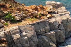
Standing at the given coordinates you have an excellent view of a Basalt dike. Basalt is a volcanic rock that is dark in color, low in silica, and rich in iron and magnesium. The basalt is formed when molten rock intrudes along a vertical fracture in the surrounding rock, solidifies underground and forms a thin sheet of rock known as a dike. Please answer the following questions at this location:
- Were you here at high or low tide…or sometime in between?
- Can you see the basalt? (hint: look in the space between the headland and the small 'island')
- Where did it go?
- Why can you still see the rest of the headland?
At the second set of coordinates you will see a different kind of rock intrusion. These are veins of quartz. These veins form because minerals have different melting points. When there is molten rock that begins to cool, the molten quartz has a lower melting point and seeps into the cooling rock and solidifies as a vein in the middle of the rock.

Please answer the following questions at this location:
5. What does the quartz look like up close? Do you see shiny flecks? What do you think these flecks are and how did they get there?
6. Do you think the quartz is harder or softer than the basalt? Do you think it is harder or softer than the surrounding rock? Why?
Thank you for visiting this Earth Cache. Please send me an email (address can be found in my profile) with the answers to these questions when you post your 'found it'. Please put "Cushing Formation" in the subject. Please feel free to post a photo of your visit to this Earth Cache we would all love to see it.
Congratulations!! FTF goes to marcipanek