HISTORY OF VENDOME WELL
Vendome Well is the largest artesian well in the state of Oklahoma, tapping deep into the Arbuckle-Simpson aquifer. The mineral waters that feed the wells and springs in the area were first discovered by the native people of the southern plains, who believed the waters had healing qualities.
By the late 1890s, settlers had built the town of Sulphur Springs, complete with hotels, resorts, and bath houses that promoted the medicinal qualities of the water. In 1902, the Chickasaw and Choctaw tribes sold 700 acres of their land to the United States, under the condition that the springs would be preserved. The land was then designated as Platt National Park in 1906, as a tribute to United States Senator Orville H. Platt. The park later merged with the nearby Arbuckle Recreation Area to become Chickasaw National Recreation Area.
Not all the land was park land, however. Originally, Vendome Well was drilled just eight feet outside of what was then park land, and it was a gusher: the water flowed at between 2,500 and 3,500 gallons per minute, creating a tall fountain. A pool was built around it, and a combination bath house and dance hall was a popular attraction.
In 1935, the Vendome stream, previously a ditch, was redesigned by the Civilian Conservation Corps to create “the most distinctive attraction of the area,” an “artificial creek” with two wading pools located along its length. The stream was given a new, more meandering course through the park and emptied into Travertine Creek, where it created a waterfall.
In 1979, the National Park Service acquired the Vendome Well property. In 1998, Vendome Well was completely overhauled following the drilling of a new well about twenty feet west of the original well enclosure. The new well had a stainless steel casing to resist corrosion, and the water was piped to the center of the historic concrete enclosure. The well today flows at a much lower rate than the old well, about 500 gallons per minute.
GEOLOGY OF THE PARK
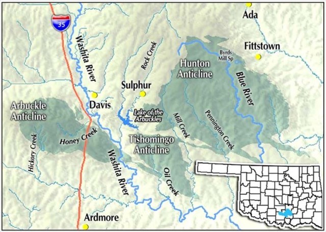
The park is located in an uplifted area commonly referred to as the Arbuckle Mountains, which is characterized by great thicknesses of mostly carbonate rocks, uplifts, folded structures, and large fault displacements. Once higher than the Rocky Mountains, the Arbuckle Mountains—which surround the Platt District on the south, east and west—have eroded over the years. Soil deposits from this erosion have defined the geologic conditions of lower elevations. The springs and wells in and around the park are a part of the Arbuckle-Simpson aquifer, an aquifer system that underlies more than 500 square miles in south-central Oklahoma. The aquifer is the principal water source for Sulphur, Ada, and the surrounding area.
The Arbuckle Group, which based on current scientific theory is about 500 million years old, consists of faulted and folded dolomitic limestone and some sandstone, up to 4,000 feet thick in some areas. Geologists believe the Simpson Group is younger, about 450 million years old, and consists of limestone, sandstone, and some shales, up to 1,600 feet thick. Both groups of rocks are primarily made of the same basic mineral, calcium carbonate, which came from the shells of sea life that lived here back when this area was submerged under an inland sea. See Figure 1 for a map of the aquifer:
WATER FROM THE WELL
For any given aquifer, the fresh water is underlain either by rock that is not very permeable, and therefore does not produce much water, or by saline water, that is, water that contains more than 10 grams per liter of dissolved solids. It's not known how deep the Arbuckle-Simpson aquifer is. Most wells are only drilled until they reach fresh water, perhaps 200 feet. A test well drilled during a 2009 study of the Arbuckle-Simpson aquifer was drilled to 1,820 feet and still found only fresh water.
Vendome Well produces water that comes all the way up from the boundary of the freshwater and saline water zones. Studies show that the water from the well is a mix of about 99% water from the freshwater zone and 1% brine from the saline water zone. The 1% brine component is likely why the water contains concentrations of several trace elements (potassium, fluoride, bromide, iodide, ammonia, arsenic, boron, lithium, selenium, and strontium).
OLD, DEEP WATER
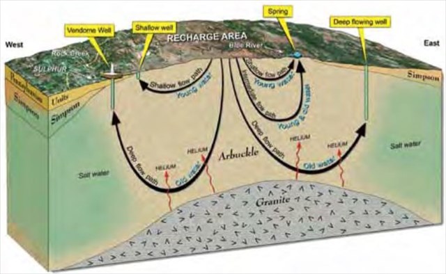
The water you see flowing from Vendome Well has been underground for over 10,000 years! A study confirmed this by analyzing the water for tritium, helium-3, and carbon-14.
Tritium is a radioactive element, some of which is naturally formed in the atmosphere and some of which was produced by nuclear tests. Tritium combines with water molecules in the atmosphere. Tritium has a half-life of 12.32 years, meaning that half of a given sample of tritium would decay into helium-3 in that time, and after about 60 years, so little tritium is left that it is immeasurable. Most of the other water samples collected as part of the Arbuckle-Simpson Hydrology Study contained some tritium, meaning the water was in the atmosphere within the last 60 years. No tritium was found in Vendome Well water, so scientists turned to carbon-14.
Carbon-14 is another radioactive isotope present in the atmosphere, but it has a much longer half-life than tritium, about 5,730 years. Using carbon-14 dating, the study concluded that the Vendome Well water has been underground for about 10,500 years. This old water indicates that the water that discharges at the well flows along long flow paths deep in the aquifer, whereas younger water flows along shorter flow paths at shallower depths.
See figure 2 for an illustration of the difference between Vendome Well and the freshwater springs:
The water here contains more than just helium-3 and carbon-14. As you look at the water, you may see a film on the bottom of the pool and spillway, even on some of the plants in the water. When water comes out of the ground, the change in pressure, as well as the change in temperature, can cause minerals dissolved in the water to precipitate.
LOGGING THIS EARTHCACHE:
To log this earthcache, email us or send us a message and copy and paste these questions, along with your answers. Please do not post the answers in your log, even if encrypted. There's no need to wait for confirmation from us before you log, but we will email you back if you include your email address in the message. Group answers are fine; just let us know who was with you.
1. The name of this earthcache: Vendome Well Earthcache.(skip this if you're sending a message)
2. Observe the pool and the fountain. How is the water flow today? Is the pool clear or cloudy? Do you see any evidence of materials having precipitated out of the water, like deposits on the pipe or the bottom of the pool?
3. Smell the water.
a. What do you smell?
b. (Optional) Taste some of the water using one of the spigots. Does it taste like it smells?
4. In your own words, how long has the water flowing from the well been underground, and how did scientists determine that?
5. Post a photo of you, or your phone or GPSr or a personal item, with the fountain in the background. (You can simply include this in your message if you do not wish to post this in your log.)
SOURCES
Christenson, Scott, Hunt, A.G., Parkhurst, D.L., and Osborn, N.I., 2009, Geochemistry of the Arbuckle-Simpson aquifer: U.S. Geological Survey Fact Sheet 2009–3013.
Christenson, Scott, Osborn, N.I., Neel, C.R., Faith, J.R., Blome, C.D., Puckette, James, and Pantea, M.P., 2011, Hydrogeology and simulation of groundwater flow in the Arbuckle-Simpson aquifer, south-central Oklahoma: U.S. Geological Survey Scientific Investigations Report 2011–5029.
Heidi Hohmann and Katarzyna Grala, "Cultural Landscape Report—Platt Historic District." National Park Service, 2004.
U.S. National Park Service, "List of Classified Structures: Vendome Well." (no longer available online)
U.S. National Park Service, Nature and Science: Vendome Well
Graphics: Oklahoma Water Resources Board fact sheet, newsletter
U.S. Geological Survey, "Hydrogeology of the Chickasaw National Recreation Area, Murray County, Oklahoma."
This earthcache was placed with the permission of the National Park Service.