While it lacks the usual shape, the Dead River is labeled an oxbow. It is a body of still water beside a river and it appears to have been disconnected from the Vermillion at some point in the past. In this EarthCache, you will be asked to observe its present characteristics and to think about how the Dead River came to be an oxbow.
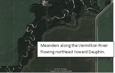
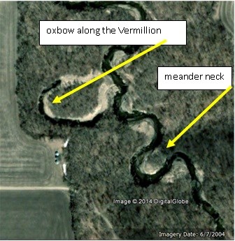
Oxbow lakes are formed by a change in the channel of a meandering river. The channel of a river that meanders, loops side to side as the river flows forward. Each loop along the river is called a meander. The Vermillion River, shown in the satellite photos, is an example of a meandering river.
The current of the river causes sediment to be removed from the outer edge of each curve along its channel. This erosion causes the neck of a meander to narrow over time. Eventually, the river finds its way across the shorter path of the neck and the loop is cut off from the river. The body of water formed in this way almost always has a "U" shape or crescent shape.
Occasionally oxbows are manmade. A desire to shorten the course of a river or to drain and farm the land occupied by meanders can motivate the decision to cut a new channel for a river.
The posted coordinates take you to a place in Vermillion Park near the southeast end of the oxbow and about 285 meters from the river. Observe the shape and size of the water channel, where does it end and how full of water it is at the time you are there. Observe any manmade structures that may affect the oxbow or be affected by it.
Follow the walkway to the northwest end of the oxbow. Again, observe all relevant natural and manmade elements of the area. Use your GPSr to estimate the distance between the river and this end of the oxbow.
This is an EarthCache. To get credit for a find you must submit the following requested information to the cache owner.
1) Briefly summarize your observations of the southeast end of the oxbow noting at least one natural and one manmade feature. Comment on the water level at the time you are there.
2) Describe one manmade feature at the northwest end of the oxbow.
3) Compare the distances between the river and each end of the oxbow.
4) Tell whether you think this oxbow lake occurred naturally or was created by human intervention and say why you think so.
Resources
Dauphin Recreation Services
http://www.dauphinrec.com/facilities/vermillion-park-campground
What is an Oxbow Lake?
http://www.mbgnet.net/fresh/lakes/oxbow.htm
The Phenomenon of Natural and Artificial Oxbow Lakes
http://geography.answers.com/natural-features/the-phenomenon-of-natural-and-artificial-oxbow-lakes
| I am a proud |
 |
