
Local geology:
Sand Prairie Conservation Area is a 200-acre upland area located in Scott County near Benton, Missouri. The quartz crystal sand grains that make up this area is part of the sandy surface of the Blodgett terrace alluvium and covered by closely spaced network of braided stream channels. This natural area has small dune-like hills stabilized by vegetation subtly gradate into expansive flats. The surrounding landscape speaks of the early Holocene winds and braided waters of glacial outwash that are responsible for the sandy accumulation.
Here you can see the faint outlines of old river beds.

A Physiographic Region is a region of which all parts are similar in geologic structure and climate and which has consequently had a unified geomorphic history; a region whose patterns of relief features or landforms differs significantly from that of adjacent regions. The Mississippi Embayment is a physiographic feature in the south-central United States, part of the Mississippi Alluvial Plain. It is essentially a northward continuation of the fluvial sediments of the Mississippi River Delta to its confluence with the Ohio River at Cairo, Illinois. The embayment is a topographically low-lying basin that is filled with Cretaceous to recent sediments.
What is Erosion?
Erosion is the process by which soil and rock are removed from the Earth's surface by natural processes such as wind or water flow, and then transported and deposited in other locations.
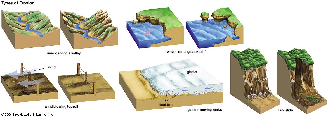
Types of Erosion:
Splash Erosion: Small soil particles are detached and sent airborne through the impact of raindrops on soil.
Sheet Erosion: Raindrops break apart the soil structure and it's moved down-slope by water that flows overland as a sheet rather than definitive channels. This occurs frequently during cloud bursts.
Rill Erosion: This process develops small, short-lived, concentrated flow paths. These paths create a sediment source and delivery system for hill-slope erosion. Areas where precipitation rates exceed soil infiltration rates are more prone to this type of erosion.
Gully Erosion: Water flows in narrow channels during or directly following heavy rains or melting snow. The gullies can erode to considerable depths.
Valley or Stream Erosion: Continual water flow alongside land (along a linear feature) creates this type of erosion. It extends downward, deepening a valley, and head-ward, extending the valley into the hillside. This occurs most frequently in times of flooding.
Bank Erosion: Over time, banks of rivers and streams are naturally worn down.
Freezing and thawing: Cold weather causes water trapped in tiny rock cracks to freeze and expand, breaking the rock into several pieces.
Glaciers: erode predominantly by three different processes: abrasion/scouring, plucking, and ice thrusting. In an abrasion process, debris in the basal ice scrapes along the bed, polishing and gouging the underlying rocks, similar to sandpaper on wood. Glaciers can also cause pieces of bedrock to crack off in the process of plucking. In ice thrusting, the glacier freezes to its bed, then as it surges forward, it moves large sheets of frozen sediment at the base along with the glacier.
Wind erosion is a major geomorphological force, especially in arid and semi-arid regions. Wind erosion is of two primary varieties: deflation, where the wind picks up and carries away loose particles; and abrasion, where surfaces are worn down as they are struck by airborne particles carried by wind.
Mass movement is the downward and outward movement of rock and sediments on a sloped surface, mainly due to the force of gravity. Mass movement is an important part of the erosional process, and is often the first stage in the breakdown and transport of weathered materials in mountainous areas. It moves material from higher elevations to lower elevations where other eroding agents such as streams and glaciers can then pick up the material and move it to even lower elevations. Mass-movement processes are always occurring continuously on all slopes; some mass-movement processes act very slowly; others occur very suddenly, often with disastrous results.
Source: (water)
Alluvium: material deposited by rivers. It is usually most extensively developed in the lower part of the course of a river, forming floodplains and deltas, but may be deposited at any point where the river overflows its banks
Terrace: In geology, a terrace is a step-like landform. A terrace consists of a flat or gently sloping geomorphic surface, called a tread, that is typically bounded one side by a steeper ascending slope, which is called a "riser" or "scarp." The tread and the steeper descending slope (riser or scarp) together constitute the terrace.
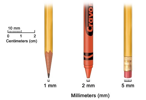
Sand particle information

**Logging requirements**
DO NOT POST ANSWERS IN YOUR LOG.
Send the following answers to me via email.
- The text "GC5FB03 Sand Prairie CA" on the first line
Using a black piece of paper take a small pinch of sand
and place it on the paper to answer the following 2 questions
- What is the size of the individual sand partials?
- What colors are the sand?
- What’s the elevation here?
- Measure the sand dune area here? (Width and length)
- What is the GPS coordinates of the tallest sand dune between the areas outlined on the photo below?

| I have earned GSA's highest level: |
 |
Sources