Scientists define an ice age as an extended period of time (millions to tens of millions of years) when the average global temperature is colder and large areas of the Earth are covered by continental ice sheets and alpine glaciers. An ice age can also contain multiple shorter-term periods of warmer average temperatures. During these periods, the glacial face melts at a rate faster than the ice is flowing from the origin and the net effect is a glacial retreat.
Scientists have found evidence of five major ice ages. The earliest started over 2 billion years ago, and the most recent one, the Quaternary Ice Age, began approximately 3 million years ago and continues today. The last glacial episode that affected New York State is popularly known as the Ice Age. Scientists consider this "ice age" to be merely the latest glaciation period in the Quaternary Ice Age. Currently we are in a warm interglacial period that began about 11,000 years ago.

Several theories have been proposed to explain the climatic changes that initiate an ice age, including catastrophic events and changes in ocean and atmosphere circulation patterns due to the Earth’s ever-moving continents. One theory suggests a period of increased volcanic activity that produced a dense cloud of volcanic ash that filtered the energy from the sun. The start of the Quaternary Ice Age is attributed to continental plate-tectonic movement that created the land bridge between the continents of North and South America and blocked warm water flow from the equator to the poles.
The advancing and retreating glacial periods within the current ice age have been attributed to the cyclic changes in the Earth’s orbit, which affects the amount of sunlight reaching different parts of Earth’s surface. The warmer interglacial periods have lasted between 10,000 and 30,000 years.
Glaciation was a dynamic process in Western New York and many examples of glacial geomorphology can be observed. The Great Lakes were scoured by the glacier and Niagara Falls resulted from the melt waters. Drumlin, esker, kame, moraine and kettle landforms were created by glacial action.
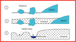
When temperatures at the leading edge of the glacier began to increase, the edge of the ice sheet gradually melted and the ice front retreated northward. Melt water from the glacier was blocked by the higher elevations to the South and glacial lakes developed in front of the glacial face. Massive chunks of ice, similar to icebergs, detached from the edge of the glacier and fell into the glacial lake. These chucks of ice were buried by sediments that were being released from the melting glacial face. When the chucks of ice did melt, a void was left behind that subsided and created a kettle hole. Kettle holes are usually circular in shape and can be filled with water, sediment, or vegetation.
Beaver Meadow Audubon Center is known for its namesake beaver pond and also has several examples of glacial kettle ponds. Park in the lot at the Visitor Center and proceed across Welch Road to the trailhead for the Kettle Pond Trail. The listed coordinates will bring you to a foot bridge in the center of a kettle pond. The foot bridge and trail are on a low dike that bisects the kettle and divides it into two sections.
To claim credit for this EarthCache, please answer the following questions. Do not post your answers in the log. You do not need to wait for a confirmation of your answers before logging your visit.
1. In your own words, what is the primary factor in the creation of a kettle? What determines the size of a kettle?
2. The last glacial advance to affect Western New York is commonly called the Ice Age. Why is this name technically incorrect?
3. When do you predict the next period of glaciation will begin?
4. At the listed coordinates, describe the topography around you. List some similarities and differences that you observe between the two sections of the kettle.
5. What is the source of the surface water in the kettle?
6. (Optional for extra credit) How was the dike that bisects the kettle created?
Beaver Meadow is a 324-acre nature preserve in North Java, NY. The preserve also features wetlands with a boardwalk trail, wooded uplands, meadows, a hawk watch, an arboretum, and eight miles of marked and groomed trails. Presently, there are 14 active geocaches on the property.
The Audubon Society has requested that you stay on the marked trails and do not disturb any natural habitats. Dogs are not allowed on any of the trails. We wish to thank Mark Carra for his assistance and the Buffalo Audubon Society for granting permission to establish this EarthCache.
Resources;
Dynamical Paleoclimatology: Generalized Theory of Global Climate Change, 2002, Barry Saltzman
Evidence for Warmer Interglacials in East Antarctic Ice Cores, 2009, L.C. Sime
Glacial Geology of Western New York, 1897, Fairchild
Strand Lines and Chronology of the Glacial Great Lakes in Northwestern New York, 1970, P E Calkin
Latest Pleistocene and Holocene Sediment Records from Wetlands in Western New York, Cassandra Osterhoudt
Congrats to GO Geiger, the first to visit and answer the optional question.