Cheniers are relict Holocene beach ridges trending east-west that are formed by wave action, offshore currents, and the influence of the Mississippi River. They are separated by intervening mud-flat deposits with marsh and swamp vegetation. Additionally, cheniers are typically 1 to 6 m high, tens of km long, hundreds of meters wide, and often wooded as the name implies.
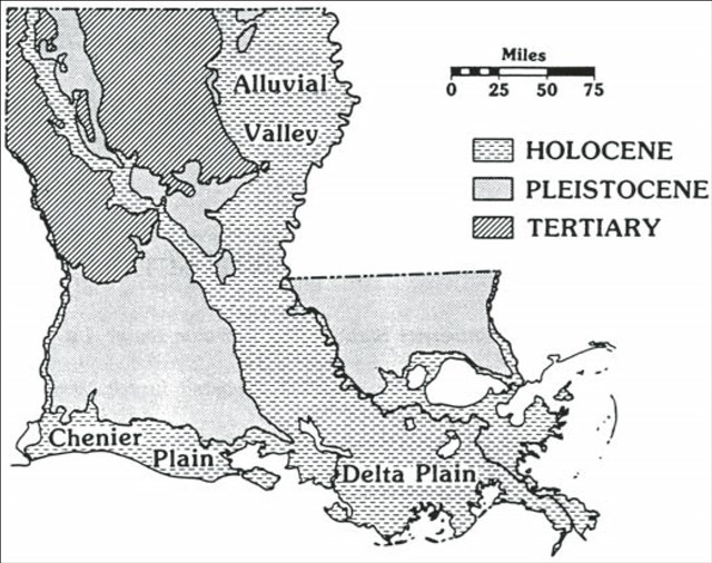
Geologic map of Louisiana locating Chenier Plain. from Fisk Penland and Suter (1989, Fig. 1).
Coastal Louisiana is basically divided into two large regions – the deltaic plain in the east and chenier plain in the west, with Vermilion Bay acting as the dividing line. The deltaic plain consists of deposition from rivers such as the Mississippi and Atchafalaya. The chenier plain has no large sediment sources and relied on washing upon of sand and/or mud from storms in the gulf. Henry Van Wagenen Howe, a LSU geologist and perhaps the premier micropaleontogical academian of his time in the Gulf Coast first suggested the formation of the chenier plain in 1935. He surmised that they are a result of shifting delta lobes of the Mississippi River. When the lobes were closer the area received mud deposits, however, when the lobes were more distant waves deposited the sand that formed the cheniers

Landforms of the Calcasieu headland area. from Penland and Suter (1989, their Fig. 12).
The chenier soil is classified as Hackberry loamy fine sand (Hb) a somewhat poorly drained, rapidly permeable soil found in sandy and loamy beach deposits. While the soil occupying most of the area north of the highway is classified as Creole mucky clay (CR) a very poorly drained, very slowly permeable, moderately saline soil in brackish marsh. Because of their higher elevation these cheniers became locations of communities and the roads that joined them together. Cheniers are also extremely important to migrating birds especially since Louisiana lies in the center of the flight path of birds crossing the Gulf of Mexico. As many as two million birds use a nearby sanctuary each year. There are three locations to look at for this earth cache. The northernmost is on a chenier at the initial location on the north side of the Gulf Coast Highway 82, the second is in a swale along Parish Road 532 (N 29o 45.328’; W 093o 39.826’) and the southernmost is on the beach (N 29o 44.921’;W 093o 39.843’) (Owen, D.E. 2008. Geology of the Chenier Plain of Cameron Parish, southwestern Louisiana, in Moore, G., ed., Geological Society of America Field Guide 14, 2008 Joint Meeting, Houston, Texas, 5-9 October 2008, p. 27-38) (http://www.braudubon.org/peveto-woods-sanctuary.php) (Soil Survey of Cameron Parish, Louisiana. 1995. USDA-SCS)
To qualify for this cache answer the following questions: 1. How are cheniers formed? 2. Why are they important to people and wildlife? 3. Determine the elevations at the three locations. 4. Look at the soil at each of the three locations. Describe how they fit into the process of how cheniers are formed.