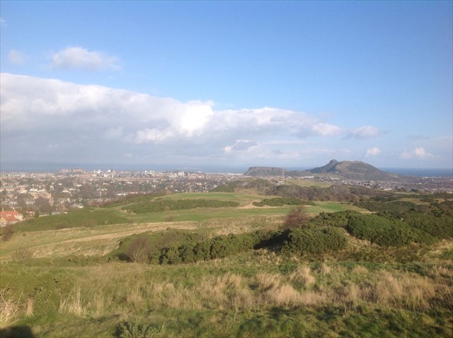
Scotland is divided into three distinct geological parts by two great faults: the Highlands; the Midland Valley (or Central Lowlands); and the Southern Uplands. The Midland Valley is bounded by the Highland Boundary Fault and the Southern Upland Fault. You are standing at an information disc at the summit of the Braid Hills, one of the Seven Hills of Edinburgh. This disc was originally installed in 1995 but was missing for several years before being replaced on 1st November 2014. From the disc you will, weather permitting, enjoy a fabulous panoramic view of the City of Edinburgh and you can see all 7 of the hills, and further over the Firth of Forth to Fife and beyond. On a clear day you can see the turrets of the Forth Bridges, and I like to watch aeroplanes on their final approach to the airport.
Take a while to learn more about how our country was made. The Midland Valley’s oldest rocks date from the Ordovician period, about 470 million years ago. The area that was destined to become the Midland Valley was originally a string of volcanic islands that collided together in a collision called the ‘Caledonian Orogeny’. Given our usual weather, it’s hard to believe that Scotland once lay south of the equator! (you can find evidence of this at another fine earth cache, some 20 miles West of here, ‘Tropical Bathgate’ GC4X6VY.) Without a doubt, Scotland was indeed a land of Ice and Fire, with violent volcanic eruptions and sculpting of the hills and valleys by glaciation forming our land of today. Midland Valley is now largely made up of Paleozoic formations which furnished the area with the coal and iron that until very recently was so important to the industry of Scotland. I remember very clearly as a girl growing up in Motherwell, the sky turned red every Friday evening as the great blast furnaces were opened at the Ravenscraig steelworks, sadly no more. 300 million years ago, the whole area was very actively volcanic (Arthur’s seat is a great example) and also of glaciation. You are looking down into the Hermitage of Braid, which is a ‘dry valley’ formed by the glacial meltwater.
Once you’ve had your fill of the view, you can find most of the answers required to log this earth cache right here on the information disc. To log the cache, send me your answers to the following questions: do just go ahead and log it, I’ll contact you if there are any errors.. And do please post lots of photos! (optional).
1.What is the plinth made of, and where did it come from?
2.Name the 7 Hills, their height, and distance from the information disc
3.Can you see Edinburgh Castle? It’s very nearly due North of here. You can if the weather is good! What is the term given to the classic geological feature demonstrated by the Castle Rock and its esplanade?
4.The best preserved volcano is, of course, Arthur’s Seat. What are the 2 features that mark the central pipe or ‘vent’ of the volcano?
5. Have a look around at the shape of the hill and surrounding land here. In your own words: write a few sentences to describe when and how the Braid Hills were formed?
I hope you learnt as much as I did.
Don’t forget while you’re here: you can find one of the clues for the 7 Hills of Edinburgh multi cache (GC5ACW6) and find a traditional cache very nearby, aptly named ‘Capital 360’ (GC3CHQ6)
Parking: on Braid Road opposite the entrance to the bridle path at N55º54.748 W003º12.618 At time of writing, there is unrestricted parking at the roadside here.
Terrain: The CO can get to the cache from the car in less than 10 minutes…but this is no ‘cache and dash’: there is a well marked bridle path, quite steep in places, but can be very muddy. The path is, as the name suggests, used by horse riders. Stout footwear is recommended.
IMPORTANT LOGGING INSTRUCTION: It is a requirement of logging this earthcache that you attempt to answer all the questions. The first 4 answers are to be found at the site. The last question requires a little bit of research, or imagination, based on what you already know; expert knowledge is not needed. Your log will be deleted if I don't receive your answers within one calendar month of your log.PLEASE, when you write your log, use the date that you were actually there, not the date you write your answers up or any other date.