If you are headed to the cruise terminals this earthcache should be a quick find just off Hwy 528.
This earthcache is located at Kelly Park with permission. The park is open daily from 7:00 AM until dark. Being that this is an earthcache, there is no physical container to find. To get your smiley for the cache, e-mail your answers for the questions below to the cache owner.
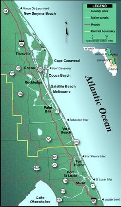
The Indian River Lagoon (IRL) is part of the longest barrier island complex in the United States, stretching across 40 percent of Florida’s east coast. This beautiful lagoon spans 156 miles beginning at Ponce de León Inlet and ending at Jupiter Inlet. The Lagoon varies in width from .5 to 5 miles and has an average of 4 feet in depth. The Indian River Lagoon is a grouping of three estuaries: Mosquito Lagoon, Banana River, and the Indian River, on the Atlantic Coast of Florida.

Lagoons and Estuaries
A lagoon is a body of salt water separated from the deeper sea by a shallow or exposed barrier beach, sandbank, coral reef, or similar feature.
An estuary is a partly enclosed coastal body of water with one or more rivers or streams flowing into it, and with a free connection to the open sea.
Forming of the Indian River Lagoon
In Florida the ocean, due to global changes in sea level over many thousands of years, shaped the estuaries of the Mosquito Lagoon, Banana River, and the Indian River along with the eastern barrier islands. Compared with how long the Indian River Lagoon is, there is a relatively limited exchange of water with the ocean. This limited exchange with the ocean is the reason the estuaries (Mosquito Lagoon, Banana River, and the Indian River) are referred to as lagoons.

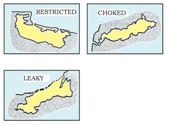
Types of Lagoons
Lagoons are classified into 3 main types; Restricted Lagoons, Choked Lagoons, and Leaky Lagoons:
Restricted Lagoons have multiple channels, well defined exchange with the ocean, and tend to show a net seaward transport of water. Wind patterns in restricted lagoons can also cause surface currents to develop, thus helping to transport large volumes of water downwind.
Choked Lagoons occur along high energy coastlines and have one or more long narrow channels which restrict water exchange with the ocean. Circulation within this type of lagoon is dominated by wind patterns.
Leaky Lagoons have wide tidal channels, fast currents and unimpaired exchange of water with the ocean.
Inlets of the Indian River Lagoon
The Indian River Lagoon exchanges seawater with the ocean through 6 well defined inlets:
1-Ponce de Leon Inlet- a natural inlet.
2-Port Canaveral Inlet- a lock system at Port Canaveral, which limits water the exchange between the Atlantic Ocean and the Banana River.
3-Sebastian Inlet- completely man-made inlet.
4-Fort Pierce Inlet- once had a natural inlet (Indian River Inlet) but it was located north of the current one in the Pepper Beach / Jack Island area. The current Fort Pierce Inlet is an early 20th century man-made replacement.
5-St. Lucie Inlet- (originally Gilbert's Bar) at Stuart is natural, but very erratic and shallows unless it is frequently dredged.
6-Jupiter Inlet- started as a natural inlet that angled to the SE, but was straightened in 1920; the mouth of the inlet used to be about 1/4 mile south of where it is now. Both the natural inlet and the straightened inlet have a history of silting up periodically. Most notably, the original inlet was frequently too shallow for supplies to reach the lighthouse (especially during the original construction) and the new inlet was allowed to close completely during World War II because it was easier to patrol the beach that way.
A special thanks to Joshism for the Inlet history information
Sediment of the Indian River Lagoon
Sediment in the Indian River Lagoon is well mixed due to the influence of wind patterns in the area. Generally, the eastern side of the lagoon along the barrier islands and mainland have sandy, well drained soils. Moderately to poorly drained soils occur in the tidal swamps and on the western side of the lagoon along the barrier islands. Areas of the Indian River Lagoon that are a few miles north or south of ocean inlets also experience tidal influences which increases sediment load. Lastly, seasonal storm events, which are often seen during Florida's rainy season, along with hurricanes greatly increase sediment load and mixture in the Indian River Lagoon.
To get credit for the cache, please answer the questions below. When answering the questions, do your best. It is more important that you learn a new concept about our earth, and can apply your knowledge rather than have a precise answer.
Questions:
1- What type of Lagoon is the Indian River Lagoon? (Restricted, Choked, or Leaky)
2- Describe the color and composition of the soil you see in the water by the coordinates.
3- Classify the wind speed at the time of your visit on a scale from 1 to 5 (1 = little or no wind to 5 = strong winds).
4- Why do you believe the soil is the way it is at this specific location in the Indian River Lagoon?
Thank you for visiting this earthcache. Please send your answers to the above questions to the cache owner. In your "found it" log feel free to write about your experience, but don't include the earthcache answers. Thanks and we hope you enjoy the beautiful Indian River Lagoon!

Sources:
http://www.sms.si.edu/irlspec/Whatsa_lagoon.htm
http://www.sms.si.edu/irlspec/Maps.htm
http://en.wikipedia.org/wiki/Indian_River_Lagoon
http://biopublisher.ca/index.php/ijms/article/html/725/
http://floridaswater.com/itsyourlagoon/
http://en.wikipedia.org/wiki/Indian_River_Lagoon#mediaviewer/File:Indianriverlagoon.GIF
http://education.nationalgeographic.com/education/encyclopedia/lagoon/?ar_a=1
http://www.indianriverkeeper.org/Connecting_people_to_the_sea.pdf
http://www.sfwmd.gov/portal/page/portal/pg_grp_sfwmd_watershed/portlet%20-%20coastal%20ecosystems/tab1806037/irlswim99/appendixb.pdf