Grierson Hill SlideThe hillside before you has quite a brief history in terms of geological time; the North Saskatchewan River valley meandering through Edmonton is only about 12,000 years old.
Where Did The River Come From?
From the year 35,000 BCE to 20,000 BCE, Alberta (with the exception of the southeast corner) was covered in a glacier one kilometre thick, known as the Laurentine Glacier (yegishome.ca, 2005). As the climate changed, this massive and heavy ice sheet gradually melted. For what is estimated to be around 100 years, there was a massive lake held back by an ice dam (yegishome.ca, 2005). The rivulets flowing over this glacier emptied into Glacial Lake Edmonton and deposited a layer of soil 15 meters deep which forms the topsoil of our prairies and boreal forests today (yegishome.ca, 2005).
Eventually this ice dam had to break and when it did everything for hundreds of kilometers around would have known. A monumental amount of water tore forth from the breach and the flow took the most natural downhill path. The power of the flow dug a deep channel through the soft topsoil and evidence is still visible as Coal Lake and Saunders Lake between Leduc and Wetaskwin (Godfrey, 1993). Eventually this water dissipated over the wide area of Alberta. With the weight of the ice and water gone, the ground which had been depressed under the massive weight began to bounce back up (yegishome.ca, 2005).
The ice sheet broke up over time and the melt water began to follow today’s course of the North Saskatchewan River (which flows from the Rocky Mountains).
The Story Behind the Slide
“If it were not for the water in soil we wouldn’t need soil mechanics as a separate engineering discipline.”
-Dobroslav Znidarčić
Nature does not prefer a static perpetual state. Landmasses are constantly being built up, ground down, or gradually relocated elsewhere. The North Saskatchewan River is no exception to this rule, and like every river, it has the ultimate goal to be a straight channel. As a river meanders, the riverbanks are always shifting and changing form. On a bend, the water must flow at constant rate. This results in a faster flow rate at the outside of a bend; since the water must travel a longer distance in the same amount of time as its counterpart in the smaller radius. This results in steep undercutting on the out radius while material is deposited on the inner radius.
Grierson Hill just happens to lie on the outer radius of one of these river bends. Due to a lack of understanding of soil mechanics and/or greed, this hill has proven to be a costly endeavour for the City of Edmonton to fix and has resulted in past property damage (yegishome.ca, 2005).
Figure 1: The location of Grierson Hill (Godfrey, 1993)
When European settlers arrived in Edmonton, the top of this hill seemed like an ideal place to build. After all there is a great unobstructed view from the hill’s crest. Edmund Del Grierson (for which the hill is named) was one of the settlers and, in 1892, he and his business partner Fred Jackson purchased the Queens Hotel on Jasper Avenue. The two men were the backers of the Alberta Hotel, built on Jasper Avenue and 98th Street, overlooking the lip of the valley. The hotel, which opened in 1903, featured the first elevator in Edmonton and even boasted shower baths. Riding the publicity from his new hotel and his reputation, Grierson was elected alderman in 1904 (yegishome.ca, 2005).
Four items contribute to the severity of the slide at this site:
- The slope is steeper than many locations in the city ranging from 45-60 degrees
- The outer radius of the North Saskatchwan cuts away at the slope and undercuts the toe
- The slope is made of bentonite, a fine clay material deposited in Glacial Lake Edmonton which becomes slippery and weak when saturated
- Natural springs infuse the slope with water and saturate the soil
Further items have weakened the slope:
- Coal mining
- Dumping garbage into the cracks formed by slope failure, therefore adding weight (Godfrey, 1993)
- Constructing structures at the crest, which adds weight
- Building storm sewers to discharge storm water onto the slope
(Mussieux & Nelson, 1998)
 Figure 2: The faliure of Grierson Hill was greatly accelerated by human activity (Godfrey, 1993).
In 1880, William Humberstone arrived and started an operation of burrowing into the hillside in search of coal. For 22 years he was in operation mining away under the current 97 Street and extracted 15 million tons from the mine. Two major slides occurred in 1901 (seven buildings damaged) and 1915 (nine buildings damaged) and caused major fracturing at the crest and damaged buildings (Godfrey, 1993). The city engineer was immediately able to come to the conclusion that the mine has weakened the slope substantially (yegishome.ca, 2005).

Figure 3: The damage to properties at the crest of the hill caused by land subsidence when the coal line caved in (Godfrey, 1993).
In 1950, a 1200-foot drainage tunnel, at a cost of $140,000 was installed in the slope in an attempt to draw away collecting water which was keeping the slope in a saturated state and causing slope failure. This drainage pipe helped a little but the slope still continued on its path downhill.
When the Shaw Conference Centre was built in 1980, significant work went into engineering the structure so that it would not move and slope on which the building sits on would be stable (Godfrey, 1993). Deep foundations and retaining walls were built and cables extending far back under Jasper Avenue hold the building back from travelling down the hill (Mussieux & Nelson, 1998).
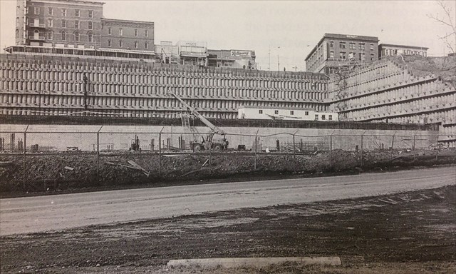 Figure 4: The Edmonton (Shaw) Conference Centre under construction (Godfrey, 1993)
Currently a large wall of boulders (known as rip-rap) lies at the base of Grierson Hill/Louise McKinney Park on the shores of the North Saskatchewan in an attempt to stop the undercutting action of the river (Godfrey, 1993). In addition, the extra load placed at the toe should slow down the slump of the slope downhill (Godfrey, 1993).
The top of Grierson Hill Road from the convention centre upward also features a large retaining wall to hold back the slope.
Questions
Please e-mail me the answers to the following questions through my geocaching.com account. Feel free to log right away without a response from me but I expect answers within a reasonable amount of time. Logs without questions will be deleted.
1.) Estimate the volume of the rip rap (piled-up, rough angular boulders) along the shoreline (length x width x height x 0.5)
2.) Name another location in the city where a major landslide has taken place.
3.) List three things you can do to reduce the risk of landslide and what things have the City of Edmonton done to address potential slides?
4.) What major civil engineering project will be bored into this hillside soon? This will require internet research and is not found on a plaque or sign nearby.
5.) Why do you think this land is a park and has not been used for something else?
References
Godfrey, John. (1993). Edmonton Beneath Our Feet: A Guide to the Geology of the Edmonton Region. Edmonton, AB: Edmonton Geological Society.
Mussieux, R. & Nelson, M. (1998). A Traveller's Guide to Geological Wonders in Alberta. Mishawaka, IN: Better World Books.
yegishome.ca. (2005, November). Grierson Hill Slips Into Edmonton's Past. Retrieved from http://yegishome.ca/news/2005/11/03/grierson-hill-slips-into-edmontons-past
This geocache is owned and maintained by a proud GEAA member.

GEAA provides general information about geocaching, encourages newcomers, and promotes the hobby of geocaching through fellowship, education, and advocacy with land managers and government.
As the geocache owner, I affirm that the image above links to a local geocaching group that is active in the community and contributing to geocaching in a positive way. The link has not been checked by Geocaching HQ or by the reviewer.