[JP]
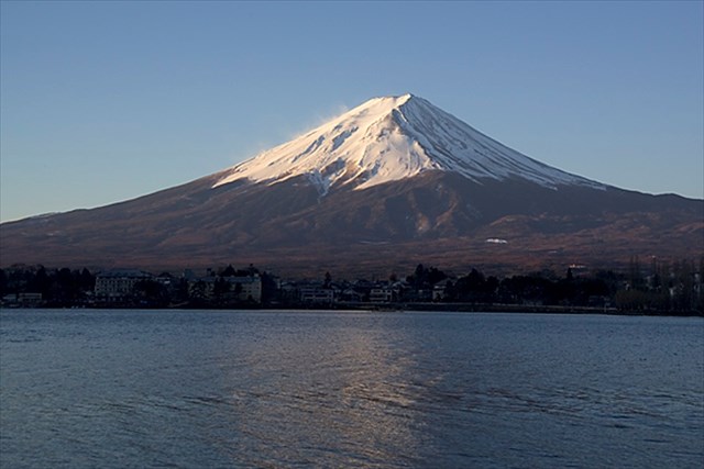
富士山は標高3776mの日本最高峰の活火山です。
[EN]
Mt. Fuji is the highest mountain in Japan with the height of 3776 m and an active volcano.
富士山の噴火史/Eruption history of Mt. Fuji
[JP]
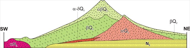
富士山の構造は、下図のように、小御岳火山(αQ2)、古富士火山(βQ2)、新富士火山(αβQ2)に分けられます。
[EN]
The structure of Mt. Fuji is as shown in the figure below with Komitake volcano (αQ2), Old Fuji volcano (βQ2) and New Fuji volcano (αβQ2).
火山活動開始期/Beginning of volcanic activity
[JP]
富士山の周辺一帯は数百万年前から火山活動が活発であったことが知られています。この時期は、伊豆半島がユーラシアプレートに衝突した時期と一致しており(私の他のEarthcacheである丹那断層参照)、この衝突のエネルギーにより火山活動が活性化されたものと考えられています。
[EN]
It is known that volcanic activities around the present Mt. Fuji started about several million years ago, which coincided with the time when Izu peninsula started to collided with Japan island (see my another Earthcache "Tanna fault"). It is assumed that the energy of this collision activated the volcanic activity there.
小御岳火山/Komitake volcano
[JP]
約70万年前、現在の富士山の位置に小御岳(こみたけ)火山が活動を始めました。
[EN]
About 700 thousands year ago, Komitake volcano started its activity at the place of the present Mt. Fuji.
古富士火山/Old Fuji volcano
[JP]
小御岳火山がしばらく休止した後、約10万年前から新たな活動時期に入りました。この時期を古富士火山と呼びます。古富士火山は爆発的な噴火が特徴で、大量のスコリア・火山灰や溶岩を噴出し、標高3000mに達する大きな山体を形成していきました。
約1万1000年前に噴火の形態が大きく変わり、その後約2000年間は断続的に大量の溶岩を流出させました。富士山の溶岩は、珪酸成分が少ない玄武岩質で、粘性が低くて流動性が良く(珪酸成分の増加とともに溶岩の粘性も増加します)、遠くまで流れる傾向があります。この時期に噴火した溶岩は最大40kmも流れており、南側に流下した溶岩は駿河湾に達しています。
[EN]
After Komitake volcano took a pause for a while, a new volcanic activity started 100 thousands year ago, which is called as "Old Fuji volcano". Old Fuji volcano was characterized in that it had explosive eruptions, eructed a lot of volcanic scoria, ash and lava, and formed a huge mountain body with a height of up to 3000m above the sea level.
About 11 thousands years ago, the type of eruption changed dramatically, a lot of lava flew out continually for 2 thousands years. The lava of Mt. Fuji is basaltic, containing less silicate. It has a low viscosity and a high flowability(the more silicate it contains, the more flowable it becomes), tends to flow a long way. The lava during this era flew over 40 kilometers long and reached Suruga bay in the south.
新富士火山/New Fuji volcano
[JP]
古富士火山の溶岩流のあと約4000年間平穏でしたが、約5000年前から新しい活動時期に入り、現在に至るこの火山活動を新富士火山と呼びます。確認されている最後の大噴火は1707年の宝永大噴火であり、この噴火により、側火山側火山である宝永山の噴火口ができました。
[EN]
There was a calm period for about 4000 years after the lava flow of Old Fuji volcano, but new volcanic activities started about 5000 years ago. The volcanic activities since then to the present is called as "New Fuji volcano". The last major eruption confirmed was Houei eruption in 1707, which created the eruptive crater of Mt. Houei as a lateral volcano.
三島溶岩/Mishima lava
[JP]
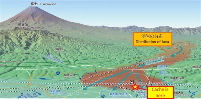
三島溶岩は、約1万年前に流出した溶岩で、現在の三島市まで達しました。有史以来、開発によって大部分の溶岩は除去されたり地下に埋もれたりしていますが、このキャッシュがある楽寿園内では現在でも観察することができます。
[EN]
Mishima lava flew out about 10 thousands years ago, and reached current Mishima city, which lava you can observe even now in Rakuju park in which this earthcache is placed.
低粘性溶岩の特徴/Characteristics of low viscosity lava
[JP]
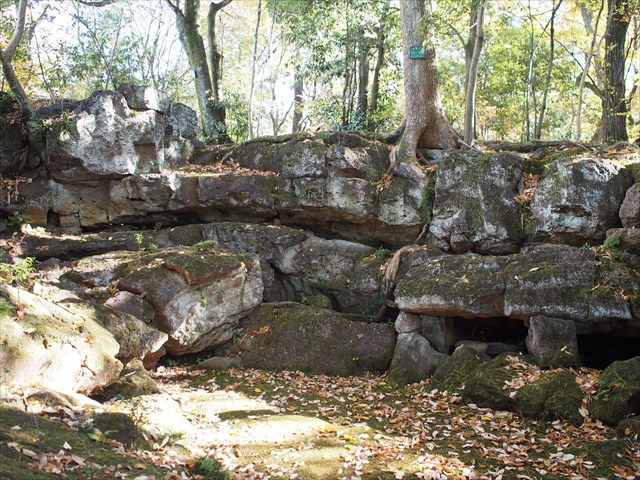
三島溶岩は流動性に富む玄武岩質であり、楽寿園内では、このような流動性に富む溶岩に特徴的な溶岩形態が観察されます。そのような溶岩形態に溶岩塚があります。このような溶岩塚の断面(下写真参照)を、Additional Waypoint”溶岩塚_Lava tumulus”で観察することができます。
[EN]
Mishima lave is basalt with high flowability. you can observe lava forms characteristic to such flowable lava. One of such lava form is "lava tumulus". You can see a cross section of such a lava tumulus at Additional Waypoint ”溶岩塚_Lava tumulus” (see the picture below).
[JP]
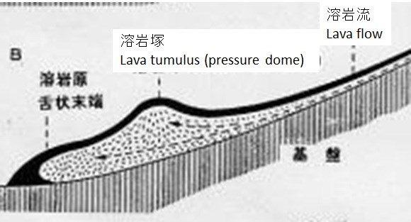
溶岩塚は次のような過程で形成されます(下図も参照)。
1.溶岩流の表面が冷えて固まり始める。
2.内部の溶岩は高温のため流動性を保っており、上流から流れてくる更なる溶岩により押されて内部の圧力が高まる。
3.内部の圧力によって、固まりかけた表面が盛り上がる。その際、表面に割れ目ができる場合もある。
[EN]
A lava tumulus is formed with the following steps (also see the figure below):
1. A surface of lava flow gets cooled and starts to solidify;
2. Lava inside remains its high temperature and thus flowabilty. The pressure inside increases due to pushing force of further lava flowing from upper stream;
3. The solidifying surface rises due to the increasing pressure inside. Cracks sometimes happens on the surface.
パホイホイ溶岩とアア溶岩/Pahoehoe lava and aa lava
[JP]
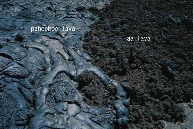
低粘性溶岩が冷えて固まった溶岩は、表面の形態に応じてパホイホイ溶岩とアア溶岩に分類されます。
--パホイホイ溶岩は、表面が平滑で丸みを持ち、波状や縄状の模様が見られます(下写真左)。
--アア溶岩は、表面がスラグ(鉱滓)で覆われたような、ガサガサで刺々しい状態になったものをいいます(下写真右)。
[EN]
Cooled and solidified lavas with a low viscosity are classified into "pahoehoe lava" and "aa lava" depending on their surface appearances.
- Pahoehoe lava has a smooth, billowy, undulating, or ropy surface (left part of the picture below).
- Aa lava has a rough or rubbly surface composed of broken lava blocks called clinker (right part of the picture below).
[JP]
パホイホイ溶岩とアア溶岩の違いは、冷却固化してできる表面冷却殻が連続体として保たれるか、破壊されクリンカーが生じるかと言う点にあります。実際には温度の低下や石基結晶度の増大などによる粘性の増大、または同じ粘性なら変形速度が大きくなることでパホイホイ溶岩からアア溶岩への変化が起きます。温度低下、結晶度増加は流下するにつれて進行するので、流下するにつれてパホイホイ溶岩からアア溶岩へ変化することが一般的ですが、変形速度が律速している場合には、急斜面でアア溶岩だった溶岩流が緩斜面で再びパホイホイ溶岩に変化する例も知られてます。
[EN]
The difference between pahoehoe lava and aa lava is not in their compositions, but in that whether a surface cooled shell is kept as a continuous surface, or breaks and causes clinkers. In practice, an increase of a viscosity due to a drop in temperature or an increase of matrix crystallinity, or if the same viscosity, a deformation rate of lava surface cause a change from pahoehoe lava to aa lava. A drop in temperature and an increase of crystallinity progress as the lava flows down, so it is typical that pahoehoe lava changes into aa lava as it flows down. However, when it is deformation rate-controlled, aa lava at a steep slope may change again into pahoehoe lava at a gentle slope.
Task
[JP]
以下のQ1-Q3の答えをCache ownerに送ってください。
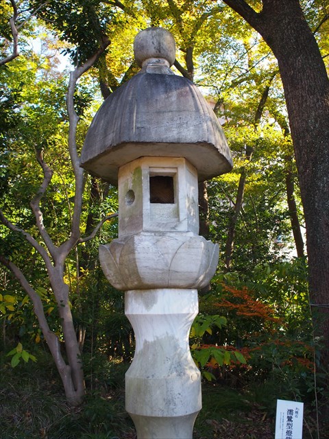
Q1. 座標付近で観察される溶岩の表面はどのような形態でしょうか? 下写真の石灯籠の3mほど左を観察するとよいでしょう。
Q2. あなたがQ1で観察した溶岩は、パホイホイ溶岩でしょうか、アア溶岩でしょうか?
Q3. あなたがQ1で観察した溶岩が座標付近に流れ下った当時の温度・流下速度について、どのようなことが推定されますか?
[EN]
Send to the cache owner your answers to the questions, Q1-Q3 below:
Q1. What is the surface form of lava you can observe at the published coords? When GPS signals are weak, please look at about 3 m left from the stone lantern of the picture below.
Q2. Is the lava you observed in Q1 a pahoehoe lava? or aa lava?
Q3. What can be assumed about the temperature and flowing speed of lava when it came down to the coords?