If I delete your found log due to lack of following instructions, you can re-log your find when you are able to comply.
As this is an earthcache, there is no container to be found; instead, you will take two sets of measurements while paddling in Lake St. Clair, make observations, and then send answers to the questions below to the cache owner. For this earthcache, you will paddle to two locations to take measurements with special equipment. You will also drive to a nearby location to make observations. Please read the general information text for help in answering the questions.
The two paddling locations for measurement are separated by a peninsula in the lake. There are two launch spots across the street from one another. You may either paddle from one launch spot to the other, or do two launches from the two parking areas for two separate paddles. It is recommended that you do this earthcache in conjunction with GC5HD6C - Underwater Vision? as measurements required for that one will be taken at the same two locations.
Equipment needed for this cache:
- approximately 120 feet of line with a minimum of 5 pounds of weight attached.
- a ruler.
You may make your own, borrow them from someone, or borrow my line with weight and my ruler. Because GC5KP62 - "Christmas Trees Gone Bad" - The Repository is currently unavailable, you may pick up my gear at N 47° 00.366 W 122° 42.185 in the large container next to an old post under some trees - not the grey one across the street. My line is long enough, has a weight, and is marked in 10 foot increments to make your measuring easy to do.
Steps to complete this earthcache may be done in any order. There are three steps:
1. Paddle to the general area of the Stated coordinates. Take a depth reading and a GPS reading.
2. Paddle to the general area of the Waypoint 1 coordinates. Take a depth reading and a GPS reading.
Note: try to keep the depth line straight - if your line has an angle, your measurements will be greater than actual depth.
Note: the stated coordinates and the waypoint are where I was when I gathered information for the earthcache. They are meant as guidelines to get you to the general areas; your GPS readings may be a bit different.
3. Drive to the Waypoint 2 coordinates at Eaton Creek. Observe whether this stream, which flows into the lake, is moving toward the lake at the time of your visit. This may be done by dropping a small leaf into the water and watching how quickly it moves. (I have never been able to observe the inflow location into Lake St. Clair, although at low water, I have heard it.)
Questions to answer:
- messages sent through the message center will receive prompt responses. Messages sent in other ways will have to be copied by me into the message center before I can respond. Please log your find as soon as you send answers - don't wait for permission."
Send answers directly to me. Please do not put the answers in your log. If possible, use the message center; my responses will be sent more promptly that way. You will need to read the text as well as taking measurements for the answers. Answers must be sent in a timely manner to avoid deletion of your found log.
1. State the depth and the GPS reading at each of the two sites to which you paddled. It is not critical to be at the exact coordinates given to take the readings. Those are simply guidelines to get you to the general locations.
2. What type of kettle is Lake St. Clair? Why?
3. Look at a map of the general area. Spot the small, unnamed, 5 acre body of water just east of Lake St. Clair. What type of kettle do you think this is? Why?
4. What do you see above the surface of the water in Lake St. Clair that also indicates it is a kettle?
5. Looking at the map, how many ice blocks do you think it took to form Lake St. Clair?
6. Reading the general information, give at least three ways in which Lake St. Clair is unusual from most kettles.
7. Each cacher should post a photo of themselves using the equipment at one of the two sites. If your face shows, great, but that's not necessary.
General information:
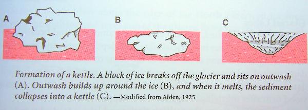
About 15,000 years ago, the Puget Lobe of the Vashon glacier, that was covering this area, began to melt and retreat. During this retreat, chunks of the ice broke off and were covered with glacial/outwash. When the blocks later melted they left behind depressions called kettles.
Unlike other kettles in the Thurston County area, Lake St. Clair is unusual in that it is a series of connected kettles.
Most kettle holes are less than 1.5 miles in diameter with a depth of less than 35 feet. In most cases, kettle holes eventually fill with water, sediment, or vegetation.
If the kettle is fed by surface or underground rivers or streams, it becomes a kettle lake. If the kettle receives its water only from precipitation, the groundwater table, or a combination of the two, it becomes a kettle pond or, if vegetated, a kettle wetland. Kettle ponds that are not affected by the groundwater table will usually become dry during the summer months, in which case they are deemed ephemeral. Kettles that fill with sediment form kettle bogs or peatlands.
Source is general information from many readings and earthcaches done over the last 10 or so years.