The Yorkshire Dales are famous for their rocks and there are numerous earthcaches scattered around looking at the more dramatic features of the landscape - the limestone pavements, the extensive cave systems, and the various other well known features that people travel far and wide to visit. However, there is more to the geology of the area than just limestone, and for me, the summit of Great Whernside is a little taste of home.
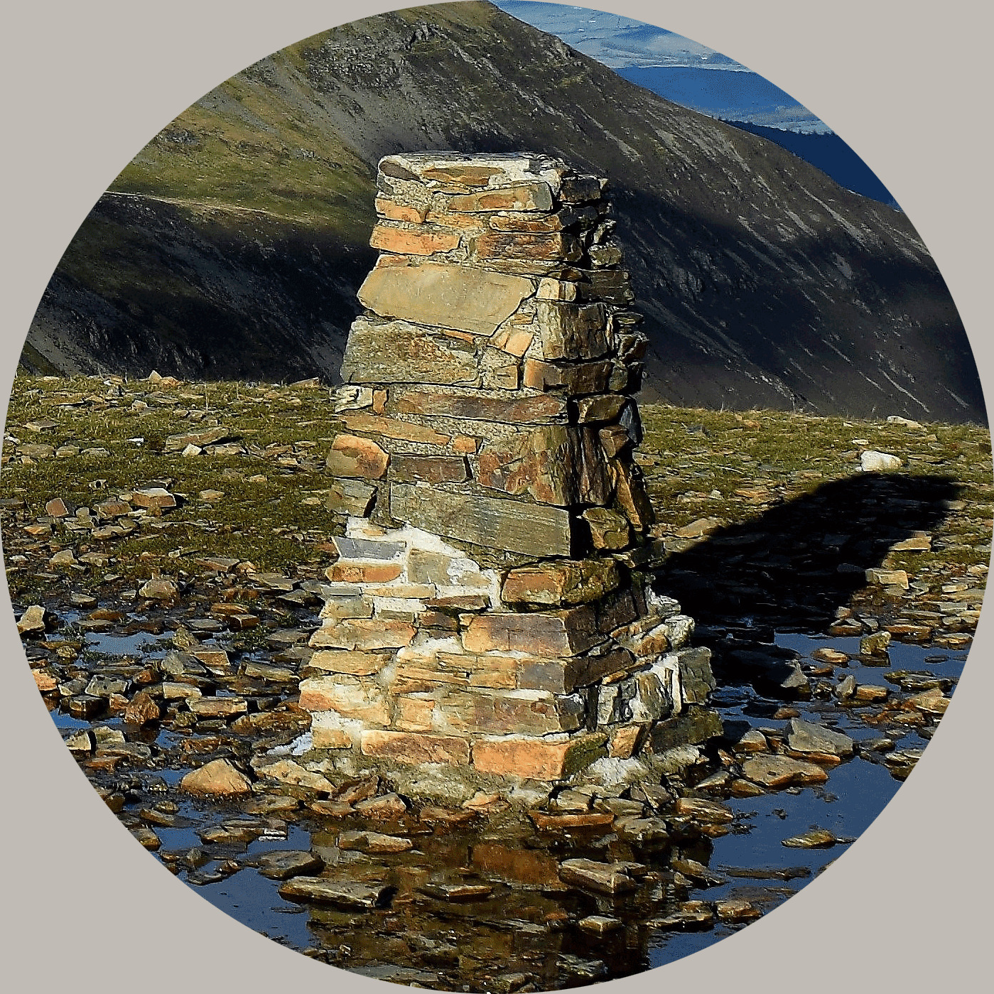
In 2024 this EarthCache joined the YOSM family, as the main destination is looking at the rocks under the trigpoint, and essentially, much lower underneath the trigpoint, which you can see as you walk up. It isn't intended to be difficult, just something you can keep an eye on as you climb the hill and then have a look at the summit rocks which may not be what you'd first assume.
Wharfdale itself is geologically split into two sections. South-east of Burnsall you will find the lands of the Upper Carboniferous era beginning, with heather moorland and hard crags and tors. Places like Ilkley Moor are famous for the Millstone Grit that makes up the area, but up here to the north-west of Burnsall we are very much in the land of the Lower Carboniferous era, where the Great Scar Limestone forms a basement to the overlying Yoredale Beds, a 300-metre sequence of hard limestones, sandstones and soft shales. These strata have been only slightly tilted, down to the east.
There are various ways to approach the summit of Great Whernside, and depending on your choice of route you may pass different features. Ideally, you will have climbed here from Wharfdale from somewhere like Kettlewell or Buckden. If so, you won't help but notice the effect of the weathering of the Yoredales. This has produced the classic stepped profile which can be seen in the valley sides, with a shelf of limestone, sometimes grassy but often displaying karst features such as limestone pavement, gorges and sinkholes. If you climb up through the valley from Kettlewell for example, via Providence Pot, look at the rock underneath the stream, it's very impressive.

The Dow Cave system contains the remarkable Dowbergill Passage, 10-25 metres high but only 1 metre wide and completely straight for 1,500 metres. It was produced by solution along a fault and the stream goes through a spur of Great Whernside, sinking on one side and rising on the other. The Dow Cave system links to Providence Pot.
On the tops of the hills can be found unexpected ponds – Birks Tarn, Fountains Fell Tarn are good examples – where the impermeable layers hold up little peaty pools. The limestones below contain corals and brachiopods and also minerals, of which lead once formed a major local industry - and Kettlewell at the foot of Great Whernside is a good example - profitable lead mining. This industry bought prosperity to the village of Kettlewell in the 17th century but closed in the late 19th century. One of the most profitable was Old Providence which was worked by the Kettlewell Mining Co.
As you climb further up Great Whernside you will leave the limestone layer behind and pass through a layer of shale, which then slopes up to the next limestone shelf. I'll get a little bit more technical for a minute about the rocks and their formations for those of you particularly interested in this geology.
The principal outcrops of Great Scar Limestone and its distinctive landforms, technically known as 'karst', lie in the south-west part of the Dales, between Kingsdale and Wharfedale, an area historically known as Craven. Here it forms a wide, sweeping, now largely treeless landscape with thin calcareous soils and short green-turfed pastures subdivided by white dry-stone walls, and with dramatic outcrops of bare rock, either as steep cliffs known as 'scars' or as seemingly barren, but lichen-covered, limestone pavements. The distinctive profiles of the Three Peaks of Ingleborough, Whernside and Pen-y-Ghent rise above this karst landscape. Streams flowing off the hills disappear through sinkholes into a complex network of underground passages, some to reappear as springs. The limestone has been quarried for centuries. Its purity means that it is very important for the chemical industry but today the main product is aggregate for the construction industry.
Limestone is also a main constituent of the Yoredale Series rocks which overlie the Great Scar Limestone. Deltas emerging from rivers eroding the landmass to the north dropped muds and sands into the seas in which these rocks were formed. Periodic earth movements influenced both sea depth and delta activity, resulting in the rhythmic succession of deposits of limestone, shale and sandstone, the latter sometimes overlain by a thin coal seam, followed by limestone, shale and sandstone....which together form the Yoredale Series.
The surface features are no less dramatic. In the last glaciation, a local ice cap at the head of the Dales fed valley-glaciers and produced the classic U-shaped profiles. There was probably a glacial lake, overlooked by Kilnsey Crag, and opposite is the narrow dry meltwater channel of Conistone Dib, with a deeply-incised gorge called the Gurling Trough. To the south, Dib Scar is a dry former waterfall, similar to the better-known Malham Cove in Airedale. The glacier scoured the limestone, producing the pavements which have since weathered into raised ‘clints’ and the cracks, ‘grykes’, between them.
Questions to answer:
Section A - To be answered in your online log (observations on route to GZ)
Regardless of the route you have taken to reach the GZ of this earthcache you will have started somewhere in a valley and climbed the hill, passing some of the features I have mentioned in the text above. Please give some description of the route you took to reach here intermingled with the below observations you have made. Photographs would be welcomed to illustrate your notes, but are not a requirement. There are no right or wrong answers, it will depend on the route you take and therefore everyone will observe different things which makes this question interesting.
- Look out for limestone features. Note any evidence of steps, caves, scars, clints and grykes, sink holes etc? Any peaty pools as you get higher?
- Include notes about the layers that make up the hill as you climb - did you notice the limestone layers and shale or sandstone layers? How many layers of limestone did you pass as you climbed, and did you notice any differences as you got higher?
- Can you spot any examples of weathering or glacial activity?
- Do you notice changes in the plants as the layers change?
Section B - To be messaged to me via my profile (at GZ - do not include in your log please)
Having arrived at the GZ, you have also reached the summit of Great Whernside. At the trigpoint, under it and all around you will find the sprinkling of the dramatic large rocks that top Great Whernside. Given the geology of the area, you would expect this rock to be limestone. Limestone is a soft rock, relatively smooth and easily weathered usually with relatively small grains making up the rock (you have hopefully observed plenty on your climb up the hill). Please look and touch the large rocks up here.
- What is the texture? Smooth or rough? Grain size?
- What is the erosion status compared with the rocks lower down?
- Do you think these rocks are limestone, and if not, what rock?
- Why is there only a scattering of these rocks up here?
- Please add a photograph of yourself with the trigpoint as proof you visited this YOSM location
Please message me your answers to section B before logging your find. If you do not send in your answers or fail include the answers to section A in your log, it may be necessary for your log to be deleted. However, you do not need to wait for my response and you would receive warning prior to a log deletion.
About Ye Ole Survey Monuments
|
 |
Ye Ole Survey Monument (YOSM) is a captivating series of caches that pays homage to the remarkable legacy of OutForTheHunt's YSM series (GC45CC).
YOSM caches are strategically positioned at or near Trig Points. These triangulation stations have played a pivotal role as surveying landmarks, contributing to the mapping of expansive territories.
Some of these points, bearing historical significance, might now be situated on private land or have vanished with time. As a result, the caches are artfully placed in close proximity, reverently acknowledging the historical importance of these survey monuments.
|
More information, bookmarks and statistics can be found at the YOSM Website
If anybody would like to expand the Ye Ole Survey Monuments Series, please do.
I would ask that you request a number for your cache first at www.yosm.org.uk
so we can keep track of the numbers and names to avoid duplication.